
Hampden Township is the largest municipality by population in Cumberland County, Pennsylvania, United States. The population was 28,044 at the 2010 census, up from 24,135 at the 2000 census.

Springfield is the county seat of Robertson County, Tennessee, United States. It is located in Middle Tennessee near the northern border of the state. As of the 2020 census, the city's population was 18,782.

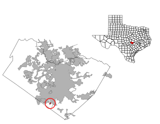
Timberwood Park is a census-designated place (CDP) in far northern unincorporated Bexar County, Texas, United States and located within the southern edge of the Texas Hill Country. The district has roughly 42 miles of roads and encompasses over 2,000 acres. The overall plan shows 3,263 platted lots. The population was 35,217 at the 2020 census, up from 13,447 at the 2010 census. It is part of the San Antonio Metropolitan Statistical Area.

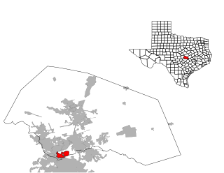
Four Corners is a census-designated place (CDP) within the extraterritorial jurisdiction of Houston in Fort Bend County, Texas, United States. The population was 12,103 at the 2020 census, up from 2,954 at the 2000 census.

Barton Creek is a census-designated place (CDP) in Travis County, Texas, United States. As of the 2020 census, the CDP population was 3,356.
Bee Cave is a city located in Travis County, Texas, United States. Its population was 9,144 as of the 2020 census.
Briarcliff is a village in Travis County, Texas, United States. The population was 2,062 at the 2020 census.

Hudson Bend is a census-designated place (CDP) in Travis County, Texas, United States. The population was 4,005 at the 2020 census.

Lakeway is a city in Travis County, Texas, United States. The population was 19,189 at the 2020 census, an increase over the figure of 11,391 tabulated in 2010. The city is located next to Lake Travis. It is an exurb in Greater Austin.

Lost Creek is an affluent upper-middle-class neighborhood and census-designated place (CDP) in Travis County, Texas, United States. The population was 1,276 at the 2020 census. The census tract is bordered by Capital of Texas Highway to the east, Barton Creek to the south, Barton Creek Boulevard to the west, and Bee Caves Road to the north. The Lost Creek CDP encompasses several small neighborhoods—Parkstone, Woods of Westlake, Camelot, and Knollwood—as well as the largest and most populous Lost Creek neighborhood.

Manor is a city in Travis County, Texas, United States. Manor is located 12 miles northeast of Austin and is part of the Austin-Round Rock metropolitan area. The population was 13,652 at the 2020 census. Manor is one of the faster-growing suburbs of Austin. The city was the seventh fastest growing suburb in America in 2018 by Realtor.com and the 17th best small suburb to live in by U.S. News and World Report in 2019.
San Leanna is a village in Travis County, Texas, United States. The population was 522 at the 2020 census.

Shady Hollow is a census-designated place (CDP) in southwestern Travis County, Texas, United States, and is partially in the City of Austin. It is located ten miles (16 km) southwest of Downtown Austin, near the Travis/Hays county line. The population was 4,822 at the 2020 census.
Wells Branch is a census-designated place (CDP) in Travis County, Texas, United States. The population was 14,000 at the 2020 census.

West Lake Hills is a city in Travis County, Texas, United States. The population was 3,444 at the 2020 census. The city developed rapidly in the 1970s and 1980s on the south side of the Colorado River.
Anderson Mill is a neighborhood of Austin and a former census-designated place (CDP) in Travis and Williamson counties in the U.S. state of Texas. The population was 7,199 at the 2010 census.
Jollyville is a neighborhood in the northern part of Austin, Texas, United States. In 2010 it was a census-designated place (CDP) in Travis and Williamson counties, but has since been annexed by Austin. The population of the CDP was 16,151 at the 2010 census.

Leander is a city in Williamson County and Travis County, Texas, United States. The population was 59,202 at the 2020 census and 74,375 at the 2022 census estimate. A suburb just north of Austin, and part of the Greater Austin metropolitan area, it was the fastest-growing city in the United States between 2018 and 2019.
The Wooten neighborhood of Austin, Texas is located in north central Austin. It is bounded by Burnet Road, Anderson Lane, and Research Blvd (183) and bisected by Ohlen Road.
Galindo is a neighborhood in Austin, Texas. The area covers part of ZIP code 78704 in south Austin.
