South Congress

Last updated
South Congress
SoCo
SoCo.jpg
South Congress Avenue leads directly into downtown Austin.
South Congress
Neighborhood Boundaries
Country United States
State Texas
City Austin
Time zone UTC-6 (CST)
  Summer (DST) UTC-5 (CDT)
ZIP Codes
78704
Area code(s) 512, 737

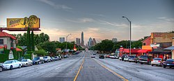
South Congress (abbreviated SoCo) is a neighborhood located on South Congress Avenue in Austin, Texas, United States. It is also a nationally known shopping and cultural district known for its many eclectic small retailers, restaurants, music and art venues and, more recently, food trucks. [1]

Contents

South Congress begins at the Colorado River and Ann W. Richards Congress Avenue Bridge and runs due south towards Ben White Boulevard/TX-71. The area is bordered by two historic South Austin neighborhoods: Travis Heights to the east and Bouldin Creek to the west. [2]

Since its humble beginnings in the 1850s, South Congress Avenue has been transformed from a rural country road to the capital city gateway and, finally, to the shopping district that it is today. Some Austinites attribute its enduring popularity to the unobstructed view of the Texas State Capitol. [3]

History

Edwin Waller designed Congress to be Austin's most prominent thoroughfare in the 1830s. However, Congress did not extend south of the Colorado River until 1852 when James Gibson Swisher donated land for a road that was both the postal route to Austin and the main highway to San Antonio. Growth along South Congress slowed during the 19th century; it was not until the completion of a concrete bridge in 1910 that South Austin had reliable transportation over the river. Rapid growth finally came to South Austin in the 1920s, as the streetcar was expanded down South Congress. As hundreds of bungalows were built in South Austin, more commercial enterprises began appearing south of the river - especially on South Congress. [4] By 1931, South Congress was finally paved all the way from the river to the railroad at present-day Ben White Boulevard.

Many of South Congress's icons opened their doors between 1930 and 1960. The Austin Motel opened in 1938 and the Hotel San José shortly thereafter. The hamburger stand that would eventually become the legendary Night Hawk opened on South Congress in 1932. Another major development was the Twin Oaks Shopping Center at the northeast corner of Oltorf Road and South Congress. It was one of Austin's first "strip" shopping venues when it opened in 1954. South Austin opened further during the 1950s, as the Congress Avenue Bridge was widened and the construction of Interstate 35 provided an alternative north–south route. [5]

During the 1970s, South Congress became a mecca for artists, musicians and their supporters. The legendary Armadillo World Headquarters opened at the corner of South Congress and Barton Springs Boulevard in 1970. Tourist traffic declined on South Congress with the rise of I-35 and many businesses fell into disrepair. [6]

By the late 1980s, small eclectic retailers began popping up along the South Congress Corridor, attracted by cheap rent. The area's renaissance began at the intersection of South Congress and Monroe by putting their historic buildings to good use to attract eclectic retail business, arts and music venues and restaurants in the area. South Austin's first skyscrapers appeared at South Congress and Riverside Drive when two new hotels opened. 1988 was a watershed moment for the area, as Kent Cole and Diana Prechter fixed a beat-up wood-frame building that had operated as Flossie's bar and the Austex Lounge, and reopened it as Magnolia Cafe South. They said they were attracted by the "colorful people" and cheap rent. [7]

Memories of drug dealers and prostitutes began to fade in the 1990s. Austin, a relatively small city for most of its history, suddenly enjoyed a tremendous economic boom that attracted new residents and drove an increased demand for older housing stock in the Travis Heights and Bouldin Creek neighborhoods. That in turn spurred massive renovation along South Congress and throughout old South Austin. The 1990s witnessed the redevelopment of the Austin Theatre, the H-E-B at Oltorf and South Congress and more. Perhaps the most ambitious renovation undertaken was the redevelopment of Penn Field from an industrial plant to a multi-use complex that includes office space, retail and residences. By the end of the decade, South Congress was well on its way to becoming a nationally known shopping and cultural district. [8]

Economy

The shopping district contains numerous shops, restaurants and music venues. [6] There is a square featuring a number of food trucks serving tacos, falafel, cupcakes, and more. Notable retailers on South Congress include Allens Boots (1977), Lucy in Disguise with Diamonds (1984), Uncommon Objects (1992-2017) and Friends of Sound (1996-2016). Restaurants in the area include Guero's Taco Bar (1995), where Texas Radio Live is broadcast on Sun Radio every Wednesday evening, Home Slice Pizza (2005), South Congress Cafe (2003) and Hey Cupcake (2007). First Thursday is a community event held each month where businesses stay open to 10 p.m. or later to celebrate the neighborhood's boutiques, restaurants and galleries. The event is held on the first Thursday of every month between Barton Springs Road and Elizabeth Street. [9]

Sweet Leaf Tea Company has its headquarters in the Penn Field Business Park in the South Congress neighborhood. [10] The company moved to the South Congress neighborhood in 2007. [11] The company moved to Penn Field in December 2009. [10]

Education

The neighborhood is zoned to the Austin Independent School District. The zoned schools are Travis Heights Elementary School, Lively Middle School, and Travis High School. [12] Lively was built in 1911, [13] Travis Heights was built in 1938, [14] and Travis was built in 1953. [15]

Austin Community College serves area residents. St. Edward's University is located on South Congress Avenue. [16]

Public transportation

CapMetro CapMetro Rapid Route 801 traverses South Congress Avenue providing express service to the rest of the city. Specifically, the route has stops at Auditorium Shores, SoCo, Oltorf, and St. Edward's stations. South Congress Transit Center at Ben White Boulevard also provides connection to other bus routes in the area. South Congress will be future served by the Orange Line light rail service as a part of Project Connect. [17]

See also

Related Research Articles

<span class="mw-page-title-main">West Adams, Los Angeles</span> Neighborhood of Los Angeles in California, United States

West Adams is a historic neighborhood in the South Los Angeles region of Los Angeles, California. The area is known for its large number of historic buildings, structures and notable houses and mansions. It contains several Historic Preservation Overlay Zones as well as designated historic districts.

<span class="mw-page-title-main">College Area, San Diego</span> Community of San Diego in California

The College Area is a residential community in the Mid-City region of San Diego, California, United States. The College Area is dominated by San Diego State University, after which the area is named. Several neighborhoods in the College Area were developed in the 1930s, with others becoming established in the post-war period. The College Area is bordered on the west by Kensington and Talmadge and on the east by the city of La Mesa. El Cajon Boulevard is a busy shopping district; additional retail, entertainment and dining establishments are located in a new housing and commercial complex known as South Campus Plaza on College Avenue at Aztec Center. The College Area includes the neighborhoods of the Catoctin Area, Dennstedt Point, East Falls View Drive, Saranac-Mohawk, and an Orthodox Jewish neighborhood in the area near Congregation Beth Jacob Orthodox Synagogue on College Avenue. The region includes Alvarado Hospital, a 306-bed acute care facility, and the College-Rolando branch of the San Diego Public Library.

<span class="mw-page-title-main">Travis Heights, Austin, Texas</span> United States historic place

Travis Heights is a historic neighborhood in south Austin, Texas, United States, bounded by Lady Bird Lake on the north, Interstate 35 on the east, Congress Avenue on the west and Oltorf Street on the south. These boundaries include Fairview Park, an earlier suburb associated with the same developers, running from the west side of Blunn Creek to South Congress Avenue. Part of Travis Heights was stranded east of Interstate 35; many of the same streets to be found west of the highway continue east of it.

<span class="mw-page-title-main">Congress Avenue Historic District</span> Historic district in Texas, United States

Congress Avenue is a major thoroughfare in Austin, Texas. The street is a six-lane, tree lined avenue that cuts through the middle of the city from far south Austin and goes over Lady Bird Lake leading to the Texas State Capitol in the heart of Downtown.

The City of Oklahoma City uses Special Zoning Districts as a tool to maintain the character of many neighborhood communities.

Columbus, the state capital and Ohio's largest city, has numerous neighborhoods within its city limits. Neighborhood names and boundaries are not officially defined. They may vary or change from time to time due to demographic and economic variables.

<span class="mw-page-title-main">Vine Street, Cincinnati</span>

Vine Street functions as Cincinnati's central thoroughfare. It bisects the downtown neighborhood, as well as the adjacent Over-the-Rhine neighborhood. The street also serves as the dividing line for the "east" and "west" sides of the city. All east-west addresses in the city start at zero at Vine Street.

<span class="mw-page-title-main">Downtown Austin</span> Neighborhood in Austin, Texas

Downtown Austin is the central business district of Austin, Texas, United States. The area of the district is bound by Lamar Boulevard to the west, Martin Luther King Jr. Boulevard to the north, Interstate 35 to the east, and Lady Bird Lake to the south.

<span class="mw-page-title-main">Bouldin Creek, Austin, Texas</span> Neighborhood in Austin, Texas, United States of America

Bouldin Creek is a neighborhood in Austin, Texas, originally created at the turn of the 20th century and saw the bulk of its growth in the 1920s and 1930s.

East Riverside-Oltorf is a neighborhood in Austin, Texas, located southeast of the city's urban core. The East Riverside, Parker Lane, and Pleasant Valley neighborhoods together form the East Riverside-Oltorf Combined Neighborhood Planning Area. The region is bounded on the north by Lake Lady Bird, to the east by Grove Boulevard and the Montopolis neighborhood, Texas State Highway 71 to the south, and Interstate 35 and South River City to the west.

Dawson is a neighborhood in South Austin, Texas bordered by Oltorf Road on the north, Ben White/290 on the south, South 1st Street on the west, and Congress Avenue on the east.

<span class="mw-page-title-main">South Lamar, Austin, Texas</span> Neighborhood in Austin, Texas, United States

South Lamar, Austin, Texas is a neighborhood in south Austin, Texas, United States.

Galindo is a neighborhood in Austin, Texas. The area covers part of ZIP code 78704 in south Austin.

South River City is a community located in Austin, Texas. Also frequently called Travis Heights, the neighborhood is located south of the city's urban core, just below Lake Lady Bird in South Austin. The area encompasses a portion of ZIP code 78704.

<span class="mw-page-title-main">Nob Hill, Albuquerque, New Mexico</span> Neighborhood of Albuquerque in Bernalillo, New Mexico, United States

Nob Hill is a neighborhood in Albuquerque, New Mexico, United States, consisting of a commercial district along Central Avenue and surrounding residential areas. Located just east of the University of New Mexico, the neighborhood was developed between about 1925 and 1950 and has since become a popular tourist and shopping destination. Known for its eclectic mix of mostly locally owned businesses, Nob Hill has been described as "the heart of Albuquerque's Route 66 culture and also its hippest, funkiest retail and entertainment district". The neighborhood is named after Nob Hill in San Francisco, California.

<span class="mw-page-title-main">Fifth by Northwest</span> Neighborhood in Columbus, Ohio

Fifth by Northwest is a neighborhood in Columbus, Ohio. Covering about 700 acres (280 ha), Fifth by Northwest is approximately bound by Glenn Avenue, Wyandotte Road, & Kinnear to the north, Third Avenue to the south, Kenny Road and Olentangy River Road to the east and Northstar Road to the west. Also sometimes referred to as 5XNW or the Tri-Village area, Fifth by Northwest is just north of Grandview Heights, northwest of the Harrison West neighborhood, and west of The Ohio State University.

<span class="mw-page-title-main">East Central, Spokane</span> Spokane Neighborhood in Washington, United States

East Central is a neighborhood in Spokane, Washington. As the name suggests, it is on the east side of Spokane and centrally located. The official neighborhood is expansive and covers multiple areas considered by locals to be independent neighborhoods, such as the Sprague Union District on East Sprague Avenue, the South Perry District, the Underhill Park area and the University District on the eastern fringe of Downtown Spokane.

References

  1. "South Congress Avenue Shopping". Austin City Guide. Retrieved October 31, 2011.
  2. "South Congress Avenue & SoCo Neighborhood". Small Planet Guide. 2009. Retrieved October 31, 2011.
  3. Patoski, Joe Nick (July–August 2010). "It's Just Different Here". Preservation. Retrieved October 31, 2011.
  4. "South Congress Avenue Preservation Plan" (PDF). City of Austin. p. 5. Retrieved 2008-07-22.
  5. McGraw, Marburger & Associates. "History of South Congress" . Retrieved October 31, 2011.
  6. 1 2 "South Congress Avenue Preservation Plan" (PDF). City of Austin. p. 17. Retrieved 2008-07-22.
  7. "South Congress Avenue Preservation Plan" (PDF). City of Austin. p. 18. Retrieved 2008-07-22.
  8. Erlichman, Janelle (2002-12-22). "Austin's Vintage Power". Washington Post. Retrieved 2008-07-22.
  9. Longoria, Bobby (February 25, 2011). "South Congress Businesses Flourishing". Community Impact. Retrieved October 31, 2011.
  10. 1 2 "Sweet Leaf triples space, adds flavors and new can." Austin Business Journal . Tuesday January 5, 2010. Retrieved on January 10, 2010.
  11. "Sweet Leaf Tea.(relocates headquarters)(Brief article)." Beverage Industry . April 1, 2007. Retrieved on January 10, 2010.
  12. "School Assignment by Residential Address." Austin Independent School District . Retrieved on April 20, 2009.
  13. "Campus Facts." Fulmore Middle School . Retrieved on April 20, 2009.
  14. "Campus Facts." Travis Heights Elementary School. Retrieved on April 20, 2009.
  15. "Campus Facts." Travis High School . Retrieved on April 20, 2009.
  16. St. Edward's University main campus - Maps & Directions
  17. Clark-Madison, Mike (25 September 2020). "From Light Rail to a Downtown Tunnel: The Parts of Project Connect". Austin Chronicle. Retrieved 5 November 2020.

30°15′N97°45′W / 30.250°N 97.750°W / 30.250; -97.750