
Enfield is a town in Hartford County, Connecticut, United States, first settled by John and Robert Pease of Salem, Massachusetts Bay Colony. The town is part of the Capitol Planning Region. The population was 42,141 at the 2020 census. It is bordered by Longmeadow, Massachusetts, and East Longmeadow, Massachusetts, to the north, Somers to the east, East Windsor and Ellington to the south, and the Connecticut River to the west.
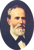
Elisha Marshall Pease was a Texas politician. He served as the fifth and 13th governor of Texas.

Pease Park is an urban park in central Austin, Texas. Paralleling Shoal Creek west of downtown, the park is frequented by University of Texas at Austin and Long-View Micro School students and, formerly, by disc golf enthusiasts. Every spring it plays host to the annual Eeyore's Birthday Party celebration, a favorite event for Austin's hippie subculture dating back to the 1960s.

Woodlawn, also known as the Pease Mansion as well as Governor Shivers’ Mansion, is a pre-Civil War mansion located at 30.2871° -97.7581° in Austin, Texas. The Greek Revival style house was owned by two Texas governors. Some notable people that have visited the mansion include Sam Houston, General George Custer, Elisabet Ney, Will Rogers, and Edith Head. Woodlawn was added to the National Register of Historic Places on August 25, 1970. Although the house faces Pease Rd, it has two separate entrances. One entrance is off Niles Rd and the other is off of Northumberland Rd, which is where the mailbox is located.
The Old West Austin Historic District is a residential community in Austin, Texas, United States. It is composed of three neighborhoods located on a plateau just west of downtown Austin: Old Enfield, Pemberton Heights, and Bryker Woods. Developed between 1886 and 1953, the three historic neighborhoods stretch from Mopac Expressway east to Lamar Boulevard, and from 13th Street north to 35th Street. It borders Clarksville Historic District and the West Line Historic District to the south.

The Clarksville Historic District in Austin, Texas, is an area located west of downtown Austin near Lady Bird Lake and just northeast of the intersection of the Missouri Pacific Railroad and West Tenth Street. Many historic homes and structures are located within the Clarksville Historic District. While Clarksville is geographically part of the Old West Austin Historic District, it is distinct from the two historic neighborhoods of Old Enfield, which lies immediately to the north on the eastern side of Texas State Highway Loop 1, and Tarrytown, which is situated to the west and northwest on the western side of Mopac.
The Ethel Felder Webster House is a historic two-story home in the Enfield historic district in Austin, Texas. The home was built in 1917 and was among the first five built on Enfield Road. All were completed by 1918 and are listed in the city directory for that year. It is the only surviving house of these originals.
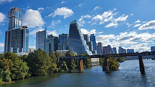
Downtown Austin is the central business district of Austin, Texas, United States. The area of the district is bound by Lamar Boulevard to the west, Martin Luther King Jr. Boulevard to the north, Interstate 35 to the east, and Lady Bird Lake to the south.

South Congress is a neighborhood located on South Congress Avenue in Austin, Texas, United States. It is also a nationally known shopping and cultural district known for its many eclectic small retailers, restaurants, music and art venues and, more recently, food trucks.
East Riverside-Oltorf is a neighborhood in Austin, Texas, located southeast of the city's urban core. The East Riverside, Parker Lane, and Pleasant Valley neighborhoods together form the East Riverside-Oltorf Combined Neighborhood Planning Area. The region is bounded on the north by Lake Lady Bird, to the east by Grove Boulevard and the Montopolis neighborhood, Texas State Highway 71 to the south, and Interstate 35 and South River City to the west.
North Shoal Creek is a neighborhood in north central Austin, Texas established in the 1960s.
Allandale, Austin, Texas is a neighborhood in North Central Austin, in the U.S. State of Texas known for its large lots, mature trees, and central location.
Bryker Woods is an older Austin, Texas, central city neighborhood developed in the 1930s, the center of which is approximately located at 30°18′17″N97°45′06″W. It is predominantly a mix of young and old families and zoned as a single-family neighborhood composed of mostly small homes in good condition, most of which are over 50 years old. The Bryker Woods neighborhood is also part of the Old West Austin Historic District. Bryker Woods has its own elementary school, Bryker Woods Elementary, and is convenient to retail and recreational facilities.
Crestview, Austin, Texas is a neighborhood in north central Austin, in the U.S. state of Texas.

South Lamar, Austin, Texas is a neighborhood in south Austin, Texas, United States.
Westgate is a neighborhood in Austin, Texas, located southwest of the city's urban core. It includes ZIP code 78745.
Galindo is a neighborhood in Austin, Texas. The area covers part of ZIP code 78704 in south Austin.

Pemberton Heights is a neighborhood of Austin, Texas, and part of the Old West Austin Historic District. The area is bounded by Northwood Road on the north, Lamar Boulevard/Shoal Creek on the east, 24th Street/Windsor Road on the south, and Texas State Highway Loop 1 ("MoPac") on the west. It is Austin's wealthiest and most historic neighborhood.
Brown Herman is a northwest central neighborhood located just west of downtown Austin, Texas. It is often included within the boundaries of Tarrytown or Bryker Woods.


