Preservation of View of State Capitol | |
---|---|
![]() | |
Texas Legislature | |
Citation | "Preservation of View of State Capitol" (Texas Government Code § 3151.000) |
Enacted by | Texas Senate |
Enacted | March 24, 1983 |
Enacted by | Texas House of Representatives |
Enacted | April 21, 1983 |
Signed by | Governor Mark White |
Signed | May 3, 1983 |
Effective | May 3, 1983 |
Legislative history | |
First chamber: Texas Senate | |
Bill title | Relating to preservation of the view of the State Capitol from certain points and prohibition of certain construction. |
Bill citation | Tex. S.B. 176, 68th Leg., R.S. (1983). |
Introduced by | Lloyd Doggett |
Introduced | January 17, 1983 |
First reading | January 17, 1983 |
Second reading | March 24, 1983 |
Third reading | March 24, 1983 |
Second chamber: Texas House of Representatives | |
Bill title | Tex. S.B. 176, 68th Leg., R.S. (1983). |
Received from the Texas Senate | March 28, 1983 |
Member in Charge | Gerald Hill |
First reading | April 5, 1983 |
Second reading | April 21, 1983 |
Third reading | April 21, 1983 |
Amended by | |
Tex. H.B. 2812, 77th Leg., R.S. (2001). Tex. H.B. 2256, 83rd Leg., R.S. (2013). | |
Status: In force |
The Capitol View Corridors are a series of legal restrictions on construction in Austin, Texas, aimed at preserving protected views of the Texas State Capitol from various points around the city. First established by the Texas Legislature in 1983 and recodified in 2001, the corridors are meant to protect the capitol dome from obstruction by high-rise buildings. While supported by cultural and historical preservation organizations, the corridors have also been criticized for limiting the potential for the development of new tall structures in downtown Austin.
In 1931, the City of Austin, aiming to preserve the visual preeminence of the 303-foot (92 m) Texas State Capitol, enacted a local ordinance limiting the height of new buildings to a maximum of 200 feet (61 m). From that time until the early 1960s, only the University of Texas Main Building Tower was built higher than the limit, using an exception allowing for additional height with a greater setback. On November 10, 1962, the Austin Statesman announced that real-estate developers were planning a new high-rise residential building adjacent to the Capitol called the Westgate Tower. [1] The proposed design for the tower was 261 feet (80 m) tall, significantly exceeding the city's height limit, although it compensated with a setback for the upper portion. [2]
The prospect of so tall a structure so close to the Capitol met with significant hostility as plans proceeded. In January 1963, Texas Governor Price Daniel voiced his opposition to the proposed tower in his final address to the Texas Legislature. [1] Resistance continued as construction progressed, with State Representative Henry Grover of Houston introducing a bill to condemn the property in February 1965, [3] which was defeated in March in the Texas House of Representatives by only two votes. [4] The Westgate was completed in 1966, but the controversy over the preservation of the Capitol's visual presence that dogged its construction continued to grow. [1]
The Westgate was followed by even taller structures: first the 307-foot (94 m) Dobie Center (designed in 1968), and then a series of ever larger downtown bank towers, culminating in the 395-foot (120 m) One American Center (designed in 1982). [1] In January 1983, inspired by the Westgate and these other structures, State Senator Lloyd Doggett and State Representative Gerald Hill introduced Senate Bill 176, "Relating to preservation of the view of the State Capitol from certain points and prohibition of certain construction." This bill proposed a list of protected "Capitol View Corridors" along which construction would not be permitted, so as to create protected views from a series of points around Austin. [5]
The bill passed through the Texas Senate and House of Representatives in early 1983, ultimately being signed into law on May 3, 1983, and coming into effect immediately. [6] It was later recodified in 2001 by House Bill 2812, which established the current version of the statute in the Texas Government Code Chapter 3151, entitled "Preservation of View of State Capitol". This code defines the thirty state-protected viewing corridors and prohibits any construction that would intersect one of them. [7] In 1985 the City of Austin adopted a corresponding Capitol View Protection Ordinance, [8] so that the majority of the corridors are protected under the Austin Code of Ordinances Chapter 25-2 Appendix A, entitled "Boundaries of the Capitol View Corridors", as well as under state law. [9]
The state legislation defining the corridors was amended in 2001 and 2003 to accommodate a series of public development projects, including the redevelopment of the defunct Mueller Airport and an expansion of Darrell K Royal–Texas Memorial Stadium, [10] and again in 2013 to clarify the relationship between the state and city codes. [11]
In 2007, the Austin City Council asked the Downtown Commission to review the existing corridors and propose updates or modifications. The commission's final report, delivered on June 27, 2007, recommended that eleven of the thirty corridors be reconsidered or modified. [10] Six of the recommended changes were to correct technical errors in the statute or to bring the city and state laws into agreement, and two were to update the laws to reflect portions of the corridors that were already obstructed. [12] The other four recommendations were more controversial, attracting opposition from the city's Parks and Recreation Board, [13] the Heritage Society of Austin, [14] and others; no changes were ultimately made. [15]
In February 2017, the Austin City Council considered a proposal from Council Member Ora Houston to designate additional protected viewing corridors in east Austin. [16] The proposal was provisionally approved by council on February 16, after an amendment removed one of the five proposed new corridors; [17] that corridor was later restored to the proposal on March 2. [18] As of 2021 [update] , city staff are reviewing the proposed additional corridors for feasibility. [19]
Since their creation, the Capital View Corridors have been a frequent focus of conflict among various groups in Austin and in the Texas government. On one hand, cultural conservation and historical preservation organizations have generally supported the restrictions, arguing that the capitol views form an important part of Austin's cultural heritage and are threatened by the city's growth and land development. [20] [21] On the other hand, both private and public entities looking to build in Austin (especially downtown) have expressed concern about the corridors' impact on investment, on property tax receipts, and on the supply of jobs and housing. [16] [22]
A number of high-rise buildings in central Austin have been designed with diagonal floor plans to avoid obstructing a viewing corridor, such as the Fifth & West Residences Tower; other towers suddenly become narrower when they reach the height of a viewing plane, like the 360 Condominiums Tower. [19] Some major civic development projects have received exemptions from the corridor protections, including the redevelopment of the former Mueller Airport and the expansion of the University of Texas football stadium; [10] in other cases, structures already completed have been condemned and rebuilt because of the corridors, including a newly built water intake facility for the Waller Creek Tunnel. [23] Low-lying corridors prevent essentially all construction on certain blocks downtown. [10] [24]
A Capitol View Corridor is a quadrilateral that links a line segment somewhere in Greater Austin to the base of the capitol dome. No structure is permitted to be built in a manner that would intersect the viewing corridor and thus obstruct the protected view of the Capitol. As of 2021 [update] , state law defines thirty Capitol View Corridors in Austin, while municipal code defines twenty-six protected corridors, twenty-one of which are identical to state-defined corridors and five of which differ slightly from five of the state corridors. Many of the corridors protect stationary or pedestrian views, and others protect vehicular views from roadways (some corridors protect both). The corridors have an average length of around 1.5 miles (2.4 km); the shortest runs for 1,700 feet (520 m) to Waterloo Park, and the longest runs 5.7 miles (9.2 km) to a scenic overlook in West Lake Hills. [10]
As of 2021 [update] , state law defines thirty Capitol View Corridors in Austin, while municipal code defines twenty-six protected corridors, twenty-one of which are identical to state-defined corridors and five of which differ slightly from five of the state corridors. [10]
Number | Name | Viewpoint | Type of view | Length | Image |
---|---|---|---|---|---|
1 | South Mall of The University of Texas | South Mall of the University of Texas campus | Stationary | 3,800 feet (1,200 m) | ![]() |
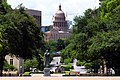
2 | Waterloo Park | Sidewalk along the east edge of Waterloo Park | Stationary | 1,700 feet (520 m) | ![]() |
3 | Wooldridge Park | South edge of Wooldridge Park | Stationary | 1,900 feet (580 m) | ![]() |
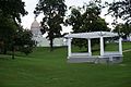
4 | French Legation | Front porch of the French Legation | Stationary, Dramatic Glimpse | 3,800 feet (1,200 m) | |
5 | Lamar Bridge | Lamar Boulevard Bridge over Lady Bird Lake | Threshold | 1.2 miles (1.9 km) | ![]() |
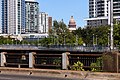
6 | South Congress at East Live Oak | Along Congress Avenue to the capitol terminating vista | Sustained Approach | 2.4 miles (3.9 km) | ![]() |
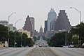
7 | MoPac Bridge | MoPac Expressway bridge over Lady Bird Lake [a] | Threshold | 1.9 miles (3.1 km) | |
8 | South Lamar at La Casa Drive | Northbound lanes of south Lamar Boulevard | Threshold | 3.0 miles (4.8 km) | ![]() |
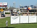
9 | Barton Creek Pedestrian Bridge | Barton Creek Bridge on the Ann and Roy Butler Hike-and-Bike Trail in Zilker Park [b] | Dramatic Glimpse | 1.6 miles (2.6 km) | |
10 | Pleasant Valley Road at Lakeshore Drive | East end of Longhorn Shores park on the south shore of Lady Bird Lake | Stationary | 2.6 miles (4.2 km) | |
11 | East 11th Street Threshold | East 11th Street's elevated crossing over Interstate 35 | Threshold | 3,300 feet (1,000 m) | ![]() |
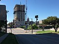
12 | Northbound Lanes of Interstate Highway 35 Between the Municipal Police and Courts Building and West 10th Street | A segment of the northbound lanes of I-35 southeast of the capitol [c] | Dramatic Glimpse | 3,100 feet (940 m) | |
13 | Southbound Lanes of the Upper Deck of Interstate Highway 35 Between Concordia College and the Martin Luther King, Jr. Boulevard Overpass | A segment of the elevated southbound lanes of I-35 northeast of the capitol | Sustained Approach | 1.0 mile (1.6 km) | |
14 | Northbound Lanes of Interstate Highway 35 Between Waller Creek Plaza and the Municipal Police and Courts Building | A segment of the northbound lanes of Interstate 35 southeast of the capitol | Dramatic Glimpse | 3,900 feet (1,200 m) | |
15 | Northbound Lanes of Interstate Highway 35 Between 3rd Street and Waller Creek Plaza | A segment of the northbound lanes of Interstate 35 southeast of the capitol | Sustained Approach | 4,800 feet (1,500 m) | |
16 | East 7th Street Bridge over the Texas and New Orleans Railroad | East 7th Street's elevated bridge over the Texas and New Orleans Railroad tracks | Sustained Approach | 2.4 miles (3.9 km) | ![]() |
17 | Longhorn Shores | South edge of Longhorn Shores park on the south shore of Lady Bird Lake [d] | Stationary | 2.2 miles (3.5 km) | |
18 | Zilker Clubhouse | Plaza in front of the Zilker Clubhouse in Zilker Park | Stationary | 2.1 miles (3.4 km) | |
19 | Redbud Trail | A hill crest along Redbud Trail in West Lake Hills, Texas [e] | Threshold | 3.4 miles (5.5 km) | |
20 | Enfield Road | Eastbound lanes of Enfield Road | Threshold, Sustained Approach | 4,800 feet (1,500 m) | ![]() |
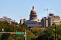
21 | Capital of Texas Highway | A scenic overlook on the east side of Capital of Texas Highway in West Lake Hills, Texas | Stationary, Dramatic Glimpse | 5.7 miles (9.2 km) | |
22 | 38th Street at Red River | Southbound lanes of Red River Street around its intersection with 38th Street [f] | Sustained Approach | 1.8 miles (2.9 km) | |
23 | Robert Mueller Airport | Base of the old air traffic control tower at the former Mueller Airport [g] | Stationary | 2.7 miles (4.3 km) | |
24 | Martin Luther King, Jr. Boulevard at Interstate Highway 35 | Westbound lanes of Martin Luther King, Jr. Boulevard at its intersection with I-35 | Threshold | 3,500 feet (1,100 m) | ![]() |
25 | Oakwood Cemetery | Comal Street as it runs through Oakwood Cemetery | Stationary | 5,000 feet (1,500 m) | ![]() |
26 | East 12th Street at Interstate Highway 35 | East 12th Street's elevated crossing over I-35 | Threshold | 3,100 feet (940 m) | ![]() |
27 | Lyndon Baines Johnson Library | Terrace of the Lyndon Baines Johnson Library and Museum on the University of Texas campus [f] [h] | Stationary | 1.0 mile (1.6 km) | |
28 | North Congress Avenue at Martin Luther King, Jr. Boulevard | North Congress Avenue from its intersection with Martin Luther King, Jr. Boulevard at the southern edge of the University of Texas campus [h] | Stationary | 2,300 feet (700 m) | ![]() |
29 | Field Level of the Memorial Stadium Practice Center | Practice field to the south of Darrell K Royal–Texas Memorial Stadium on the University of Texas campus [h] | Stationary | 3,600 feet (1,100 m) | |
30 | Entrance Terrace to the University of Texas Swim Center | Terrace of the Lee and Joe Jamail Texas Swimming Center on the University of Texas campus [h] | Stationary | 2,900 feet (880 m) | ![]() |
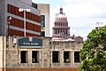
[a] ^ The state and city definitions of this corridor disagree, with the state defining a longer section of the bridge as the protected viewpoint.
[b] ^ The state and city definitions of this corridor disagree, with the state defining a point just downstream from the bridge as the protected viewpoint.
[c] ^ The state and city definitions of this corridor disagree, with the city defining a longer section of the highway as the protected viewpoint.
[d] ^ The state and city definitions of this corridor disagree, with the state defining a wider protected viewpoint, slightly farther north (closer to the lake).
[e] ^ The state and city definitions of this corridor disagree, with the city defining a wider protected viewpoint.
[f] ^ This corridor was partially obstructed by the addition of an upper seating deck to the east side of Darrell K Royal–Texas Memorial Stadium.
[g] ^ Redevelopment of the airport has been exempted from compliance with this viewing corridor.
[h] ^ This corridor is defined only under state law (not under city ordinance).
In February 2017, the Austin City Council considered a proposal to designate additional protected viewing corridors in east Austin. [16] The proposal was provisionally approved by council on February 16, after an amendment removed one of the five proposed new corridors; [25] that corridor was later restored to the proposal on March 2. [26] As of 2020 [update] , city staff are reviewing the proposed additional corridors for feasibility. [27]
Number | Name | Viewpoint | Type of view | Length | Image |
---|---|---|---|---|---|
1 | Rosewood Park and Thompson Street | Thompson Street across Rosewood Park | Threshold | 1.9 miles (3.1 km) | ![]() |
2 | Lott Park | Lott Park | Stationary | 3,500 feet (1,100 m) | |
3 | Texas State Cemetery | A hillside within the Texas State Cemetery | Stationary | 1.1 miles (1.8 km) | |
4 | Juniper and Navasota | Intersection of Juniper Street and Navasota Street | Threshold | 4,600 feet (1,400 m) | ![]() |
5 | Huston–Tillotson University | Jackson Moody Building on the Huston–Tillotson University campus | Stationary | 1.3 miles (2.1 km) |
Austin is the capital city of the U.S. state of Texas, as well as the seat and most populous city of Travis County, with portions extending into Hays and Williamson counties. Incorporated on December 27, 1839, it is the 10th most populous city in the United States, the fourth most populous city in Texas, and the second most populous state capital city. It has been one of the fastest growing large cities in the United States since 2010. Downtown Austin and Downtown San Antonio are approximately 80 miles (129 km) apart, and both fall along the Interstate 35 corridor. This combined metropolitan region of San Antonio–Austin has approximately 5 million people. Austin is the southernmost state capital in the contiguous United States and is considered a Beta-level global city as categorized by the Globalization and World Cities Research Network.
The Texas State Capitol is the capitol and seat of government of the American state of Texas. Located in downtown Austin, Texas, the structure houses the offices and chambers of the Texas Legislature and of the Governor of Texas. Designed in 1881 by architect Elijah E. Myers, it was constructed from 1882 to 1888 under the direction of civil engineer Reuben Lindsay Walker. A $75 million underground extension was completed in 1993. The building was added to the National Register of Historic Places in 1970 and recognized as a National Historic Landmark in 1986.
The Lyndon Baines Johnson Library and Museum, also known as the LBJ Presidential Library, is the presidential library and museum of Lyndon Baines Johnson, the 36th president of the United States (1963–1969). It is located on the grounds of the University of Texas at Austin, and is one of 13 presidential libraries administered by the National Archives and Records Administration. The LBJ Library houses 45 million pages of historical documents, including the papers of President Johnson and those of his close associates and others.
A protected view or protected vista is the legal requirement within urban planning to preserve the view of a specific place or historic building from another location. The effect of a protected view is to limit the height of new buildings within or adjacent to the sightline between the two places so as to preserve the ability to see the landmark as a focus of the view. The protection may also cover the area behind the place or building concerned.
Loop 1 is a freeway which provides access to the west side of Austin in the U.S. state of Texas. It is named Mopac Expressway after the Missouri Pacific Railroad. Local residents almost always use the name "MoPac" rather than calling the road by its number, which can cause much confusion, for few signs along the road use this name.
Congress Avenue is a major thoroughfare in Austin, Texas. The street is a six-lane, tree lined avenue that cuts through the middle of the city from far south Austin and goes over Lady Bird Lake leading to the Texas State Capitol in the heart of Downtown.
Capital MetroRail is a hybrid rail system that serves the Greater Austin area in Texas and is owned by Capital Metro, Austin's primary public transportation provider. The Red Line is Capital Metro's first and currently only rail line, and connects Downtown Austin with Austin's northwestern suburbs. The line operates on 32 miles (51 km) of existing freight tracks, and serves nine stations. After a series of delays, Capital MetroRail was inaugurated in March 2010. Capital Metro added Friday evening and Saturday afternoon and evening regularly scheduled service on March 23, 2012. In 2022, the line had a ridership of 466,800, or about 1,500 per weekday as of the third quarter of 2023.
The Lee and Joe Jamail Texas Swimming Center is an aquatics facility at the University of Texas at Austin in the USA. It is home to the university's swimming and diving teams, a variety of university-offered swimming and scuba-diving classes, as well as Longhorn Aquatics, a youth program. The facility also hosts the annual State high school championships in swimming and diving, run by the University Interscholastic League.
Oakwood Cemetery, originally called City Cemetery, is the oldest city-owned cemetery in Austin, Texas. Situated on a hill just east of I-35 that overlooks downtown Austin, just north of the Swedish Hill Historic District and south of Disch-Falk Field, the once-isolated site is now in the center of the city.
The French Legation is a historic legation building in eastern Austin, Texas, built in 1841 to represent the French government in the new Republic of Texas.
Wooldridge Park, also known as Wooldridge Square, is an urban park in downtown Austin, Texas. The park consists of a city block containing a natural basin whose sides slope inward to form an amphitheater with a bandstand at its center. The park was added to the National Register of Historic Places in 1979.
The 360 Residential Condominiums skyscraper is located in Downtown Austin, Texas at 360 Nueces Street. The building itself stands 581 ft (177 m) tall with 44 floors, 430 condos, and over 14,000 sq ft (1,300 m2) of retail space. The building topped out in November 2007, and construction was officially completed on May 22, 2008. 360 Condominiums was the tallest building in Austin from January 15, 2008 to June 29, 2009 when The Austonian surpassed it. The tower also became the tallest residential tower in Texas, surpassing The Merc in Dallas before the Austonian also took that title. Currently, it is the fourth tallest building in Austin after The Independent, The Austonian, and the Fairmont Austin.
Downtown Austin is the central business district of Austin, Texas, United States. The area of the district is bound by Lamar Boulevard to the west, Martin Luther King Jr. Boulevard to the north, Interstate 35 to the east, and Lady Bird Lake to the south.
Robert Mueller Municipal Airport(IATA: AUS, ICAO: KAUS, FAA LID: AUS) was the first civilian airport built in Austin, Texas, United States. It was located a few miles northeast of downtown Austin. It was replaced as Greater Austin's main airport by the Austin–Bergstrom International Airport, which is located on the site of the former Bergstrom Air Force Base. The airport was named after Robert Mueller, a city commissioner who died in office in January 1927. Robert Mueller Municipal Airport was identified with the airport code AUS, which was reassigned to Austin–Bergstrom International Airport in 1999.
East Riverside-Oltorf is a neighborhood in Austin, Texas, located southeast of the city's urban core. The East Riverside, Parker Lane, and Pleasant Valley neighborhoods together form the East Riverside-Oltorf Combined Neighborhood Planning Area. The region is bounded on the north by Lake Lady Bird, to the east by Grove Boulevard and the Montopolis neighborhood, Texas State Highway 71 to the south, and Interstate 35 and South River City to the west.
Society for the Preservation of Downtown Los Angeles, also known as SP-DTLA, is a 501(c)(3) organization that advocates what it characterizes as responsible and respectful development around and among Downtown Los Angeles' historic structures. SP-DTLA supports development with a positive impact on the designated Los Angeles Historic-Cultural Monuments in Downtown Los Angeles, especially those in the Historic Core.
The Westgate Tower is a mixed-use high-rise building in downtown Austin, Texas. The twenty-six-story 261-foot (80 m) tower block was designed in 1962 and completed in 1966; its name reflects its location across the street from the west gate of the Texas State Capitol. Designed by architect Edward Durell Stone, the tower was added to the National Register of Historic Places in 2010 and designated a Recorded Texas Historic Landmark in 2012.
Gregorio Eduardo Casar is an American politician who is the member for Texas's 35th congressional district in the United States Congress since 2023. He served as a member of the Austin City Council from the 4th district from 2015 to 2022. Casar is a member of the Democratic Party and was endorsed by the Working Families Party in his run for Congress. Casar is an unendorsed member of the Democratic Socialists of America. He was first elected to the Austin City Council in 2014, and reelected in 2016 and 2020. He was elected to Congress in 2022.
The 1928 Austin city plan was commissioned in 1927 by the City Council of Austin, Texas. It was developed by consulting firm Koch & Fowler, which presented the final proposal early the next year. The major recommendations of this city plan related to Austin's street plan, its zoning code, and the development of major industries and civic features, but it is most remembered for institutionalizing housing segregation by designating East Austin as the city's negro district.