Old West Austin Historic District

Last updated
Old West Austin Historic District and Boundary Increase
Woodlawn austin 2006.jpg
Woodlawn, the oldest home in the district
Old West Austin Historic District
Location Austin, Texas
Coordinates 30°15′49″N97°46′36″W / 30.26361°N 97.77667°W / 30.26361; -97.77667 Coordinates: 30°15′49″N97°46′36″W / 30.26361°N 97.77667°W / 30.26361; -97.77667
Area6500 acres
Built1853
NRHP reference No. 03000937; 03001413 [1]
Added to NRHPSeptember 12, 2003; January 16, 2004

The Old West Austin Historic District is a residential community in Austin, Texas, United States. It is composed of three neighborhoods located on a plateau just west of downtown Austin: Old Enfield, Pemberton Heights, and Bryker Woods. Developed between 1886 and 1953, the three historic neighborhoods stretch from Mopac Expressway east to Lamar Boulevard, and from 13th Street north to 35th Street. It borders Clarksville Historic District and the West Line Historic District to the south. [2]

Contents

The streetcar had propelled Austin's earlier local suburban development, but Enfield, Pemberton Heights, and Bryker Woods were the city's first automobile suburbs. As a well-preserved collection of early-to-mid-20th century residences, the historic district evokes the measured spread of suburban development that paralleled the city's steady growth. The three neighborhoods that together form Old West Austin were added to the National Register of Historic Places in 2003. [3]

Settlement of Old West Austin

For much of the 19th century, Shoal Creek and West Avenue defined the western edge of the city. Austin was planned on a 640-acre site on a bluff above the Colorado River, nestled between Shoal Creek (West Avenue) to the west and Waller Creek (East Avenue) to the east Edwin Waller in 1839. [4] The story of the settlement of Old West Austin begins with the oldest and best-known home in the area, Woodlawn. James B. Shaw, an Irish immigrant who served as State Comptroller in Texas Governor Elisha M. Pease's administration, purchased several hundred acres of land west of Austin in 1846. [5]

Shaw commissioned Austin architect Abner Cook to build a two-story Greek Revival mansion on his property. The house was finished in 1853, one year before Cook built the Texas Governor's Mansion. Almost as soon as the building was completed Shaw abandoned the idea of living there because of family tragedies. In 1856, Governor Pease bought Woodlawn, and it remained in his family for nearly fifty years. [6] Woodlawn's adjoining acreage would eventually be sold and subdivided to create the Enfield neighborhood.

Following emancipation at end of the Civil War, Texas Governor Pease sold and gave some of his plantation land to his freed black slaves. In 1871 this neighboring area came to be known as Clarksville and was legally set apart from the other areas of town specifically for the freed black slaves.

It was called Clarksville because Charles (Griffin) Clark, a land developer with an eye to reselling to the newly freed slaves, purchased a 365-acre (1.48 km2)tract of land from former slaves where he founded the town of Clarksville, less than one-half mile from Woodlawn. [7]

Other important West Austin developments during the 1870s included the establishment of the International and Great Northern Railroad, which defines the historic district's western boundary, and the establishment of Pease Park, which define the district's eastern boundary. The land was donated to the city by the Pease family. Shoal Creek is the centerpiece of Pease Park. The waterway attracted recreational use as early as the mid-nineteenth century.

Old Enfield

The oldest and southernmost neighborhood in the historic district is Old Enfield. Its approximate boundaries are Windsor Road on the north, Pease Park on the east, 13th Street to the south, and the Mo-Pac Expressway on the west. Originally part of the Pease family's plantation just west of Austin, the neighborhood was subdivided in 1910 by the Enfield Realty and Home Building Company. Old Enfield is home to many of the oldest colonial style-homes in Austin, including Woodlawn which was built by Texas Governor's Mansion architect Abner Cook.

Additionally, Old Enfield encompasses several additions platted between 1914 and 1948. Two later additions were platted on the west side of the historic district after 1948. The plan for Old Enfield is largely intact incorporating several small island parks along curvilinear streets at the edge of Pease Park.

Pemberton Heights

Due north of Old Enfield is the suburb of Pemberton Heights. The area that would become Pemberton Heights was acquired in 1858 by Judge John Harris, who was the attorney general for Governor Pease and husband of the daughter of Samuel Rhoads Fisher, a signer of the Texas Declaration of Independence. S.W. Fisher, president of the Austin Development Company, also became an owner and ultimately developed the land. The subdivision was named after James Pemberton (1723–1809), an ancestor of the Fischer family who received notoriety because of his political views during the days of the American colonies. The Fisher family went on to inherit the farm and would establish the Austin Land Company. In 1927, the company built a bridge across Shoal Creek and began development. [8]

Between 1927 and the early 1940s, Pemberton Heights was developed in 12 sections. Pemberton Heights is primarily one to two-story single-family residences and not as many duplexes as the other neighborhoods. It has, on average, the largest houses and most spacious lots in the Old West Austin Historic District.

Over 25 structures in Pemberton Heights have been designated as Austin Historic Landmarks by the City Council including the Windsor Road Bridge, which was built in 1928. Its importance stems not only from its architectural merit, but also because prior to its construction, Pemberton Heights and other Old West Austin area residents could only access downtown by crossing Shoal Creek on the State Street Bridge, which is now a pedestrian bridge adjacent to the 34th Street Bridge.

Bryker Woods

Bryker Woods is the northernmost suburb of the Old West Austin Historic District. The suburb encompasses several parcels of land that were platted between 1886 and 1951. Bryker Woods experienced intense development between 1936 and 1940.

By the late 1990s, the State of Texas began exploring improvement and expansion of Mopac Expressway. By 2000, Bryker Woods, Pemberton Heights, Old Enfield, and Old West Austin neighborhoods organized because of concerns over the potential expansion of Loop 1, which they believed would result in the demolition of as many as 80 houses. In 2003, they were successful in establishing the Old West Austin Historic District. One significant aspect of this historic designation is that federal law requires additional studies, review, and approval if using federal dollars on a project that could result in the demolition of properties in the district, which adds significant time and cost to the project. As federal dollars are needed for the expansion of Loop 1, this designation prevented the expansion of Loop 1 beyond its current right-of-way within these neighborhoods. [9]

Description and significance

The area is noted for approximately 1,574 historically significant properties within its borders.

List of significant properties

Several properties and sites in the Old West Austin Historic District have been designated as historic Austin landmarks by the city:

Related Research Articles

<span class="mw-page-title-main">Elisha M. Pease</span> American politician (1812–1883)

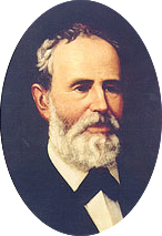
Elisha Marshall Pease was a Texas politician. He served as the fifth and 13th governor of Texas.

<span class="mw-page-title-main">Pease Park</span> Urban park in Austin, Texas

Pease Park is an urban park in central Austin, Texas. Paralleling Shoal Creek west of downtown, the park is frequented by University of Texas at Austin and Long-View Micro School students and, formerly, by disc golf enthusiasts. Every spring it plays host to the annual Eeyore's Birthday Party celebration, a favorite event for Austin's hippie subculture dating back to the 1960s.

<span class="mw-page-title-main">Woodlawn (Austin, Texas)</span> Historic house in Texas, United States

Woodlawn, also known as the Pease Mansion as well as Governor Shiver's Mansion, is a pre-Civil War mansion located at 30.2871° -97.7581° in Austin, Texas. The Greek Revival style house was owned by two Texas governors. Some notable people that have visited the mansion include Sam Houston, General George Custer, Elisabet Ney, Will Rogers, and Edith Head. Woodlawn was added to the National Register of Historic Places on August 25, 1970.

<span class="mw-page-title-main">Tarrytown, Austin, Texas</span> Neighborhood of Austin, Texas

Tarrytown is a neighborhood located west of Downtown Austin, Texas. The neighborhood is bordered by Lake Austin Boulevard on the south, Lake Austin on the west, West 35th Street on the north and Mopac Expressway on the east. Major roads in the area include Exposition Boulevard, Enfield Road and Windsor Road. Tarrytown also encompasses the sub-neighborhood of Brown Herman.

<span class="mw-page-title-main">Clarksville Historic District (Austin, Texas)</span> Historic district in Texas, United States

The Clarksville Historic District in Austin, Texas, is an area located west of downtown Austin near Lady Bird Lake and just northeast of the intersection of the Missouri Pacific Railroad and West Tenth Street. Many historic homes and structures are located within the Clarksville Historic District. While Clarksville is geographically part of the Old West Austin Historic District, it is distinct from the two historic neighborhoods of Old Enfield, which lies immediately to the north on the eastern side of Texas State Highway Loop 1, and Tarrytown, which is situated to the west and northwest on the western side of Mopac.

The Ethel Felder Webster House is a historic two-story home in the Enfield historic district in Austin, Texas. The home was built in 1917 and was among the first five built on Enfield Road. All were completed by 1918 and are listed in the city directory for that year. It is the only surviving house of these originals.

<span class="mw-page-title-main">Downtown Austin</span> Neighborhood in Austin, Texas

Downtown Austin is the central business district of Austin, Texas. The area of the district is bound by Lamar Boulevard to the west, Martin Luther King Jr. Boulevard to the north, Interstate 35 to the east, and Lady Bird Lake to the south.

North Shoal Creek is a neighborhood in north central Austin, Texas established in the 1960s.

Allandale, Austin, Texas is a neighborhood in North Central Austin, in the U.S. State of Texas known for its large lots, mature trees, and central location.

<span class="mw-page-title-main">Bryker Woods, Austin, Texas</span>

Bryker Woods is an older Austin, Texas, central city neighborhood developed in the 1930s, the center of which is approximately located at 30°18′17″N97°45′06″W. It is predominantly a mix of young and old families and zoned as a single-family neighborhood composed of mostly small homes in good condition, most of which are over 50 years old. The Bryker Woods neighborhood is also part of the Old West Austin Historic District. Bryker Woods has its own elementary school, Bryker Woods Elementary, and is convenient to retail and recreational facilities.

<span class="mw-page-title-main">West Line Historic District (Austin, Texas)</span> Historic district in Texas, United States

The West Line Historic District is a residential community in central Austin, Texas, United States. The district encompasses an approximately 90-block tract of land located west of downtown. Bounded by Baylor Street to the east, Fifth Street to the south, Thirteenth Street to the north and Texas State Highway Loop 1 to the west. It is located south of the Old West Austin Historic District and southeast of the Clarksville Historic District.

<span class="mw-page-title-main">Montopolis, Austin, Texas</span> Neighborhood in Austin, Texas, United States

Travis County has had two locations named Montopolis. The first was during the Republic of Texas period north of the Colorado River. Today's Montopolis is a neighborhood in Austin, Texas south of the river. Located southeast of the city's urban core, today's neighborhood is in ZIP code 78741. Montopolis is bounded by Lake Lady Bird on the north, by Grove Street and the Pleasant Valley neighborhood on the west, to the south by Texas State Highway 71, and by U.S. Route 183 on the east. The southeast corner abuts Austin-Bergstrom International Airport. Montopolis is in City Council District 3.

South River City is a community located in Austin, Texas. Also frequently called Travis Heights, the neighborhood is located south of the city's urban core, just below Lake Lady Bird in South Austin. The area encompasses a portion of ZIP code 78704.

Splitrock is a house in Austin, Texas, built in 1893 by a Scottish immigrant named Robert F Burns. Located at 2815 Wooldridge Dr. on bluffs overlooking Shoal Creek, the house was one of the first in the central Austin area which is now occupied by the Pemberton Heights and Bryker Woods neighborhoods. The name Splitrock is derived from a topographic feature and swimming hole located approximately 300 feet (91 m) south east of the house. In 2006 Splitrock was designated as a City of Austin Historic Landmark. The house also referred to as the “Burns-Klein” house is a contributing property to the Old West Austin National Register Historic District.

<span class="mw-page-title-main">Pemberton Heights, Austin, Texas</span>

Pemberton Heights is a neighborhood of Austin, Texas, and part of the Old West Austin Historic District. The area is bounded by Northwood Road on the north, Lamar Boulevard/Shoal Creek on the east, 24th Street/Windsor Road on the south, and Texas State Highway Loop 1 ("MoPac") on the west. It is Austin's wealthiest and most historic neighborhood.

<span class="mw-page-title-main">Shoal Creek, Austin, Texas</span> River in the United States

Shoal Creek is a stream and an urban watershed in Austin, Texas, United States.

<span class="mw-page-title-main">West Fifth Street Bridge at Shoal Creek</span> Historic bridge in Austin, Texas

The West Fifth Street Bridge is a historic cantilever concrete girder bridge in downtown Austin, Texas. Built in 1931, the bridge carries Fifth Street across Shoal Creek to link central Austin with neighborhoods that were then the city's western suburbs. It is one of only a handful of curved cantilever girder bridges in Texas, built as part of the city's 1928 master plan for urban development and beautification. The bridge was added to the National Register of Historic Places in 2019.

<span class="mw-page-title-main">1928 Austin city plan</span> Plan commissioned by Austin City Council

The 1928 Austin city plan was commissioned in 1927 by the City Council of Austin, Texas. It was developed by consulting firm Koch & Fowler, which presented the final proposal early the next year. The major recommendations of this city plan related to Austin's street plan, its zoning code, and the development of major industries and civic features, but it is most remembered for institutionalizing housing segregation by designating East Austin as the city's negro district.

<span class="mw-page-title-main">Third Street Railroad Trestle</span> Historic railroad bridge in downtown Austin, Texas

The Third Street Railroad Trestle is a historic wooden railroad trestle bridge crossing Shoal Creek in downtown Austin, Texas. Built around 1922 by the International–Great Northern Railroad, it replaced an earlier bridge in the same place. The bridge was used by the I–GN Railroad, the Missouri Pacific Railroad, and the Missouri–Kansas–Texas Railroad until 1964, when commercial rail traffic stopped; after 1991 the bridge was abandoned. It was added to the National Register of Historic Places in 2021.

References

  1. "NRHP nomination form" (PDF). Texas Historical Commission.
  2. "Old West Austin Historic District". Texas Historical Site Atlas. Archived from the original on 2014-07-14. Retrieved Sep 8, 2011.
  3. "Travis County, Texas". National Register of Historical Places. Retrieved Sep 8, 2011.
  4. Charles D., Spurlin. Waller, Edwin. Handbook of Texas. Retrieved Sep 6, 2011.
  5. Griffin, Roger. "Pease, Elisha Marshall". Handbook of Texas Online. Retrieved Sep 8, 2011.
  6. Kafertepe, Kenneth. "Cook, Abner H." Handbook of Texas Online. Retrieved Sep 10, 2011.
  7. Thompson, Nolan. "Clarksville, YX (Travis County)". Handbook of Texas Online. Retrieved January 2, 2011.
  8. "Shoal Creek (Travis County)". The Handbook of Texas Online. Retrieved Sep 8, 2011.
  9. "Central West Austin Neighborhood Plan". Old West Austin Neighborhood Association. Retrieved Sep 8, 2011.