
A rock shelter — also rockhouse, crepuscular cave, bluff shelter, or abri — is a shallow cave-like opening at the base of a bluff or cliff. In contrast to solutional cave (karst) caves, which are often many miles long, rock shelters are almost always modest in size and extent.

Enchanted Rock is a pink granite mountain located in the Llano Uplift approximately 17 miles (27 km) north of Fredericksburg, Texas and 24 miles (39 km) south of Llano, Texas, United States. Enchanted Rock State Natural Area, which includes Enchanted Rock and surrounding land, spans the border between Gillespie County and Llano County, south of the Llano River. Enchanted Rock covers approximately 640 acres (260 ha) and rises approximately 425 feet (130 m) above the surrounding terrain to elevation of 1,825 feet (556 m) above sea level. It is the largest pink granite monadnock in the United States. Enchanted Rock State Natural Area, a part of the Texas state park system, includes 1,644 acres (665 ha). Designated a Recorded Texas Historic Landmark in 1936.
Meadowcroft Rockshelter is an archaeological site located near Avella in Jefferson Township, Washington County, Pennsylvania, United States. The site is a rock shelter in a bluff overlooking Cross Creek, and contains evidence that the area may have been continually inhabited for more than 19,000 years. If accurately dated, the site would be the earliest known evidence of human presence and the longest sequence of continuous human occupation in the New World.

Arrow Rock State Historic Site is an open-air museum encompassing a geographic formation and a portion of the village of Arrow Rock, Missouri. The park is part of the Arrow Rock Historic District, a National Historic Landmark, and commemorates the history of the area as a key stop on the Santa Fe Trail.
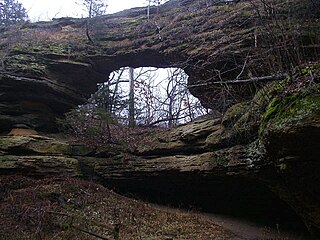
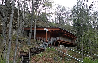
Natural Bridge State Park is a 530-acre (214 ha) state park of Wisconsin, United States, featuring Wisconsin's largest natural arch. Directly beneath the arch is the Raddatz Rockshelter, a rock shelter once used by Paleo-Indians and now listed on the National Register of Historic Places. The park is located southwest of Baraboo between the unincorporated communities of Leland and Denzer, in the town of Honey Creek.

Table Rock State Park is a 3,083-acre (12.48 km2) park at the edge of the Blue Ridge Mountains in northern Pickens County, South Carolina. The park includes Pinnacle Mountain, the tallest mountain totally within the state.

Austin–Round Rock is a five-county metropolitan area in the U.S. state of Texas, as defined by the Office of Management and Budget. Commonly referred to as Greater Austin, the metropolitan area is situated in Central Texas on the eastern edge of the American Southwest, and borders San Antonio–New Braunfels to the south.

Mile Canyon or more recently known as Eagle Nest Canyon is a tributary canyon of the Rio Grande entering on the north side of the river just downstream from Langtry, Texas. Mile Canyon received its name due to its length being approximately one mile long. In more recent years, this canyon is more commonly referred to as Eagle Nest Canyon, named after a nesting pair of golden eagles observed nearby. It has been an important area of many archaeological and geological expeditions over the past century.
Agger Rockshelter is a prehistoric rock shelter located in Stevenstown, in La Crosse County, Wisconsin, United States. The shelter faces west and overlooks a tributary of the Black river. During the 1980s and 1990s the Mississippi Valley Archaeology Center conducted an extensive survey of the Driftless area which led to the discovery of unrecorded rock art.

Gatecliff Rockshelter (26NY301) is a major archaeological site in the Great Basin area of the western United States that provides remarkable stratigraphy; it has been called the "deepest archaeological rock shelter in the Americas". Located in Mill Canyon of the Toquima Range in the Monitor Valley of central Nevada, Gatecliff Rockshelter has an elevation of 7,750 feet (2,360 m). David Hurst Thomas discovered Gatecliff Rockshelter in 1970 and began excavations in 1971. Full scale excavations occurred at Gatecliff Rockshelter for about seven field seasons in which nearly 33 feet (10 m) of sediments were exposed for a well-defined stratigraphic sequence. The well-preserved artifacts and undisturbed sediments at Gatecliff Rockshelter provides data and information have been applied to a range of research topics. Based on the analysis of the artifacts at Gatecliff Rockshelter, it can be determined that it was most likely a short-term field camp throughout prehistory. The latest evidence for human usage at Gatecliff occurs between ca. 5500 B.P. to 1250 B.P.

The Tomaquag Rock Shelters (RI-HP-1) are a rockshelter site off Maxson Hill Road in Hopkinton, Rhode Island. The shelters are located under two east-facing granite outcrops in the valley drained by Tomaquag Brook. First discovered in the late 1950s by Nathan Kaye, materials recovered from test excavations resulted in the dating the occupation of one shelter to 800 BCE and the other to 800 CE. Materials recovered include projectile points, stone knives, and evidence of stone tool construction. Both sites included evidence pointing to the presence of a fire pit.

The Rockrimmon Rockshelter is an archeological site in Stamford, Connecticut that was listed on the National Register of Historic Places in 1994. The site is significant as an early Native American shelter and is centered on a boulder about 60 feet high that was used as the shelter. Native American tools and points were discovered at the site during excavations in 1975 and 1980.

Confederate Reunion Grounds is a Texas historic site located near Mexia, Limestone County, Texas at the confluence of the Navasota River and Jack’s Creek. From 1889–1946, Confederate Civil War veterans and families reunited at the site during late-July or early-August, camping under the giant bur oaks, enjoying speeches, concerts, dances, fellowship and food, and raising funds for families of their fallen comrades.

Seminole State Park and Historic Site is located on US Route 90, east of the Pecos River High Bridge, 9 miles (14 km) west of Comstock in Val Verde County in the U.S. state of Texas. The park is conducive to camping, biking, bird watching, back packing and archeological study. Cave art and archeological artifacts date back to the earliest human habitation in the area. The park is part of the larger Seminole Canyon Archeological District on the National Register of Historic Places listings in Val Verde County, Texas.
The Cherry Creek Rockshelter is an archaeological site in central Colorado, located within modern-day Castlewood Canyon State Park near Franktown, Colorado. Current research indicates that it was used by Native American inhabitants beginning in the Archaic period. The site is situated on the Palmer Divide, which allowed for a unique prehistoric environment that contributed to an abundance of food and water sources, as well as lithic materials for tool-making. These factors, combined with the structure and situation of the shelter itself, made the site a particularly attractive environment for prehistoric peoples to settle in. Archaeological study of the site began in 1955, with the most current original research concluding in 2002.

The Rockhouse Cliffs Rockshelters are a pair of rockshelters in the far southern region of the U.S. state of Indiana. Located amid broken terrain in the Hoosier National Forest, the shelters may have been inhabited for more than ten thousand years by peoples ranging from the Early Archaic period until the twentieth century. As a result of their extensive occupation and their remote location, they are important and well-preserved archaeological sites and have been named a historic site.
Craig Run East Fork Rockshelter is a historic archaeological site located near Mills Mountain, Webster County, West Virginia. It is one of a number of prehistoric rock shelters on the Gauley Ranger District, Monongahela National Forest, that are known to have been utilized prehistorically from the Middle Archaic through the Late Woodland period, c. 6000 B.C. – 1200 A.D. In more recent history, the Craig Run rock shelter is known to have served as a stable for a donkey which was employed in the locust post industry.
Laurel Run Rockshelter is a historic archaeological site located near Coe, Webster County, West Virginia. It is one of a number of prehistoric rock shelters on the Gauley Ranger District, Monongahela National Forest, that are known to have been utilized prehistorically from the Middle Archaic through the Late Woodland period, c. 6000 B.C.-1200 A.D. There are some indications that the Laurel Run rock shelter may have been utilized during the Early Archaic period, c. 8000-6000 B. C.

The Hidden Valley Rockshelter (44-BA-31) is a significant archaeological site located near the community of Warm Springs in Bath County, Virginia, United States. A large rockshelter located near the Jackson River, it has been occupied by humans for thousands of years, and it has been named a historic site.


