Lockhart State Park

Last updated

Lockhart State Park
Lockhart state park combination building.jpg
The Lockhart State Park Recreation Hall. The building was designed by Olin Smith and constructed by Civilian Conservation Corps Company 3803 circa 1936.
Relief map of Texas.png
Red pog.svg
Usa edcp relief location map.png
Red pog.svg
Location Caldwell County, Texas
Nearest city Lockhart
Coordinates 29°51′19″N97°41′52″W / 29.85528°N 97.69778°W / 29.85528; -97.69778
Area263.7 acres (107 ha)
Established1948
Visitors57,558(in 2022) [1]
Governing body Texas Parks and Wildlife Department

Lockhart State Park is a state park located at the southwestern edge of Lockhart, Texas, United States and is administered by the Texas Parks and Wildlife Department. The park was constructed by Civilian Conservation Corps (CCC) Company 3803 between 1935 and 1938. The park officially became a state park in 1948. [2]

Contents

History

Native Americans occupied this area long before it was a park. [3] As was the case in much of the Americas, it was not long before conflict between settlers and Native Americans arose. Shortly after Texas independence in 1840, as retaliation for the Council House Fight, a large contingent of Comanches, led by the Penateka Comanche War Chief Buffalo Hump, raided, plundered, and burned towns and homesteads from the Guadalupe River valley southwards to the coast at Matagorda Bay. [3]

On their eventual withdrawal, a volunteer army of Texas militia, allied Tonkawa, and Texas Rangers overtook the Comanche near the present town of Lockhart. The famous Battle of Plum Creek took place just a few miles north of the park; informative panels within the park detail its history and events. [3] The battle was more of a running gun fight than a staged battle in the traditional sense. As the larger Comanche raiding party attempted to escape with their plundered goods and livestock, warriors engaged in rearguard skirmishes with the pursuing militia.

In purely military terms, it is arguable whether there was a victor in the battle, as the Comanche escaped with the majority of their plunder, while an unverifiable number of casualties was reported. What is notable about the battle is that it marked the last large scale Comanche raid to venture beyond the Texan frontier.

Construction

The park consists of 263.7 acres of land along the Clear Fork of the Plum Creek that was purchased by the State of Texas from Henry Masur on December 14, 1934. [4] The land was set aside for the express purpose of creating public recreational facilities by the men of the Civilian Conservation Corps (CCC). [5]

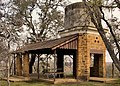
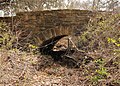
Work on the park began in 1935 by Company 3803. The design plan called for stonework and timber beam construction in a style reminiscent of early Texas frontier homesteads. Examples include the park's residence building, the recreation hall, a stone arch bridge, an elevated concrete water storage tank, a series of stone dams, stone trail head steps, culverts, picnic tables, and outdoor fire rings. A swimming pool was also built along the banks of Clear Fork Creek, but due to routine flooding of the creek, the original swimming pool was filled in and a new swimming pool built uphill from the creek in 1970's. Finally, a 9-hole golf course was planned for in the original blueprints of the park, but because the CCC was limited to work of a conservational nature, that project was reserved for another New Deal program, the Works Progress Administration (WPA). [5] The CCC did clear the land for the golf course project.

Construction of the park was completed by the CCC in 1938; the golf course was completed by 1941. After completion, the park was initially leased to a local country club until 1948, when it was officially opened to the public as a state park. [4]

Features

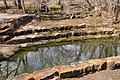
Clear Fork Creek, a tributary of the larger Plum Creek, runs through the middle of the park. A series of small stone check dams were constructed by the CCC to provide areas for recreational fishing. Fish species tend to be bass, catfish, and sunfish. A free loaner pole and tackle program is available within the park.

The park features roughly four miles of designated trails that cover a wide range of environments. In addition to multiple short, shade covered trails along the creek in a riparian zone, a network of natural trails traversing multiple hillsides and ravines is located on the backside of the park. A moderate degree of elevation change can be experienced, but no trails are rated higher than moderate difficulty. Mountain biking is allowed on designated trails. Other activities include picnicking, camping, swimming, and golfing.

Animals

White-tailed deer are the most frequently spotted creatures in the park, but raccoon, opossum, nine-banded armadillo, nutria, beaver, rabbit, fox squirrel, coyote, bobcat, and fox also call the park home. Wild turkey are also sighted occasionally. Hikers need to be wary of the parks two most dangerous inhabitants, rattlesnakes and coral snakes. Invasive species such as feral pig have caused the park a great deal of damage and, while not welcomed, are common.

Flora

Trees in the park include Texas red oak, Texas kidneywood, eastern red cedar, honey mesquite, Mexican plum, Hercules' club, live oak, black walnut, and Texas persimmon. Shrubs like elbow bush, chile pequin, Texas lantana, rusty blackhaw, Spanish dagger and fragrant sumac flourish in the rich soil along with plants such as Turk's cap, Virginia creeper and several species of greenbriar. Plains prickly pear and tasajillo cactus and native grasses such as little bluestem can be found in open areas.

See also

Related Research Articles

<span class="mw-page-title-main">Petit Jean State Park</span> United States historic place

Petit Jean State Park is a 3,471-acre (1,405 ha) park in Conway County, Arkansas managed by the Arkansas Department of Parks and Tourism. It is located atop Petit Jean Mountain adjacent to the Arkansas River in the area between the Ouachita Mountains and Ozark Plateaus.

<span class="mw-page-title-main">Comanche Wars</span> Conflicts over Comanche lands, 1706 to 1870s

The Comanche Wars were a series of armed conflicts fought between Comanche peoples and Spanish, Mexican, and American militaries and civilians in the United States and Mexico from as early as 1706 until at least the mid-1870s. The Comanche were the Native American inhabitants of a large area known as Comancheria, which stretched across much of the southern Great Plains from Colorado and Kansas in the north through Oklahoma, Texas, and eastern New Mexico and into the Mexican state of Chihuahua in the south. For more than 150 years, the Comanche were the dominant native tribe in the region, known as “the Lords of the Southern Plains”, though they also shared parts of Comancheria with the Wichita, Kiowa, and Kiowa Apache and, after 1840, the southern Cheyenne and Arapaho.

<span class="mw-page-title-main">Abilene State Park</span> State park in Texas, United States

Abilene State Park is a 529.4-acre (214.2 ha) state park next to Lake Abilene about 15 miles (24 km) southwest of Abilene, Texas on FM 89. The park opened on May 10, 1934 and is managed by the Texas Parks and Wildlife Department.

<span class="mw-page-title-main">Tishomingo State Park</span> State park in Mississippi, United States

Tishomingo State Park is a public recreation area located in the foothills of the Appalachian Mountains in Tishomingo County, some 45 miles (72 km) northeast of Tupelo, Mississippi. The major feature of the park is Bear Creek Canyon and its generous sandstone outcroppings. Activities in the park include canoeing, rock climbing, fishing, and hiking. The park sits at Milepost 304 of Natchez Trace Parkway, a scenic road operated by the National Park Service that runs directly through the park.

<span class="mw-page-title-main">Cumberland Mountain State Park</span> State park in Tennessee, United States

Cumberland Mountain State Park is a state park in Cumberland County, Tennessee, in the southeastern United States. The park consists of 1,720 acres (7.0 km2) situated around Byrd Lake, a man-made lake created by the impoundment of Byrd Creek in the 1930s. The park is set amidst an environmental microcosm of the Cumberland Plateau and provides numerous recreational activities, including an 18-hole Bear Trace golf course.

<span class="mw-page-title-main">Worlds End State Park</span> Park in Sullivan County, Pennsylvania

Worlds End State Park is a 780-acre (316 ha) Pennsylvania state park in Sullivan County, Pennsylvania. The park, nearly surrounded by Loyalsock State Forest, is in the Loyalsock Creek valley on Pennsylvania Route 154 in Forks and Shrewsbury Townships southeast of the borough of Forksville. The name Worlds End has been used since at least 1872, but its origins are uncertain. Although it was founded as Worlds End State Forest Park by Governor Gifford Pinchot in 1932, the park was officially known as Whirls End State Forest Park from 1936 to 1943.

<span class="mw-page-title-main">Blue Knob State Park</span> State Park in Pennsylvania, United States

Blue Knob State Park is a 6,128-acre (2,480 ha) Pennsylvania state park in Kimmel, Lincoln, and Pavia townships in Bedford County, Pennsylvania, in the United States. The average annual snowfall at the park is about 12 feet (370 cm). The park is named for Blue Knob, the second highest mountain in Pennsylvania at 3,146 feet (959 m). It is the location of Blue Knob All Seasons Resort, the ski slope in Pennsylvania with the highest elevation. Blue Knob State Park is just off Interstate 99 on Pennsylvania Route 869 west of Pavia.

Buffalo Hump was a War Chief of the Penateka band of the Comanches. He came to prominence after the Council House Fight when he led the Comanches on the Great Raid of 1840.

<span class="mw-page-title-main">Fort Richardson (Texas)</span> State park and historic site in Texas, United States

Fort Richardson was a United States Army installation located in present-day Jacksboro, Texas. Named in honor of Union General Israel B. Richardson, who died in the Battle of Antietam during the American Civil War, it was active from 1867 to 1878. Today, the site, with a few surviving buildings, is called Fort Richardson State Park, Historic Site and Lost Creek Reservoir State Trailway. It was designated a National Historic Landmark in 1963 for its role in securing the state's northern frontier in the post-Civil War era.

<span class="mw-page-title-main">Bastrop State Park</span> State park and historic site in Texas, United States

Bastrop State Park is a state park in Bastrop County, Texas, United States. The park was established in 1933 and consists of stands of loblolly pines mixed with post oak and junipers.

<span class="mw-page-title-main">Palmetto State Park</span> State park in Texas, United States

Palmetto State Park is a state park located in Gonzales County, Texas, United States northwest of Gonzales and southeast of Luling. The land was acquired by deeds from private owners and the City of Gonzales in 1934–1936 and was opened in 1936.

<span class="mw-page-title-main">Backbone State Park</span> State park in Iowa

Backbone State Park is Iowa's oldest state park, dedicated in 1919. Located in the valley of the Maquoketa River, it is approximately three miles (5 km) south of Strawberry Point in Delaware County. It is named for a narrow and steep ridge of bedrock carved by a loop of the Maquoketa River originally known as the Devil's Backbone. The initial 1,200 acres (490 ha) were donated by E.M. Carr of Lamont, Iowa. Backbone Lake Dam, a relatively low dam built by the Civilian Conservation Corps (CCC) in the 1930s, created Backbone Lake. The CCC constructed a majority of trails and buildings which make up the park.

The Battle of Plum Creek was a clash between allied Tonkawa, militia, and Rangers of the Republic of Texas and a huge Comanche war party under Chief Buffalo Hump, which took place near Lockhart, Texas, on August 12, 1840, following the Great Raid of 1840 as the Comanche war party returned to west Texas.

<span class="mw-page-title-main">Great Raid of 1840</span> Largest raid mounted by Native Americans on white cities, now the US

The Great Raid of 1840 was the largest raid ever mounted by Native Americans on white cities in what is now the United States. It followed the Council House Fight, in which Republic of Texas officials attempted to capture and take prisoner 33 Comanche chiefs who had come to negotiate a peace treaty, killing them and capturing two dozen of their family and followers. The Comanche tribe was supposed to have brought white hostages as their part of the negotiations but brought only one young woman. Arguments and fighting then broke out among the Texans and Comanches. The Texas Officials were determined to force the Comanche to release all white captives among them. To avenge what the Comanche viewed as a bitter betrayal by the Texans, the Comanche war chief Buffalo Hump raised a huge war party of many of the bands of the Comanche, and raided deep into white-settled areas of Southeast Texas.

<span class="mw-page-title-main">Huntsville State Park</span> State park in Texas, United States

Huntsville State Park is a 2,083.2-acre (843 ha) wooded recreational area, six miles (10 km) southwest of Huntsville, Texas, within Walker County and the Sam Houston National Forest.

<span class="mw-page-title-main">Balmorhea State Park</span> State park in Texas, United States

Balmorhea State Park is a 46-acre (19 ha) state park located on the San Solomon Springs in Reeves County, Texas, opened in 1968. The closest city is Balmorhea, Texas. Texas Parks and Wildlife Department manages the park. The park is open year-round, and visitation is capped at 900 people per day.

<span class="mw-page-title-main">Devil's Den State Park</span> State park in Washington County, Arkansas, United States

Devil's Den State Park is a 2,500-acre (1,000 ha) Arkansas state park in Washington County, near West Fork, Arkansas in the United States. The park was built by the Civilian Conservation Corps, beginning in 1933. Devil's Den State Park is in the Lee Creek Valley in the Boston Mountains, which are the southwestern part of The Ozarks. The park, with an 8 acres (3.2 ha) CCC-built lake, is open for year-round recreation, with trails for hiking, mountain biking and horseback riding. Devil's Den State Park also has several picnic areas, a swimming pool and cabins, with camping sites ranging from modern to primitive. Fossils of coral and crinoids can be found along the banks and within Lee Creek at Devil's Den State Park.

<span class="mw-page-title-main">Bonham State Park</span> Protected area in Texas, US

Bonham State Park is a 261-acre (1.06 km2) state park located in Bonham, Texas. It includes a 65-acre (260,000 m2) lake, rolling prairies, and woodlands.

<span class="mw-page-title-main">Mission Tejas State Park</span> State park in Texas, United States

Mission Tejas State Park is a 660-acre (270 ha) state park located along Texas State Highway 21 in Houston County, Texas, originally constructed in 1935 and transferred to Texas Parks and Wildlife in 1957. The closest major town is Crockett, Texas. The park is open year-round.

Yellow Wolf, Spirit Talker 's nephew and Buffalo Hump 's cousin and best support, was a War Chief of the Penateka division of the Comanche Indians. He came to prominence after the Council House Fight, when Buffalo Hump called the Comanches and, along with Yellow Wolf and Santa Anna, led them in the Great Raid of 1840.

References

  1. Christopher Adams. "What is the most visited state park in Texas? Here's the top 10 countdown". KXAN.com. Retrieved November 21, 2023.
  2. "Lockhart State Park History". Texas State Parks. Texas Parks and Wildlife Department. Retrieved March 8, 2014.
  3. 1 2 3 "Lockhart". History Native American territory.
  4. 1 2 Smyrl, Vivian Elizabeth. "Lockhart State Park". The Handbook of Texas. Texas State Historical Association. Retrieved March 9, 2014.
  5. 1 2 "Lockhart". The Look of Nature: Designing Texas State Parks During the Great Depression. Texas Parks and Wildlife Department. Retrieved March 8, 2014.