South Texas is a region of the U.S. state of Texas that lies roughly south of—and includes—San Antonio. The southern and western boundary is the Rio Grande, and to the east it is the Gulf of Mexico. The population of this region is about 4.96 million according to the 2017 census estimates. The southern portion of this region is often referred to as the Rio Grande Valley. The eastern portion along the Gulf of Mexico is also referred to as the Coastal Bend.

Brazos Bend State Park is a 4,897-acre (1,982 ha) state park along the Brazos River in unincorporated Fort Bend County, Texas, run by the Texas Parks and Wildlife Department. The park is open year-round, with the exception of several weekends a year during which it is closed for controlled hunts to manage the white-tailed deer population.

Inks Lake State Park is a state park located in Burnet County, Texas, United States, next to Inks Lake on the Colorado River. It contains facilities for swimming, camping, hiking, boating, fishing and general enjoyment of the natural beauty. The landscape is hilly with a mix of forest and cleared land with ground that's rocky, mainly consisting of gneiss rock. Containing plants such as cedar, live oak, prickly pear cacti, and yuccas. Devil's Waterhole is a small extension of Inks Lake, which is almost completely surrounded by rock.

Falcon International Reservoir, commonly called Falcon Lake, is a reservoir on the Rio Grande 40 miles (64 km) southeast of Laredo, Texas, United States, and Nuevo Laredo, Tamaulipas, Mexico. The huge lake is bounded by Starr and Zapata Counties on the Texas side of the international border and the municipality and city of Nueva Ciudad Guerrero on the Tamaulipas side. The reservoir was formed by the construction of the Falcon Dam to provide water conservation, irrigation, flood control, and hydroelectricity to the area.

Lake Casa Blanca is a reservoir on the Chacon Creek, 5 miles (8 km) northeast of downtown Laredo, Texas, United States. The reservoir was formed in 1951 by the construction of a dam to provide recreational opportunities for the residents of Webb County. The current dam is the second built across the creek - a previous dam built in 1946 failed the following year during the initial attempted impounding of a reservoir. There are residential properties along the lake as well as a Texas state park. Surrounding the lake is a 525-acre (212 ha) park that was operated jointly by the City of Laredo and Webb County before it was leased by the state in 1990 and opened in March 1991 as the Lake Casa Blanca International State Park. Lake Casa Blanca is fed by the Chacon Creek and San Ygnacio Creek.

Cleburne State Park is a 528-acre (2.14 km2) Texas state park in Johnson County, Texas operated by the Texas Parks and Wildlife Department. The park includes the 116-acre (0.47 km2), spring-fed Cedar Lake that was created by construction of an earthen dam by the Civilian Conservation Corps.

The Tamaulipan mezquital, also known as the Brush Country, is a deserts and xeric shrublands ecoregion in the Southern United States and northeastern Mexico. It covers an area of 141,500 km2 (54,600 sq mi), encompassing a portion of the Gulf Coastal Plain in southern Texas, northern Tamaulipas, northeastern Coahuila, and part of Nuevo León.

Lake Tawakoni State Park is a state park located in Hunt County, Texas, United States, 11.2 miles (18.0 km) north of Wills Point. It is on the south central shore of Lake Tawakoni, a 37,879-acre reservoir on the Sabine River.

Guadalupe River State Park is a Texas state park located on a section of the Guadalupe River in Kendall and Comal Counties, northwest of Bulverde, Texas United States and is administered by the Texas Parks and Wildlife Department. The land was acquired by deed from private owners in 1974 and was opened to the public in 1983.
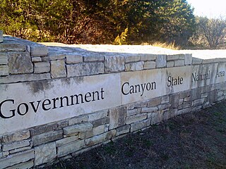
First opened to the public in October, 2005, Government Canyon State Natural Area (GCSNA) preserves 12,244 acres of rugged hills and canyons typical of the Texas Hill Country. It is designated a Natural Area, rather than a State Park, and therefore the primary focus is maintenance and protection of the property's natural state. Accordingly, access and recreational activities may be restricted if the Texas Parks & Wildlife Department (TPWD) deems such action necessary to protect the environment.

Daingerfield State Park is a 506.913-acre (2.05140 km2) state park in Morris County, Texas, southwest of Texarkana, including 80-acre (320,000 m2) Lake Daingerfield. The park opened in 1938 and is managed by the Texas Parks and Wildlife Department.

Lake Bob Sandlin State Park is a state park in Titus County, Texas managed by the Texas Parks and Wildlife Department. The park covers 639.8 acres of land on the northern shore Lake Bob Sandlin about 10 miles southwest of Mount Pleasant.

South Llano River State Park is a 2600 acre state park located along the South Llano River in Kimble County, Texas. The park opened to the public in 1990 and is managed by the Texas Parks and Wildlife Department.
Palo Pinto Mountains State Park is an undeveloped 4,000 plus acre state park in Palo Pinto and Stephens County, Texas near the City of Strawn. The park is located in the Western Cross Timbers Ecoregion. The park is administered by the Texas Parks and Wildlife Department which bought the property from private landowners in October 2011 with the assistance of The Nature Conservancy. The park is not yet open to the public.
Lake Brownwood State Park is a state park located on the shore of Lake Brownwood in Brown County, Texas, United States, and is administered by the Texas Parks and Wildlife Department. The 537.5 acre park was acquired by deed from the Brown County Water Improvement District No. 1 in 1933. The Civilian Conservation Corps (CCC) developed the park between 1934 and 1942. The park opened in 1938.
Lake Athens is a 1,799 acre reservoir located to the east of Athens, Texas in Henderson County.
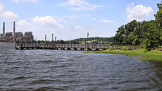
Martin Creek Lake State Park is a 286 acres (116 ha) developed recreational area in East Texas in the United States. The park is located southwest of Tatum on Martin Creek Lake in Rusk County and is managed by the Texas Parks and Wildlife Department. The Texas Utilities Generating Company deeded the park to the state in 1976, and it opened the same year.

Lake Arrowhead State Park is a state park located in Clay County, Texas, near Wichita Falls. The park is 524 acres (212 ha).

Lake Whitney State Park is a state park located in Hill County, Texas, near Whitney, Texas. The park is 775 acres (314 ha).

Lake Colorado City State Park is a 500-acre state park southwest of Colorado City in Mitchell County, Texas, United States and is administered by the Texas Parks and Wildlife Department (TPWD). Lake Colorado City State Park is located on Lake Colorado City, a reservoir on Morgan Creek, a tributary of the Colorado River. The park opened in 1972.