The Neches River begins in Van Zandt County west of Rhine Lake and flows for 416 miles (669 km) through the piney woods of east Texas, defining the boundaries of 14 counties on its way to its mouth on Sabine Lake near the Rainbow Bridge. Two major reservoirs, Lake Palestine and B. A. Steinhagen Reservoir are located on the Neches. The Angelina River is a major tributary with its confluence at the north of Lake B. A. Steinhagen. Tributaries to the south include Village Creek and Pine Island Bayou, draining much of the Big Thicket region, both joining the Neches a few miles north of Beaumont. Towns and cities located along the river including Tyler, Lufkin, and Silsbee, although significant portions of the Neches River are undeveloped and flow through protected natural lands. In contrast, the lower 40 miles of the river are a major shipping channel, highly industrialized, with a number of cities and towns concentrated in the area including Beaumont, Vidor, Port Neches, Nederland, Groves, and Port Arthur.

Augusta is a city in Woodruff County, Arkansas, United States, located on the east bank of the White River. The population was 1,998 as of the 2020 Census. The city is the county seat of Woodruff County.
The Cache River National Wildlife Refuge is a 68,993 acre (223 km2) (2014) wildlife refuge in the state of Arkansas managed by the United States Fish and Wildlife Service (FWS). The refuge is one of the Ramsar wetlands of international importance under the Ramsar Convention signed in 1971. It is one of the most important wintering area for ducks and the largest remaining tract of contiguous bottomland hardwood forest on the North American continent. In 2005, a possible sighting of the ivory-billed woodpecker, thought to be extinct, brought attention to the refuge.
The Felsenthal National Wildlife Refuge (NWR) is a 76,000 acre (307.56 km2) national wildlife refuge located in south-central Arkansas in Ashley, Bradley, and Union counties. Felsenthal NWR is one of three refuges forming an administrative complex, which also includes Pond Creek NWR to the northwest and Overflow NWR to the east.

The Bald Knob National Wildlife Refuge is a 15,022 acres (60.79 km2) (2014) wildlife refuge located in White County, Arkansas about two miles south of the town of Bald Knob. The refuge is managed by the United States Fish and Wildlife Service. The refuge features large numbers of migratory waterfowl and bald eagles during the winter months.

Big Lake National Wildlife Refuge is an 11,047-acre (45 km2) National Wildlife Refuge located in Mississippi County, Arkansas, managed by the United States Fish and Wildlife Service. It is situated 2 miles (3.2 km) east of Manila, Arkansas, and consists mostly of a shallow lake, swamp, and bottomland hardwood forests. The preservation of habitat for waterfowl in an intensely agricultural region is the primary purpose of the refuge. 6,400 acres (20 km2) of Big Lake was named a National Natural Landmark. 2,144 acres (8 km2) are designated as wilderness.
Pond Creek National Wildlife Refuge (NWR) is a 27,300 acre (110 km2) national wildlife refuge located in Sevier County, Arkansas. Pond Creek NWR is one of three refuges forming an administrative complex, which also includes Felsenthal NWR and Overflow NWR to the east.

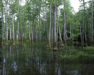
The Piney Woods is a temperate coniferous forest terrestrial ecoregion in the Southern United States covering 54,400 square miles (141,000 km2) of East Texas, southern Arkansas, western Louisiana, and southeastern Oklahoma. These coniferous forests are dominated by several species of pine as well as hardwoods including hickory and oak. Historically the most dense part of this forest region was the Big Thicket though the lumber industry dramatically reduced the forest concentration in this area and throughout the Piney Woods during the 19th and 20th centuries. The World Wide Fund for Nature considers the Piney Woods to be one of the critically endangered ecoregions of the United States. The United States Environmental Protection Agency (EPA) defines most of this ecoregion as the South Central Plains.

Marais des Cygnes National Wildlife Refuge (NWR) is located in Linn County, Kansas along the Marais des Cygnes River. The 7,500 acre (30 km2) Refuge was established in 1992 to protect one of the northwesternmost examples of bottomland hardwood forest in the United States as well as the largest contiguous tract of bottomland hardwood forest in Kansas.

The Deep Fork National Wildlife Refuge (DFNWR) is part of the United States system of National Wildlife Refuges, and is a critical resource for wildfowl that migrate along the Central Flyway in Spring and Fall. It is located in Eastern Oklahoma, near the city of Okmulgee. The preserve runs along both banks of the Deep Fork River for about 20 miles (32 km). According to TravelOK, DFNWR receives about 45,000 visitors every year.
The Yazoo National Wildlife Refuge is a 12,941 acre (52.4 km2) National Wildlife Refuge located in Washington County, Mississippi. Named after the Yazoo tribe, it was established to provide waterfowl and other migratory birds in the Mississippi Flyway with nesting, feeding, brooding, and resting habitat.

The Mingo National Wildlife Refuge is a 21,676-acre (87.7-km2) National Wildlife Refuge located in northwestern Stoddard and southeastern Wayne counties in Missouri. Its southwesternmost portion lies on the shores of Lake Wappapello. Named after the Mingo tribe, it was established to preserve bottomland hardwoods and provide waterfowl and other migratory birds in the Mississippi Flyway with nesting, feeding, brooding, and resting habitat.
The Cypress Creek National Wildlife Refuge is an American wildlife refuge. It is located in the Cache River watershed in southernmost Illinois, largely in Pulaski County, but with extensions into Union, Alexander, and Johnson counties. The refuge was established in 1990 under the authority of the Emergency Wetlands Resources Act of 1986. The refuge protects over 16,000 acres (65 km2) of the Cache River wetlands, and has a purchase boundary of 36,000 acres (146 km²) contiguous.
Bayou Cocodrie National Wildlife Refuge was established in 1992 to protect some of the last remaining, least-disturbed bottomland hardwood forest tracts in the Lower Mississippi Valley. These wooded wetlands, oxbow lakes, brakes, sloughs, and bayous, are inhabited seasonally by over 150 species of migratory birds, including forest-breeding birds, water birds, and waterfowl. The 15,155-acre (61.33 km2) refuge is located in Concordia Parish, Louisiana, 10 miles (16 km) southwest of Vidalia, Louisiana. It is named for the state-designated scenic river which runs through its center.

D'Arbonne National Wildlife Refuge is a National Wildlife Refuge of the United States located north of West Monroe, Louisiana. It is in Ouachita and Union Parishes on either side of Bayou D'Arbonne near its confluence with the Ouachita River. It lies on the western edge of the Mississippi River alluvial valley. It was established in 1975 to protect bottomland hardwoods and provide wintering habitat for migratory waterfowl. D'Arbonne is one of four refuges managed in the North Louisiana Refuges Complex.
Lake Ophelia National Wildlife Refuge was established in 1988 to protect the Mississippi/Red River floodplain ecosystem. The refuge is located in Avoyelles Parish, Louisiana, east central Louisiana. The refuge is named for its most prominent water body, the 350-acre (1.4 km2) Lake Ophelia that was at one time a channel of the nearby Red River of the South.
Bond Swamp National Wildlife Refuge, located 6 miles south of Macon, Georgia, United States, was established in 1989 to protect, maintain and enhance the forested wetland ecosystem of the Ocmulgee River floodplain. It opened to the public in 2000 and consists of 8,600 acres situated along the fall line separating the Piedmont and Coastal Plains. The acquisition boundary established in 1999 includes around 17,000 acres, though the Fish and Wildlife service has been unable to acquire much private land. The refuge has a diversity of vegetation communities, including mixed hardwood-pine, bottomland hardwoods, tupelo gum swamp forests, creeks, tributaries, beaver swamps and oxbow lakes. The refuge is rich in wildlife diversity including white-tailed deer, wood ducks, black bears, alligators, wild turkey, a nesting pair of bald eagles and excellent wintering habitat for waterfowl. Extensive bottomland hardwoods provide critical habitat for neotropical songbirds of concern, such as Swainson's warbler, wood thrush, prothonotary warbler and yellow-billed cuckoo. The combination of warm weather and wet areas at Bond Swamp provide ideal conditions for a variety of reptile and amphibian species.

Roanoke River National Wildlife Refuge was established in 1989 to protect and enhance wooded wetlands consisting of bottomland hardwoods and swamps with high waterfowl value along the Roanoke River. The extensive bottomland hardwood habitat of the Roanoke River National Wildlife Refuge is part of what the Nature Conservancy calls "one of the last great places."
Trinity River National Wildlife Refuge was established on January 4, 1994 with an initial purchase of 4,400 acres (18 km2). Since that time, the refuge has acquired additional acreage which now totals 30,000 acres (120 km2). The primary purpose of establishing this refuge is to protect a portion of the bottomland hardwood forest ecosystem along the Trinity River located in southeastern Texas. The refuge, which is a remnant of what was once a much larger natural area is a broad flat floodplain made up of numerous sloughs, oxbow lakes, artesian wells, and tributaries.
The Little River National Wildlife Refuge is a National Wildlife Refuge of the United States located in Oklahoma. It covers 15,000 acres (61 km2) of forests and wetlands.

