Ogburn, Texas

Last updated

Ogburn, Texas
USA Texas location map.svg
Red pog.svg
Ogburn
Usa edcp location map.svg
Red pog.svg
Ogburn
Coordinates: 32°50′24″N95°13′21″W / 32.84000°N 95.22250°W / 32.84000; -95.22250
Country United States
State Texas
County Wood
Elevation
[1]
600 ft (200 m)
Time zone UTC-6 (Central (CST))
  Summer (DST) UTC-5 (CDT)
Area code(s) 430, 903
GNIS feature ID1378786 [1]

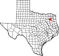
Ogburn is an unincorporated community in Wood County, located in the U.S. state of Texas. [1] According to the Handbook of Texas,[ citation needed ] Ogburn had a population of 10 in 2000.

Contents

Geography

Ogburn is located just off Farm to Market Road 2088, 15 mi (24 km) east of Quitman in eastern Wood County. [2]

Education

Ogburn's school closed sometime in the 1940s. [2] Today, the community is served by the Winnsboro Independent School District.

Related Research Articles

<span class="mw-page-title-main">Wood County, Texas</span> County in Texas, United States

Wood County is a county located in the U.S. state of Texas. As of the 2020 census, its population was 44,843. Its county seat is Quitman. The county was named for George T. Wood, governor of Texas from 1847 to 1849.

<span class="mw-page-title-main">Smith County, Texas</span> County in Texas, United States

Smith County is a county in the U.S. state of Texas. As of the 2020 census, its population was 233,479. Its county seat is Tyler. Smith County is named for James Smith, a general during the Texas Revolution.

<span class="mw-page-title-main">Real County, Texas</span> County in Texas, United States

Real County is a county located on the Edwards Plateau in the U.S. state of Texas. As of the 2020 census, its population was 2,758. The county seat is Leakey. The county is named for Julius Real (1860–1944), a former member of the Texas State Senate. The Alto Frio Baptist Encampment is located in an isolated area of Real County southeast of Leakey.

<span class="mw-page-title-main">Hillsboro, Texas</span> City in Texas, United States

Hillsboro is a city in and the county seat of Hill County, Texas, United States. It is located between Dallas, Fort Worth and Waco, directly on Interstate 35 in North Central Texas. Hillsboro draws trade from throughout the county, and from Interstate 35 travelers between Dallas, Fort Worth, and Waco.

<span class="mw-page-title-main">Mineola, Texas</span> City in Texas, United States

Mineola is a city in the U.S. state of Texas in Wood County. It lies 26 miles north of Tyler. Its population was 4,823 at the 2020 census.

<span class="mw-page-title-main">Quitman, Texas</span> City in Texas, United States

Quitman is a city and the county seat of Wood County, Texas, United States. Its population was 1,942 at the 2020 census. The city was named for John A. Quitman, a veteran of the Mexican–American War, and once governor of Mississippi.

<span class="mw-page-title-main">Katy, Texas</span> City in Texas, United States

Katy is a city in the U.S. state of Texas. It is in the Greater Katy area, itself forming the western part of the Greater Houston metropolitan area. Homes and businesses may have Katy postal addresses without being in the City of Katy. The city of Katy is approximately centered at the tripoint of Harris, Fort Bend, and Waller counties. Katy had a population of 21,894 at the 2020 U.S. census, up from 14,102 in 2010.

<span class="mw-page-title-main">Karnack, Texas</span> Unincorporated community in Texas, US

Karnack is a rural unincorporated community in northeastern Harrison County near Caddo Lake in the eastern region of the U.S. state of Texas.

Clear Lake is a populated place located in Collin County, Texas, United States. According to the Handbook of Texas, the community had a population of 50 in 1990. It is located within the Dallas-Fort Worth Metroplex.

<span class="mw-page-title-main">Northeast Texas</span> Region in Texas, United States

Northeast Texas is a cultural and geographic region in the northeast corner of the U.S. state of Texas. Geographically centered on two metropolitan areas strung along Interstate 20—Tyler in the west and Longview/Marshall to the east, the areas of Greenville, Mount Pleasant, Sulphur Springs, Paris, and Texarkana in the north primarily along Interstate 30, and Jacksonville and Palestine to the south are also major cities within the region. Most of Northeast Texas is included in the interstate region of the Ark-La-Tex.

<span class="mw-page-title-main">Plato, Missouri</span> Village in Missouri, United States

Plato is an incorporated village in northwestern Texas County, Missouri, United States. It is located approximately 20 miles northwest of Houston and 10 miles south of Fort Leonard Wood on Route 32. The population was 82 at the 2020 census.

<span class="mw-page-title-main">Central Texas College</span> Community college in Killeen, Texas, U.S.

Central Texas College (CTC) is a public community college in Killeen, Texas. Founded in 1965, it has branch campuses in Europe and on military installations across the U.S.

Ferris Independent School District is a public school district based in Ferris, Texas (US).

Crow is an unincorporated community in Wood County, Texas, United States. According to the Handbook of Texas, Crow had a population of 25 in 2000.

<span class="mw-page-title-main">Maydelle, Texas</span> Unincorporated community in Texas, United States

Maydelle is a small unincorporated community in Cherokee County, Texas, United States. According to the Handbook of Texas, the community had a population of 250 in 2000. It is located within the Tyler-Jacksonville combined statistical area.

Chateau Woods is an unincorporated community in southern Montgomery County, Texas, United States, that was formerly an incorporated municipality. It is located east of Interstate 45, approximately 10 miles (16 km) south of Conroe and 27 miles (43 km) north of Houston.

<span class="mw-page-title-main">Cave Creek School (Gillespie County, Texas)</span> United States historic place

Cave Creek School is located at 470 Cave Creek Road, in Gillespie County, in the U.S. state of Texas. Built in 1881, it was consolidated with Fredericksburg Independent School District in 1950. The building is now used as a community center. It was added to the National Register of Historic Places in Texas on December 29, 2004.

Saint Annie was an unincorporated community in southwest Pulaski County, Missouri, United States. The community was about a mile south of Cookville, but the post office moved depending on where the postmaster lived. The last active post office was located on Webster Drive just west of the Laclede-Texas county line approximately five miles north of Lynchburg. The community of Winnipeg is about 3 1/2 miles to the northwest.

<span class="mw-page-title-main">Williams Creek School (Gillespie County, Texas)</span> United States historic place

Williams Creek School is located at 5501 South Ranch to Market Road 1623 in Gillespie County, in the U.S. state of Texas. Although now consolidated with the community of Stonewall, the school is actually located south of there in the ghost town of Albert. It was established in 1891 as the Albert School, and was originally a log cabin on Williams Creek. Six years later, it was moved farther from the creek onto a larger piece of land. A new building was constructed of native limestone.

Ora is a ghost town in Angelina County, in the U.S. state of Texas. It is located within the Lufkin, Texas micropolitan area.

References

  1. 1 2 3 U.S. Geological Survey Geographic Names Information System: Ogburn, Texas
  2. 1 2 Jenkins, Rachel. "Ogburn, TX". tshaonline.org. Retrieved June 8, 2023.