Lake Lyndon B. Johnson is a reservoir on the Colorado River in the Texas Hill Country about 45 miles northwest of Austin. The reservoir was formed in 1950 by the construction of Granite Shoals Dam by the Lower Colorado River Authority (LCRA). The Colorado River and the Llano River meet in the northern portion of the lake at Kingsland.

Sam Houston Johnson was an American businessman. He was the younger brother of President Lyndon B. Johnson.

The Lyndon Baines Johnson Library and Museum, also known as the LBJ Presidential Library, is the presidential library and museum of Lyndon Baines Johnson, the 36th president of the United States (1963–1969). It is located on the grounds of the University of Texas at Austin, and is one of 13 presidential libraries administered by the National Archives and Records Administration. The LBJ Library houses 45 million pages of historical documents, including the papers of President Johnson and those of his close associates and others.

Butte Valley National Grassland is a 18,425-acre (7,456 ha) United States National Grassland located in northern California. Administered by the United States Forest Service, Klamath National Forest, it is located in northern Siskiyou County, near the Oregon border, between the communities of Dorris and Macdoel along U.S. Highway 97. It was dedicated in July 1991 as the nation's 20th National Grassland. It is administered as part of the Klamath National Forest, and is the sole National Grassland in California and in Region 5 of the Forest Service. Administrative offices are located in Macdoel, California.

Custer National Forest is located primarily in the south central part of the U.S. state of Montana but also has separate sections in northwestern South Dakota. With a total area of 1,188,130 acres (4,808 km2), the forest comprises over 10 separate sections. While in the westernmost sections, Custer National Forest is a part of the Greater Yellowstone Ecosystem, the easternmost sections are a combination of forest "islands" and grasslands. A portion of the forest is also part of the Absaroka-Beartooth Wilderness and constitutes over a third of the wilderness land. South of Red Lodge, Montana, the Beartooth Highway passes through the forest en route to Yellowstone National Park.

Lyndon B. Johnson National Historical Park is a United States National Historical Park in central Texas about 50 miles (80 km) west of Austin in the Texas Hill Country. The park protects the birthplace, home, ranch, and grave of Lyndon B. Johnson, 36th president of the United States. During Johnson's administration, the LBJ Ranch was known as the Texas White House because the President spent approximately 20% of his time in office there.

The Cibola National Forest is a 1,633,783 acre United States National Forest in New Mexico, US. The name Cibola is thought to be the original Zuni Indian name for their pueblos or tribal lands. The name was later interpreted by the Spanish to mean "buffalo". The forest is disjointed with lands spread across central and northern New Mexico, west Texas and Oklahoma. The Cibola National Forest is divided into four Ranger Districts: the Sandia, Mountainair, Mt. Taylor, and Magdalena. The Forest includes the San Mateo, Magdalena, Datil, Bear, Gallina, Manzano, Sandia, Mt. Taylor, and Zuni Mountains of west-central New Mexico. The Forest also manages four National Grasslands that stretch from northeastern New Mexico eastward into the Texas Panhandle and western Oklahoma. The Cibola National Forest and Grassland is administered by Region 3 of the United States Forest Service from offices in Albuquerque, New Mexico. Elevation ranges from 5,000 ft to 11,301 ft. The descending order of Cibola National Forest acres by county are: Socorro, Cibola, McKinley, Catron, Torrance, Bernalillo, Sandoval County, New Mexico, Lincoln, Sierra, and Valencia counties in New Mexico. The Cibola National Forest currently has 137,701 acres designated as Wilderness. In addition to these acres, it has 246,000 acres classified as Inventoried Roadless Areas pursuant to the Roadless Area Conservation Rule.

Buffalo Gap National Grassland is a National Grassland located primarily in southwestern South Dakota, United States. It is also the second largest National Grassland, after Little Missouri National Grassland in North Dakota. Characteristics of the grasslands include mixed prairie and chalky badlands. The grassland is managed by the U.S. Forest Service and is a division of Nebraska National Forest. In descending order of land area it is located in parts of Fall River, Pennington, Jackson, and Custer counties.

Caddo National Grassland is a national grassland in the southern Great Plains, consisting of two separate sections located in northeastern and southeastern Fannin County, Texas, United States. It is a 17,873-acre (7,233 ha) protected area that was purchased in the 1930s. The goal of the park when purchased was to restore the eroded soil. Two developed recreation areas are around Lake Davy Crockett, which is 388 acres (157 ha) in size. The grassland is divided into two units: Bois d'Arc Creek and Ladonia.
Rita Blanca National Grassland is a National Grassland on the Great Plains near the community of Texline in northwest Dallam County, Texas, in the Texas Panhandle, and in southern Cimarron County, Oklahoma, in the western Oklahoma Panhandle. The principal city in the area is Dalhart, Texas, which houses the XIT Museum.

Sheyenne National Grassland is a National Grassland located in southeastern North Dakota in the United States, comprising 70,446 acres (28,508 ha) of public land amid 64,769 acres (26,211 ha) of privately owned land in a region of sandy soils in the vicinity of the Sheyenne River in Ransom and Richland Counties. It is the only National Grassland in the tallgrass prairie region of the U.S. The grassland provides habitat for the largest population of greater prairie chickens in North Dakota, as well as the Dakota skipper butterfly, the western prairie fringed orchid, and numerous ferns, as well as grazing land for approximately 83 cattle ranchers.

The Lyndon B. Johnson School of Public Affairs is a graduate school at the University of Texas at Austin that was founded in 1970. The school offers training in public policy analysis and administration in government and public affairs-related areas of the private and nonprofit sectors. Degree programs include a Master of Public Affairs (MPAff), a mid-career MPAff sequence, 16 MPAff dual degree programs, a Master of Global Policy Studies (MGPS), eight MGPS dual degree programs, an Executive Master of Public Leadership, and a Ph.D. in public policy.

Lyndon Baines Johnson Memorial Grove on the Potomac is located on Lady Bird Johnson Park, in Washington, D.C. The presidential memorial honors the 36th President of the United States, Lyndon B. Johnson.

Lincoln National Forest is a unit of the U.S. Forest Service located in southern New Mexico. The Lincoln National Forest covers an extensive 1.1 million acres in southeastern New Mexico. Established by Presidential Proclamation in 1902 as the Lincoln Forest Reserve, the 1,103,897 acres (4,467.31 km2) forest begins near the Texas border and contains lands in parts of Chaves, Eddy, Lincoln, and Otero counties. The Lincoln National Forest is home to three major mountain ranges: Sacramento, Guadalupe and Capitan. The three Ranger Districts within the forest contain all or part of a total of four mountain ranges, and include a variety of different environmental areas, from desert to heavily forested mountains and sub-alpine grasslands. Clean air, water, and soil are necessary elements that the National Forests contribute to the environment. Established to balance conservation, resource management, and recreation, the lands of the Lincoln National Forest include important local timber resources, protected wilderness areas, and popular recreation and winter sports areas. The forest headquarters is located in Alamogordo, N.M. with local offices in Carlsbad, Cloudcroft, and Ruidoso.

The Sam Houston National Forest, one of four National Forests in Texas, is located 50 miles north of Houston. The forest is administered together with the other three United States National Forests and two National Grasslands located entirely in Texas, from common offices in Lufkin, Texas. The units include Angelina, Davy Crockett, Sabine, and Sam Houston National Forests, plus Caddo National Grassland and Lyndon B. Johnson National Grassland. There are local ranger district offices located in New Waverly. It is located in portions of three Texas counties including Montgomery, San Jacinto, and Walker.
Sabine National Forest is located in East Texas near the Texas-Louisiana border. The forest is administered together with the other three United States National Forests and two National Grasslands located entirely in Texas, from common offices in Lufkin, Texas. There are local ranger district offices located in Hemphill.

Davy Crockett National Forest in Kennard, Texas is off U.S. Highway 69 lying west of Lufkin, Texas and east of Crockett. It is administered by the United States Department of Agriculture Forest Service local headquarters in Lufkin. There are local ranger district offices located in Ratcliff.

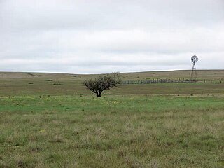
Rucker Pond is a reservoir within the LBJ National Grasslands. The pond is located in North Texas in Wise County near Decatur, and is operated by the United States Forest Service. It is off County Road 2650. Among Rucker Pond's fish species are largemouth bass.

The Black Kettle National Grassland, in Roger Mills County, Oklahoma, and Hemphill County, Texas, contains 31,286 acres (12,661 ha) of which 30,710 acres (12,430 ha) are in Oklahoma.