The United States Forest Service (USFS) is an agency within the U.S. Department of Agriculture that administers the nation's 154 national forests and 20 national grasslands covering 193 million acres (780,000 km2) of land. The major divisions of the agency are the Chief's Office, National Forest System, State and Private Forestry, Business Operations, as well as Research and Development. The agency manages about 25% of federal lands and is the sole major national land management agency not part of the U.S. Department of the Interior.
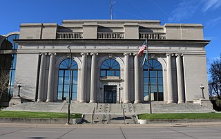
Pennington County is a county in the U.S. state of South Dakota. As of the 2020 census, the population was 109,222, making it the second most populous county in South Dakota. Its county seat is Rapid City. The county was created in 1875, and was organized in 1877. It is named for John L. Pennington, fifth Governor of Dakota Territory, who held office in 1875 when the county was formed.
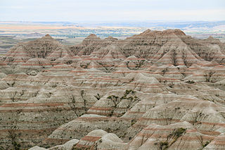
Badlands National Park is an American national park in southwestern South Dakota. The park protects 242,756 acres of sharply eroded buttes and pinnacles, along with the largest undisturbed mixed grass prairie in the United States. The National Park Service manages the park, with the South Unit being co-managed with the Oglala Lakota tribe.

A national grassland is an area of protected and managed federal lands in the United States authorized by Title III of the Bankhead–Jones Farm Tenant Act of 1937 and managed by the United States Forest Service. For administrative purposes, they are essentially identical to national forests, except that grasslands are areas primarily consisting of prairie. Like national forests, national grasslands may be open for hunting, grazing, mineral extraction, recreation and other uses. Various national grasslands are typically administered in conjunction with nearby national forests.

Theodore Roosevelt National Park is an American national park of the badlands in western North Dakota comprising three geographically separated areas. Honoring U.S. President Theodore Roosevelt, it is the only American national park named directly after a single person.

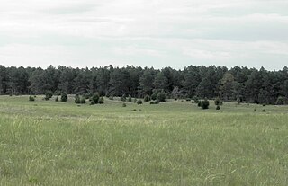
The Oglala National Grassland is a United States National Grassland in the northwest corner of Nebraska. It is in northern Sioux and northwestern Dawes counties, on the borders with South Dakota and Wyoming. It is 94,520 acres (38,250 ha) in size and is one of the small handful of National Grasslands administered by the US Department of Agriculture's Forest Service. It is managed by the U.S. Forest Service together with the Nebraska and Samuel R. McKelvie National Forests and the Buffalo Gap and Fort Pierre National Grasslands from common offices in Chadron, Nebraska.

Charmaine White Face, or Zumila Wobaga, is an Oglala Tetuwan from the Oceti Sakowin in North America.

The Midewin National Tallgrass Prairie (MNTP) is a tallgrass prairie reserve and is preserved as United States National Grassland operated by the United States Forest Service. The first national tallgrass prairie ever designated in the U.S. and the largest conservation site in the Chicago Wilderness region, it is located on the site of the former Joliet Army Ammunition Plant between the towns of Elwood, Manhattan and Wilmington in northeastern Illinois. Since 2015, it has hosted a conservation herd of American bison to study their interaction with prairie restoration and conservation.

Custer National Forest is located primarily in the south central part of the U.S. state of Montana but also has separate sections in northwestern South Dakota. With a total area of 1,188,130 acres (4,808 km2), the forest comprises over 10 separate sections. While in the westernmost sections, Custer National Forest is a part of the Greater Yellowstone Ecosystem, the easternmost sections are a combination of forest "islands" and grasslands. A portion of the forest is also part of the Absaroka-Beartooth Wilderness and constitutes over a third of the wilderness land. South of Red Lodge, Montana, the Beartooth Highway passes through the forest en route to Yellowstone National Park.

The Cibola National Forest is a 1,633,783 acre United States National Forest in New Mexico, US. The name Cibola is thought to be the original Zuni Indian name for their pueblos or tribal lands. The name was later interpreted by the Spanish to mean "buffalo." The forest is disjointed with lands spread across central and northern New Mexico, west Texas and Oklahoma. The Cibola National Forest is divided into four Ranger Districts: the Sandia, Mountainair, Mt. Taylor, and Magdalena. The Forest includes the San Mateo, Magdalena, Datil, Bear, Gallina, Manzano, Sandia, Mt. Taylor, and Zuni Mountains of west-central New Mexico. The Forest also manages four National Grasslands that stretch from northeastern New Mexico eastward into the Texas Panhandle and western Oklahoma. The Cibola National Forest and Grassland is administered by Region 3 of the United States Forest Service from offices in Albuquerque, New Mexico. Elevation ranges from 5,000 ft to 11,301 ft. The descending order of Cibola National Forest acres by county are: Socorro, Cibola, McKinley, Catron, Torrance, Bernalillo, Sandoval County, New Mexico, Lincoln, Sierra, and Valencia counties in New Mexico. The Cibola National Forest currently has 137,701 acres designated as Wilderness. In addition to these acres, it has 246,000 acres classified as Inventoried Roadless Areas pursuant to the Roadless Area Conservation Rule.

The Nebraska National Forest is a United States National Forest located within the U.S. state of Nebraska. The total area of the national forest is 141,864 acres, or 222 sq miles (574 km2). The forest is managed by the U.S. Forest Service's Nebraska Forests and Grasslands Supervisor's Office in Chadron, Nebraska. The national forest includes two ranger districts, the Bessey Ranger District and the Pine Ridge Ranger District. In descending order of land, the forest lies in parts of Thomas, Dawes, Blaine, and Sioux counties.
The Samuel R. McKelvie National Forest is a United States National Forest in the north-central Sandhills region of the U.S. state of Nebraska. The area of the national forest is 116,079 acres (181.373 sq mi). The forest is managed as part of the U.S. Forest Service's Nebraska National Forests and Grasslands, from ranger district offices in Halsey, Nebraska. The national forest is entirely within Cherry County, Nebraska.

Black Hills National Forest is located in southwestern South Dakota and northeastern Wyoming, United States. The forest has an area of over 1.25 million acres (5,066 km2) and is managed by the Forest Service. Forest headquarters are located in Custer, South Dakota. There are local ranger district offices in Custer, Rapid City, and Spearfish in South Dakota, and in Sundance, Wyoming.

Grand River National Grassland is a National Grassland in northwestern South Dakota, United States. It is named for the Grand River. The North and South forks of the rivers meet in the grassland. It has a land area of 154,783 acres (62,638 ha). In descending order of acreage it lies in parts of Perkins, Corson, and Ziebach counties. The portion in Corson County also lies within the Standing Rock Indian Reservation. The portion in Ziebach County also lies within the Cheyenne River Indian Reservation.

Fort Pierre National Grassland is a United States National Grassland in central South Dakota, south of the capital city Pierre and its neighbor Fort Pierre. The national grassland is primarily a mixed-grass prairie and has a land area of 115,890 acres (46,900 ha). In descending order of area it lies in parts of Lyman, Stanley, and Jones counties. Part of the movie Dances with Wolves was filmed there. It is managed by the U.S. Forest Service together with the Nebraska and Samuel R. McKelvie National Forests and the Buffalo Gap and Oglala National Grasslands from common offices in Chadron, Nebraska. There is a local ranger district office located in Pierre.

Little Missouri National Grassland is a National Grassland located in western North Dakota, United States. At 1,028,051 acres (416,037 ha), it is the largest grassland in the country. Enclaved within its borders is Theodore Roosevelt National Park, which is managed by the National Park Service. The Little Missouri National Grassland was once a part of the Custer National Forest, but is now a part of the Dakota Prairie Grasslands, a National Forest unit consisting entirely of National Grasslands. A predominant feature of the grassland is colorful and beautiful badlands, a rugged terrain extensively eroded by wind and water. It is a mixed grass prairie, meaning it has both long and short grass.

Lyndon B. Johnson (LBJ) National Grassland is a national grassland located in the Great Plains of the northern part of the U.S. state of Texas near Decatur, and within an hour's drive from Fort Worth. It is primarily used for recreation, such as hiking, camping, horseback riding, fishing, and hunting. It is also used as grazing land for cattle and other livestock.

Sheyenne National Grassland is a National Grassland located in southeastern North Dakota in the United States, comprising 70,446 acres (28,508 ha) of public land amid 64,769 acres (26,211 ha) of privately owned land in a region of sandy soils in the vicinity of the Sheyenne River in Ransom and Richland Counties. It is the only National Grassland in the tallgrass prairie region of the U.S. The grassland provides habitat for the largest population of greater prairie chickens in North Dakota, as well as the Dakota skipper butterfly, the western prairie fringed orchid, and numerous ferns, as well as grazing land for approximately 83 cattle ranchers.

Lincoln National Forest is a unit of the U.S. Forest Service located in southern New Mexico. The Lincoln National Forest covers an extensive 1.1 million acres in southeastern New Mexico. Established by Presidential Proclamation in 1902 as the Lincoln Forest Reserve, the 1,103,897 acres (4,467.31 km2) forest begins near the Texas border and contains lands in parts of Chaves, Eddy, Lincoln, and Otero counties. The Lincoln National Forest is home to three major mountain ranges: Sacramento, Guadalupe and Capitan. The three Ranger Districts within the forest contain all or part of a total of four mountain ranges, and include a variety of different environmental areas, from desert to heavily forested mountains and sub-alpine grasslands. Clean air, water, and soil are necessary elements that the National Forests contribute to the environment. Established to balance conservation, resource management, and recreation, the lands of the Lincoln National Forest include important local timber resources, protected wilderness areas, and popular recreation and winter sports areas. The forest headquarters is located in Alamogordo, N.M. with local offices in Carlsbad, Cloudcroft, and Ruidoso.
Eriogonum visheri is a species of wild buckwheat known by the common names Dakota wild buckwheat and Visher's buckwheat. It is native to the Great Plains in the United States, where it is known from North Dakota, South Dakota, and Montana.