Huron Wetland Management District is located in the U.S. state of South Dakota and includes 17,518 acres (70.89 km2). The refuge borders the Missouri River on the east and is managed by the U.S. Fish and Wildlife Service. Huron WMD covers eight counties in east-central South Dakota. The topography of this area ranges from flat, gently rolling drift prairie to the Missouri Coteau hills in the western end of the district. The district lies in the midst of the Prairie Pothole Region.
Lake Andes Wetland Management District is located in the U.S. state of South Dakota and includes 82,731 acres (334 km2). The refuge is managed by the U.S. Fish and Wildlife Service. Of the land area in the district, the U.S. Government owns only 19,177 acres (77.6 km2), while the remaining area is managed as an easement to help protect Waterfowl Production Areas from future development. The district oversees numerous wetland zones in an effort to ensure species protection. During Spring and Fall migration periods, tens of thousands of migratory birds can be found here, representing over 100 different species. The district is a part of the Lake Andes National Wildlife Refuge Complex. Bald eagles, northern pintail, mallards, snow geese, great grey owl, American kestrel, red-tailed hawk and prairie chicken are some of the more impressive bird species that can be found in the district.
The Arrowwood National Wildlife Refuge Complex consists of numerous National Wildlife Refuges and Wetland Management Districts in the U.S. state of North Dakota. Altogether, twelve separate areas are in the complex, with the Chase Lake Prairie Project being the largest at 5.5 million acres (22,000 km2).

Chase Lake Wetland Management District is located in the U.S. state of North Dakota around Chase Lake. The district is located in what is known as the Prairie Pothole Region of lakes and ponds, which were left behind by the retreat of glaciers at the end of the last ice age. It was established in 1993.
The Valley City Wetland Management District is located in the U.S. state of North Dakota and consists of 76,000 acres (307 km2). The wetland district is a substation of the Arrowwood National Wildlife Refuge Complex, overseen by the U.S. Fish and Wildlife Service. 82 waterfowl production areas and four separate national wildlife refuges which are privately owned are in turn managed by the wetland district as easement refuges. The wetland district is in portions of 5 counties in the Prairie Pothole Region that was created by the retreat of glaciers 12,000 years ago, during the last glacial maximum. One third of the protected lands are wetlands with the balance consisting of prairie.
Audubon Wetland Management District is located in the U.S. state of North Dakota and consists of 123 Waterfowl Production Areas (WPAs), 8 National Wildlife Refuges (NWRs), and numerous wetland and grassland easements and over 100 separate wetland areas set aside to preserve habitat for bird, plant and mammal species. These lands contain valuable wetland and grassland habitat for waterfowl and other migratory birds, and many other species of wildlife. Scattered throughout west central and southwestern North Dakota in McLean, Ward, and Sheridan Counties, the district is managed by the U.S. Fish and Wildlife Service and from Audubon National Wildlife Refuge. Hundreds of lakes and marshlands in this region provide critical habitat for migratory and nesting bird species.
The Lostwood Wetland Management District is located in the U.S. state of North Dakota and extends from the Canada–United States border to the neighboring state of Montana. The district consists almost exclusively of privately owned property, and landowners work cooperatively with the U.S. Fish and Wildlife Service to manage the land to maximize natural and agricultural needs. Hundreds of small bodies of water, wetlands and uplands are set aside to increase bird productivity and provide habitat for native animals and plants. The district comprises various areas spread throughout northwestern North Dakota which include waterfowl production areas, wetland easements, grassland easements, and easement refuges. The properties are located in Mountrail and part of Ward County, North Dakota.

The Michigan Wetland Management District consists of a 14-county area and includes three waterfowl production areas (WPAs): the 160-acre (0.65 km2) Schlee WPA and the 138-acre (0.56 km2) Mahan WPA in Jackson County and the 77-acre (310,000 m2) Kinney WPA in Van Buren County. The Michigan Department of Natural Resources, Wildlife Division, oversees day-to-day management of these three areas through a partnership with the U.S. Fish and Wildlife Service.

Straddling the headwaters of the Minnesota River in west-central Minnesota, Big Stone National Wildlife Refuge is within the heart of the tallgrass prairie's historic range. Today, less than one-percent of tallgrass prairie remains.

Waubay National Wildlife Refuge is a National Wildlife Refuge in South Dakota. "Waubay" means "a place where numbers of birds make their nests" in the Dakota language. The Refuge encompasses 4,650 acres (18.8 km2) of wetlands, native tallgrass prairie, and bur oak forest that provide a wide variety of nesting habitat for more than 100 species of waterfowl, song birds, and upland game birds as well as 140 additional bird species during migrations. Mammals include species from the ever-present white-tailed deer to the more elusive coyote and the diminutive pygmy shrew. The central location of Waubay National Wildlife Refuge in North America gives visitors the chance to see a mix of eastern, western, northern, and southern species.
Maple River National Wildlife Refuge is a National Wildlife Refuge in North Dakota. It is managed under Kulm Wetland Management District.
Detroit Lakes Wetland Management District is located in northwest Minnesota and includes the counties of Becker, Clay, Mahnomen, Norman, and Polk - an area of approximately 6,000 square miles (16,000 km2). The district is divided into three general landscape areas, roughly equal in size. From west to east, these are: the Red River Valley floodplain, the glacial moraine/prairie pothole region, and the hardwood/coniferous forest. The district currently manages over 42,000 acres (170 km2) of public land in 165 waterfowl production areas (WPAs). Additionally, district staff are responsible for more than 300 wetland and upland easements on private property, totaling more than 11,000 acres (45 km2).
The Minnesota Valley Wetland Management District is a fourteen-county district located in east central Minnesota, United States. It includes portions of the Minnesota, Cannon, and Mississippi River watersheds. The United States Fish and Wildlife Service works to protect the area's natural landscape through private lands habitat restorations, acquisition of waterfowl production areas (WPAs), and management of FmHA conservation easements. Since 1990, the Service has acquired 4,255 acres (17.22 km2) of WPAs and approximately 1,898 easement acres (7.68 km2). Private land restoration projects total 7,011 acres (28.37 km2) of wetland in 1,227 basins and 4,849 acres (19.62 km2) of native prairie on 223 sites.
The Morris Wetland Management District includes 244 waterfowl production areas, encompassing over 50,000 acres (200 km2) scattered throughout an eight-county area. Like other wetland management districts in the prairie states, the goal of the Morris District is to restore and protect sufficient wetland and grassland habitat to meet the needs of prairie wildlife, particularly breeding waterfowl, as well as provide places for public recreation.

The Windom Wetland Management District acquires and manages Waterfowl Production Areas, enforces wetland easements, and provides conservation assistance to landowners in 12 southwestern Minnesota counties. The landscape is dominated by intense, row-crop agriculture, which has led to the drainage of most wetlands and widespread water quality problems. Deteriorating drainage tile systems and the abundance of historic wetland basins provide unlimited opportunities for wetland restorations.
Devils Lake Wetland Management District is located in the heart of the Prairie Pothole Region of the United States. The District was established in 1962 to purchase and protect wetland habitat for migratory waterfowl and other wildlife in northeastern North Dakota. One of the primary objectives of Devils Lake Wetland Management District is to provide wetland and grassland habitat for waterfowl in the spring and summer for nesting and feeding. The other primary objective is to provide migration habitat for waterfowl in the spring and fall.

Located in south-central North Dakota, Kulm Wetland Management District was established in July 1971. Located in the Prairie Pothole Region of North America, Kulm Wetland Management District provides breeding, nesting, and brood rearing areas for many species of waterfowl and other migratory birds. The District currently manages 201 waterfowl production areas that total 45,683 acres (184.87 km2), 3 national wildlife refuges that are easement refuges, and 120,000 acres (490 km2) of wetland and grassland easements. The District's headquarters is in Kulm, North Dakota.

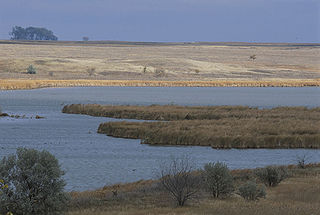
Long Lake Wetland Management District encompasses three counties in south-central North Dakota, an area famed for its wealth of waterfowl-producing potholes and native prairie grasslands. Headquarters for the Wetland Management District is located in the Long Lake National Wildlife Refuge office near Moffit, North Dakota, which is about 35 miles southeast of Bismarck. Topographical landforms of the area include Missouri Coteau and Missouri River Slope. Precipitation averages just under 16 inches per year. Approximately 68 percent of the land in the three county area remains virgin sod - native mixed-grass prairie. The dominant land use is cattle grazing. The Coteau wetlands found in the northeastern portion of the Wetland Management District are classic prairie potholes of various sizes and types that are prime duck production habitat. These areas, when wet, are very productive. Soils in this area are generally deep and quite productive. Due to the rolling nature of the landscape on the Coteau, a lot of the land is also characterized as highly erodible. Conversely, many of the wetlands on Missouri River Slope portion of the Wetland Management District are large semi-permanent and permanent alkali wetlands. There are 21 wetland sites on the Missouri River Slope that have a history of periodic avian botulism outbreaks. These areas occasionally present localized problems for significant numbers of migratory birds. Soils on the Missouri River Slope are characteristically shallow with high proportions of sand and gravel. Much of the land is highly erodible. Since 1985, substantial land acreage in the three county area that was once farmed has been retired to Conservation Reserve Program grasslands. The program has assisted in restoring waterfowl populations for many species in the Wetland Management District which exceed the highest level ever recorded since surveys began.
The St. Croix Wetland Management District in west-central Wisconsin, United States, encompasses a diversity of habitats lying along the eastern edge of the tallgrass prairie. Within the eight-county district, one can travel north through the high river bluffs of Pepin County, to the prairie potholes of St. Croix County, and then to the pine barrens of Burnett County.

The South Dakota Department of Game, Fish, and Parks (GFP) is the U.S. State of South Dakota's state agency charged with the management of the state's public recreational and outdoor resources. The GFP manages the 13 state parks and 43 state recreation areas within the state parks system, totaling over 96,000 acres of public lands. The agency manages the hunting of game and the state's fisheries, manages several wildlife management areas and game production areas to restore or establish habitat for a variety of species. The agency conducts public outdoor education programs, typically focusing on hunting and boating safety. The department issues hunting and fishing licenses along with issuance of boat registrations. The agency is also charged with enforcement of fish and game laws, including invasive species regulations. The agency is headquartered in Pierre, South Dakota.
 Lytta nuttalli (Nutall's blister beetle) on milkvetch at Waterfowl Production Area in Waubay Wetland Management District
 A spider waits on a purple coneflower for an unsuspecting victim at Lake Emma WPA
 A regal fritillary (Speyeria idalia) gets a meal from a purple coneflower ( Echinacea angustifolia ) at Lake Emma WPA in Waubay Wetland Management
 A pink wild onion ( Allium stellatum ) — blooms in the tallgrass prairie of Waubay Wetland Management District


