
Day County is a county in the U.S. state of South Dakota. As of the 2020 census, the population was 5,449. Its county seat is Webster. The county is named for Merritt H. Day, pioneer and 1879 Dakota Territory legislator.
Lacreek National Wildlife Refuge is a National Wildlife Refuge of the United States located in South Dakota. It covers 16,570 acres (67 km2) and is managed by the United States Fish and Wildlife Service.
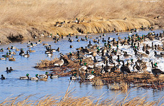
Sand Lake National Wildlife Refuge is located in the northeastern part of the U.S. state of South Dakota and is administered by the U.S. Fish and Wildlife Service. Created in 1935, it is a wetland of international importance and a Globally Important Bird Area. Over 260 bird species are found in the refuge, including many migratory bird species and the world's largest breeding colony of Franklin's gulls.

Chase Lake National Wildlife Refuge is located in the U.S. state of North Dakota around Chase Lake. The majority of the land area of the refuge has been designated as wilderness and is known as the Chase Lake Wilderness. The refuge is one of the oldest in the U.S., having been set aside in 1908. The refuge is home to one of the largest nesting colonies of white pelicans in the U.S.
The Sibley Lake National Wildlife Refuge is located in the U.S. state of North Dakota and consists of 1,077 acres (4.35 km2). Sibley Lake is a privately owned easement refuge, managed with by the U.S. Fish and Wildlife Service. The refuge was established to protect habitat for migratory bird species, white-tail deer, and other mammals. The refuge contains a 525-acre (2.12 km2) fresh water marsh that provides excellent migratory bird habitat. Valley City Wetland Management District oversees the refuge, which in turn is a part of the Arrowwood National Wildlife Refuge Complex.

Audubon National Wildlife Refuge is a 14,739-acre (5,965 ha) National Wildlife Refuge in the U.S. state of North Dakota. The refuge is managed by the U.S. Fish and Wildlife Service and is the centerpiece of the Audubon National Wildlife Refuge Complex, which includes numerous other refuges in the region. Originally designated as the Snake Creek National Wildlife Refuge in 1955, the refuge was renamed in 1967 in honor of the artist and naturalist John James Audubon. Most of the refuge area is a lake known as Audubon Lake which is managed by the U.S. Army Corps of Engineers.

Lake Ilo National Wildlife Refuge (NWR) is located in the U.S. state of North Dakota and is managed from Audubon National Wildlife Refuge by the U.S. Fish and Wildlife Service. The refuge consists of Lake Ilo, surrounding wetlands and some upland range, providing habitat for hundreds of species of birds, and numerous fish and mammal species. An average of over 16 inches (40 cm) of precipitation falls annually, supporting a prairie ecosystem.
Santa Ana National Wildlife Refuge is a 2,088-acre (8.45 km2) National Wildlife Refuge situated along the banks of the Rio Grande, south of Alamo in the Lower Rio Grande Valley, in Hidalgo County, South Texas.

Kanuti National Wildlife Refuge is a national wildlife refuge in central Alaska, United States. One of 16 refuges in Alaska, it was established in 1980 when Congress passed The Alaska National Interest Lands Conservation Act (ANILCA). At 1,640,000 acres (6,600 km2), Kanuti Refuge is about the size of the state of Delaware. Located at the Arctic Circle, the refuge is a prime example of Alaska's boreal ecosystem. It is dominated by black and white spruce, with some white birch and poplars.

Straddling the headwaters of the Minnesota River in west-central Minnesota, Big Stone National Wildlife Refuge is within the heart of the tallgrass prairie's historic range. Today, less than one-percent of tallgrass prairie remains.
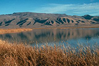
Stillwater National Wildlife Refuge is a National Wildlife Refuge of the United States in Nevada. It is located in the Lahontan Valley, near the community of Fallon, sixty miles east of Reno. It was established in 1949 and encompasses 79,570 acres (322.0 km2).
Waubay Wetland Management District is located in the "Coteau des Prairies", or prairie hills region of South Dakota. It includes more than 300 waterfowl production areas (WPAs) in six counties of northeastern South Dakota: Clark, Codington, Day, Grant, Marshall, and Roberts. The WPAs range from 40 acres (16 ha) to more than 1,600 acres (650 ha) in size, comprising a total of 40,000 acres (160 km2). WPAs provide vital wildlife habitat in a landscape of cropland and pasture.
Upper Souris National Wildlife Refuge, located 30 miles (48 km) northwest of Minot, North Dakota, was established in 1935 as a refuge and breeding ground for migratory birds and other wildlife. The refuge straddles 35 miles (56 km) of the picturesque Souris River valley in northern North Dakota. The Souris River basin figures prominently in the cultural and natural history of the North American mid-continent plains and prairies.
The 1,888-acre (7.64 km2) Florence Lake National Wildlife Refuge, in Burleigh County, North Dakota, United States, has almost 1,000 acres (4.0 km2) of virgin native mixed-grass prairie and a 132-acre (0.53 km2) lake. This high quality prairie habitat attracts grassland birds including grassland passerines that are sought by birders visiting the region. Florence Lake National Wildlife Refuge is administered by Long Lake National Wildlife Refuge as an unstaffed satellite refuge.
Long Lake National Wildlife Refuge, located in south-central North Dakota, was established in 1932 as a migratory bird refuge by President Herbert Hoover. The 22,300-acre (90 km2) refuge consists of a 15,000-acre (61 km2) saline basin that is 18 miles (29 km) long and is appropriately named "Long Lake." Long Lake is relatively shallow; it is normally 3–4 feet (0.91–1.22 m) deep. During extended wet periods, Long Lake reaches depths up to 7 feet (2.1 m).
Appert Lake National Wildlife Refuge is a National Wildlife Refuge in Emmons County, North Dakota. It is a privately owned property with refuge easement rights for flooding, and is one of five easement refuges managed under Long Lake National Wildlife Refuge. It is closed to hunting. It was established to provide a stable water area and safe haven for migrating waterfowl in response to declining populations during the Dust Bowl era of the 1930s. The refuge centers on a wooded prairie wetland which provides relatively unique habitat in an agriculturally dominated area. The refuge is used by wood ducks, American wigeon, green-winged teal, mallards, pintails, gadwalls and a host of woodland passerine bird species.
Dakota Lake National Wildlife Refuge is a National Wildlife Refuge in North Dakota. It is managed under Kulm Wetland Management District.
Maple River National Wildlife Refuge is a National Wildlife Refuge in North Dakota. It is managed under Kulm Wetland Management District.
Slade National Wildlife Refuge is a 3,000-acre (12 km2) National Wildlife Refuge in Kidder County, North Dakota. It was established in 1941 when the property was donated by G.T. Slade, a Northern Pacific Railroad executive. It is managed under the Long Lake National Wildlife Refuge. It contains Harker Lake and Upper Harker Lake.

Humboldt Bay National Wildlife Refuge is located on Humboldt Bay, on the California North Coast near the cities of Eureka and Arcata. The refuge exists primarily to protect and enhance wetland habitats for migratory water birds using the bay area, including tens of thousands of shorebirds, ducks, geese, swans, and the black brant. Humboldt Bay National Wildlife Refuge, along with other public and private lands around Humboldt Bay, is one of the key stopovers for the millions of migratory birds that rely on the Pacific Flyway. More than 200 bird species, including 80 kinds of water birds and four endangered species, regularly feed, rest, or nest on the refuge or other areas around the bay.


