
Brandon is a city in Minnehaha County, South Dakota, United States. Brandon is located five miles east of Sioux Falls. The population was 11,048 as of the 2020 census.
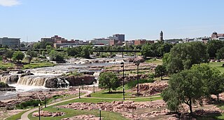
The Big Sioux River is a tributary of the Missouri River in eastern South Dakota and northwestern Iowa in the United States. It flows generally southwardly for 419 mi (674 km), and its watershed is 9,006 sq mi (23,330 km2). The United States Board on Geographic Names settled on "Big Sioux River" as the stream's name in 1931. The river was named after the Lakota people which was known by them as Tehankasandata, or Thick Wooded River.

The Coteau des Prairies is a plateau approximately 200 miles in length and 100 miles in width, rising from the prairie flatlands in eastern South Dakota, southwestern Minnesota, and northwestern Iowa in the United States. The southeast portion of the Coteau comprises one of the distinct regions of Minnesota, known as Buffalo Ridge. The tip of the feature starts in extreme south North Dakota.

Ledges State Park is a state park in Boone County, Iowa, United States, located approximately four miles (6.4 km) south of the city of Boone. The park contains a sandstone gorge carved by Pea's Creek, a tributary of the Des Moines River. The gorge is 100 feet (30 m) deep in places, with concretions jutting from the cliffs.

The Cannon River a tributary of the Mississippi River flows 112 miles (180 km) from Shields Lake near Shieldsville to Red Wing in the U.S. state of Minnesota, where it joins the Mississippi River. It drains a watershed approximately 1460 square miles (3,780 km²) in size. The river flows through the counties of Le Sueur, Rice, Dakota, and Goodhue.

The James River is a tributary of the Missouri River, approximately 710 miles (1,140 km) long, draining an area of 20,653 square miles (53,490 km2) in the U.S. states of North Dakota and South Dakota. About 70 percent of the drainage area is in South Dakota. The river provides the main drainage of the flat lowland area of the Dakotas between the two plateau regions known as the Missouri Coteau and the Coteau des Prairies. This narrow area was formed by the James lobe of the Laurentide Ice Sheet during the last ice age, and as a consequence the watershed of the river is slender and it has few major tributaries for a river of its length.

The Sepulveda Dam is a dry dam constructed by the U.S. Army Corps of Engineers to withhold winter flood waters along the Los Angeles River. Completed in 1941, at a cost of $6,650,561, it is located south of center in the San Fernando Valley, approximately eight miles (13 km) east of the river's source in the western end of the Valley, in Los Angeles, California.

The Loess Hills are a formation of wind-deposited loess soil in the westernmost parts of Iowa and Missouri, and the easternmost parts of Nebraska and Kansas, along the Missouri River.

Minneopa State Park is a state park in the U.S. state of Minnesota. It was established in 1905 to preserve Minneopa Falls, a large waterfall for southern Minnesota, and was expanded in the 1960s to include the lower reaches of Minneopa Creek and a large tract of prairie. Minneopa is Minnesota's third oldest state park, after Itasca and Interstate. Two park resources are listed on the National Register of Historic Places: the 1862 Seppman Mill and a district of seven Rustic Style structures built by the Works Progress Administration in the late 1930s. The park is located almost entirely on the south side of the Minnesota River, three miles (4.8 km) west of Mankato. In 2015 the state reintroduced American bison to the park in a 330-acre (130 ha) fenced enclosure, through which visitors can drive in their vehicles.
Ponca State Park is a public recreation area located on the banks of the Missouri River four miles (6.4 km) north of Ponca, Nebraska, in the northeastern corner of the state. The state park's approximately 2,100 acres (850 ha) are situated among high bluffs and steep, forested hills adjacent to the Missouri National Recreational River. The park is managed by the Nebraska Game and Parks Commission.

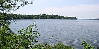
Lewis and Clark Lake is a 31,400 acre (130 km²) reservoir located on the border of the U.S. states of Nebraska and South Dakota on the Missouri River. The lake is approximately 25 miles (40 km) in length with over 90 miles (140 km) of shoreline and a maximum water depth of 45 feet (14 m). The lake is impounded by Gavins Point Dam and is managed by the U.S. Army Corps of Engineers, Omaha District.
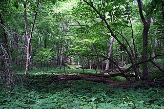
Stone State Park is a state park in Iowa, United States, located in the bluffs and ravines adjacent to the Big Sioux River. The park is located on the northwestern edge of Sioux City and consists of 1,069 acres (433 ha) in Woodbury and Plymouth Counties, and overlooks the South Dakota-Iowa border. Stone Park is near the northernmost extent of the Loess Hills, and is at the transition from clay bluffs and prairie to sedimentary rock hills and bur oak forest along the Iowa side of the Big Sioux River. A variety of prairie plants can be found on the steep slopes and ridges, including yucca, penstemon, rough blazing star, silky aster, and pasque flower. Wild turkey, white-tailed deer, coyote, and red fox are found in the park. Birdlife includes the turkey vulture, barred owl, rufous-sided (eastern) towhee, and the ovenbird. Exposed bedrock in the park is composed of lignite, shale, sandstone, and limestone, and dates to the Cretaceous period; it is rich in marine fossils. The park contains many miles of hiking and equestrian trails, and is a popular destination for day visitors, overnight campers, mountain bike enthusiasts, and picnickers.
The Missouri National Recreational River is a National Recreational River located on the border between Nebraska and South Dakota. The designation was first applied in 1978 to a 59-mile section of the Missouri River between Gavins Point Dam and Ponca State Park. In 1991, an additional 39-mile section between Fort Randall Dam and Niobrara, Nebraska, was added to the designation. These two stretches of the Missouri River are the only parts of the river between Montana and the mouth of the Missouri that remain undammed or unchannelized. The last 20 miles of the Niobrara River and 6 miles of Verdigre Creek were also added in 1991.
Sakatah Lake State Park is an 842-acre (341 ha) state park of Minnesota, USA, on a natural widening of the Cannon River near the town of Waterville. The Dakota native to the area called it "Sakatah" which means "singing hills". To honor this native heritage, some of the trails in the park have been given Dakota names. The Sakatah Singing Hills State Trail, which connects Faribault and Mankato, runs through this park.

Palisades State Park is a state park of South Dakota, USA, featuring cliffs and rock formations eroded out of pink Sioux Quartzite. The park is located just south of Garretson, 10 miles (16 km) off Interstate 90. At only 435 acres (176 ha), it is South Dakota's second-smallest state park.

Lake Francis Case is a large reservoir impounded by Fort Randall Dam on the Missouri River in south-central South Dakota, United States. The lake has an area of 102,000 acres (410 km2) and a maximum depth of 140 ft (43 m). Lake Francis Case has a length of approximately 107 mi (172 km) and has a shoreline of 540 mi (870 km). The lake is the eleventh-largest reservoir in the United States and is located within the counties of: Charles Mix, Gregory, Lyman, Brule, and Buffalo. The lake stretches from Pickstown, South Dakota upstream to Big Bend Dam.

South Dakota is a state located in the north-central United States. It is usually considered to be in the Midwestern region of the country. The state can generally be divided into three geographic regions: eastern South Dakota, western South Dakota, and the Black Hills. Eastern South Dakota is lower in elevation and higher in precipitation than the western part of the state, and the Black Hills are a low, isolated mountain group in the southwestern corner of the state. Smaller sub-regions in the state include the Coteau des Prairies, Missouri Coteau, James River Valley, and the Dissected Till Plains. Geologic formations in South Dakota range in age from two billion-year-old Precambrian granite in the Black Hills to glacial till deposited over the last few million years. South Dakota is the 17th-largest state in the country.
Newton Hills State Park is a South Dakota state park in Lincoln County, South Dakota in the United States. The park is 1,063 acres (430 ha) and sits at an elevation of 1,309 feet (399 m). Newton Hill State Park is open for year-round recreation including camping, swimming, fishing, hiking and boating. It is 12 miles (19 km) east of Interstate 29 and south of Canton.

Lake Kampeska is a 5,250-acre (21 km2) inland glacial lake in the U.S. state of South Dakota. It is located west-northwest of Watertown, South Dakota and lies entirely within Codington County and the Coteau des Prairies. The lake is naturally shaped and the most urban developed lake in South Dakota with approximately 13.5 miles (20 km) of residential shoreline. Lake Kampeska is connected to the Big Sioux River through a single inlet-outlet channel located on the northeast side. It is the third largest natural lake within the borders of South Dakota.
Moose Mountain Upland, Moose Mountain Uplands, or commonly Moose Mountain, is a hilly plateau located in the south-east corner of the Canadian province of Saskatchewan, that covers an area of about 13,000 km2 (5,000 sq mi). The upland rises about 200 m (660 ft) above the broad, flat prairie which is about 600 m (2,000 ft) above sea level. The highest peak is "Moose Mountain" at 830 m (2,720 ft) above sea level. The area was named Moose Mountain because of the large number of moose that lived in the area. When it was originally used by fur traders, Métis, and the Indigenous peoples, the plateau was called Montagne a la Bosse, which is French for "The Mountain of The Bump or Knob."
