1Most severe tornado damage; see Enhanced Fujita scale 2Time from first tornado to last tornado
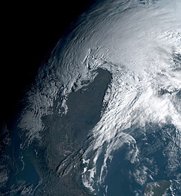
The March 2019 North American blizzard was a powerful Colorado Low that produced up to two feet of snow in the plains and Midwest. Rapid snowmelt following the storm caused historic flooding, and some areas received hurricane-force wind gusts. Comparable to the 1993 Storm of the Century,[1][2] the storm was labeled a bomb cyclone after barometric pressure readings dropped in excess of 24mbar (0.71inHg) over a 24-hour period.[3] After the storm entered Colorado from its origination in Arizona, the pressure dropped more than 30mbar (0.89inHg) and rapidly intensified over the western High Plains.[4] The severe storm set new all-time record low barometric pressure readings in Colorado, Kansas and New Mexico. The storm itself killed only one person in Colorado, but flooding caused by the storm killed at least 3, one in Iowa and at least two in Nebraska[5][6] and left ~140,000 without power in Texas.[7]
The system originated from an extratropical low that developed in the Gulf of Alaska on March 8. Over the next two days, the system moved southeastward, bringing rainy and windy conditions to California on March 11, and the system was named "Winter Storm Ulmer" by The Weather Channel later that day, due to the storm's expected impacts. Early on March 12, the system moved onshore in Southern California, subsequently developing into a strong Colorado Low over the Southwestern United States. Late on March 12 through early March 13, the already-unusually strong Colorado low underwent explosive intensification, with the storm's minimum central pressure falling from 994mbar (29.4inHg) to 968mbar (28.6inHg) in roughly 16 hours, more than meeting the criteria for a weather bomb or "bomb cyclone" (a storm that undergoes a pressure drop of at least 24mbar (0.71inHg) in 24 hours[8]). The storm's tight pressure gradient allowed wind gusts in excess of 100mph to develop in the Texas Panhandle. As the storm headed northward towards the Great Lakes, blizzard conditions were reported in several States, from Colorado all the way north into North Dakota and flooding hit the southern portions of those states. The storm also began weakening.[9]
At least 1 million acres of U.S. farmland, in nine major grain producing states, were flooded after the storm.[10]
Alabama
Severe weather damage was widespread throughout the state, mainly from the 13tornadoes that touched down on March14. The strongest was an EF2tornado, that passed north Holtville and continued to just southwest of Weoka, destroying or damaging outbuildings, homes, convenience stores, power poles, and trees along its path. A car was also moved 30 yards (27m). In Fayette, 1.75 inches (4.4cm) was reported while damaging winds knocked down numerous trees and power lines. Winds of 75 miles per hour (121km/h) were reported near both Leola and Loveless.[11]
Colorado
The storm underwent explosive cyclogenesis as it tracked across the Southern Rocky Mountains.[8]Colorado experienced heavy snow and hurricane-force wind gusts from the blizzard, up to as much as 110 miles per hour (180km/h).[8]6 to 10 inches (150 to 250mm) of snow was recorded in the Denver region with 20in (510mm) reported in Nederland.[12] The storm brought wind gusts that exceeded Category2 hurricane strength with gusts reaching 96 miles per hour (154km/h) recorded at Peterson Air Force Base and a 92mph (148km/h) gust recorded in Glen Haven. A Category1 force wind gust of 80mph (130km/h) was reported at Denver International Airport.[8][13] The combination of high winds and snowy conditions forced the cancellation of all flights in and out of Denver International Airport most of the day March13 and a third of the flights scheduled for March 14th.[14] The rapid intensification of the storm over Colorado set a new all-time record low pressure record of 970.4mbar (28.66inHg) in Lamar, which is somewhat lower than the previous record for Colorado set in 1973 at 973.4mbar (28.74inHg).[15] Numerous vehicular accidents were reported with at least 1,000 people stranded on the highways, requiring rescue by the National Guard and emergency services providers. A Colorado State Patrol officer was killed by one driver who lost control of his vehicle on Interstate 76 northeast of Denver.[16]
Iowa
Iowa was also affected by heavy rains and flooding, closing parts of all nine state parks. Iowa Governor Kim Reynolds signed an emergency disaster proclamation March 14th.[17] One man was killed in Iowa.[6] Flooding across Iowa was described as "catastrophic" especially in the Missouri River Valley south of Council Bluffs, Iowa. There, at least 30 levee failures flooded towns and highways. Interstate 29 was closed from Council Bluffs to the Missouri state border and from there to St. Joseph, Missouri, with portions of the interstate under 15ft (4.6m) of water.[18]
The state was affected by severe thunderstorms that produced several tornadoes. Most notably, an EF2tornado spotted near West Paducah, strong enough to rip part of the roof off of the Mount Zion church. Other tornadoes were also spotted, one in Morgansfield and the other 7 miles (11km) north of Corydon.
Kansas
Meteorologists were forecasting a record low barometric pressure reading as the storm passed over Kansas. The current record set in 1878 at 971.6mbar (28.69inHg) and the storm was forecast to have a slightly lower reading, the equivalent of a Category 2 Hurricane.[19]Dodge City, Kansas reported a new record low pressure.[citation needed]
Upwards of 70buildings in Vernon were damaged by an EF2tornado late on March14. Strong winds and flooding also affected the state.
Nebraska
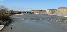
The Spencer dam as seen in 2010 was destroyed by flooding waters of the Niobrara River
Western Nebraska experienced severe wind gusts and more than a foot of snow in some localities. A wind gust of 89mph (143km/h) was recorded in Hemingford, Nebraska and Interstate 80 was closed from Kearney, Nebraska to the Wyoming border. The Interstate 80 closure in Nebraska along with the portions closed in Wyoming spanned a distance of more than 500 miles (800km).[20] In the eastern half of the state, rapidly melting snows along with frozen rivers caused record setting flooding in many rivers and streams. On the Niobrara River, the Spencer Dam collapsed and the unregulated flooding destroyed 3 bridges downstream including the Highway 281 bridge.[21] In east central Nebraska, residents along the flooded Missouri, Platte and Elkhorn Rivers were forced to evacuate as some locals experienced all-time record flooding. The city of Norfolk, Nebraska evacuated a third of its residents.[22] The Platte and Elkhorn Rivers had overflowed their levees in the greater Omaha, Nebraska region and some communities were put under a mandatory evacuation order. The Platte River at numerous sites had reached flooding of "historical proportions" with some sites breaking all-time record flood levels by as much as 5 feet (1.5m).[23] By March 15, access to the city of Fremont was blocked due to all roads being closed in and out of the city.[24] This remained the case days later with national guard military convoys being set up to get food and other supplies into the city. Offutt Air Force Base had extensive flooding from the Platte River and 3,000ft (910m) of their only runway was covered in water while 30 buildings had been flooded.[25] As of March 18, 2 persons were reported to have drowned in Nebraska and 2 more are missing and presumed dead.[6] On March 18, Nebraska governorPete Ricketts stated that the floods caused "the most extensive damage our state has ever experienced."[26] Losses from flooding in Nebraska alone exceeds $1.3 Billion, including $449 million in infrastructure damage, $440 million of crop damage, $400 million of lost cattle. More than 2,000 homes and 340 businesses were damaged or destroyed, costing the state another $85 million.[27]
In the central parts of Nebraska, large ice slabs were reported to have destroyed crops, and Sub-Zero conditions often hurt livestock. An additional round of Flooding is said to have wiped out some farms for years.[28]
New Mexico
A new all-time low barometric pressure reading for New Mexico was set in Clayton and wind gusts of 100mph (160km/h) were recorded in Cloudcroft, New Mexico.[29] In addition, powerful thunderstorms moving through the state spawned several tornadoes, damaging many homes.
Oklahoma
A high wind warning was issued by the National Weather Service as thunderstorms with 50mph (80km/h) wind gusts downed power lines, tree branches, some fences, and caused other kinds of minor wind damage across Oklahoma City and its suburbs.[30]
South Dakota
The City of Pierre achieved full on blizzard conditions (frequent wind gusts above 35mph/56km/h producing visibility lower than 1/4 mile/400 metres for at least 3 hours). These conditions prompted the closure of the I-90 from Wall to Chamberlain. 18.3 inches (46cm) of snow fell in Kadoka and winds gusted to 70mph (112km/h) in Rapid City.[31]
Blizzard conditions were reported for all of eastern Wyoming, especially in the southeastern sections of the state from Casper to the state capital in Cheyenne. Snowfalls in excess of one foot were recorded in several locations with wind gusts of 76mph (122km/h) in Carbon County. Both Interstate 25 and Interstate 80 were closed through most of the state.[33]
An additional snow squall moved across Southeast Wyoming Friday through Sunday, adding 1-2 inches of snow. Due to the location of the low, many areas were above freezing and had rain instead, which prompted the NWS to issue Flood watches and warnings in the area.[34]
Canada
Atlantic Canada
The storm brought above seasonal temperatures to much of Atlantic Canada, along with soaking rains. Although, Labrador was affected by heavy snow with up to 30cm (1 foot) of snow in some areas. Afterwards, the storm moved out to sea.[35]
Ontario and Quebec
The provinces experienced their warmest day in weeks, sparking the risk for isolated severe thunderstorms in extreme southwestern Ontario. These storms triggered flooding along the Humber River, resulting in an evacuation order for 200 people.[36] Behind the storm's cold front, cold, below seasonal temperatures returned along with snowsqualls in the snow belts. Meanwhile, Northern Ontario was hit with heavy snow and strong winds, producing blizzard-like conditions.[37]
A strong tornado touched down near Hagerman before moving northward and striking the town of Dexter. Six homes or mobile homes in Dexter were severely damaged or destroyed, while an additional dozen others suffered minor to moderate damage. An RV camper was tossed and destroyed, and debris was scattered throughout the town and wrapped around power lines. Trees and power lines were downed, and pivot irrigation sprinklers were destroyed outside of town. Six people were injured. This was the earliest EF1 or stronger tornado in the state of New Mexico on record and also the first tornado in Chaves County during the month of March going back to 1959.
Homes and mobile homes sustained roof damage as a result of this high-end EF1 tornado, including one frame home that sustained collapse of its attached garage. A mobile home was flipped upside down, and an overhead door was bowed out at a metal building. Power poles were damaged, street signs were bent to the ground, and a small outbuilding was blown across a road and destroyed. A large 300ft (91m) tall communications tower was toppled, though the structure was determined to have been top-heavy. Trees were snapped, and an empty fiberglass storage tank was blown over as well.
A large metal building was destroyed, a single family residence suffered significant damage, and a center pivot was damaged as well. Trees and powerlines were snapped.
Storage sheds and an awning in town were damaged by this brief tornado. A power pole was snapped at its base while a nearby home had its windows blown out.
This tornado touched down immediately after the previous tornado lifted in Junction. Several roofs were ripped off, windows were blown out, and trees and power lines were damaged. A piece of wood was impaled into the exterior wall of a residence, and a deer feeder lid was lodged into the side of a business. An overhead door was blown out at a fire station.
A small residence in Zephyr was overturned and tossed 50ft (15m) from its foundation. Several roofs were ripped off, awnings and power lines were destroyed, power poles were snapped, and the brick wall was blown out of a store. Trees and a grandstand were damaged.
A manufacturing storage building lost some sheet metal roofing. A commercial automotive repair center suffered significant roof and wall damage. Damage to signs, utility poles, and trees occurred as well.
A site-built frame home had most of its roof removed. A nearby metal-clad commercial building saw its metal roof cross members severely twisted and most of its sheet metal roofing ripped off. Trees and outbuildings were damaged.
This strong tornado first passed near the towns of Lovelaceville, Massac, and Camelia, causing significant damage to at least a dozen homes, including a few with roof loss and some exterior walls ripped off. Dozens of barns, outbuildings, garages, and grain bins were also destroyed. A church had most of its roof and a second-story exterior wall torn off, and vehicles were damaged by flying debris in the parking lot. A business was heavily damaged, a pontoon boat was thrown 120yd (110m), and a mobile home was rolled and destroyed. The tornado weakened as it struck West Paducah, where a mall and an adjacent strip mall sustained damage to their roofs and metal fascia. Other businesses had roofing and siding peeled off, a semi-truck was blown over, fences were downed, and signs were damaged as well. Dozens of power poles were blown down, and hundreds of trees were snapped or uprooted along the path. Over a dozen vehicles were damaged. One injury occurred when a grain bin was blown on top of a pickup truck. This tornado passed very close to the National Weather Service office in Paducah, and was caught on video by a meteorologist on duty.
A semi-truck was blown over, resulting in minor injuries to the driver. Dozens of trees were snapped or uprooted, several power poles were toppled, and a farm building had a portion of its roof ripped off. A car, a trailer, and a second semi-trailer were blown upside down as well.
A low-hanging wall cloud produced a tornado that intermittently reached the ground, snapping several treetops. A nearby barn sustained significant damage.
Some shingle damage was inflicted to a home and one utility pole was snapped, with others damaged. Most of the damage was limited to fallen trees. The tornado was first tornado in Lake County since 2014 and the earliest in the calendar year for the county since 1976.
A small hay barn was completely destroyed and several outbuildings were damaged. A community center had portions of its roof lifted up and sheets of its metal roofing peeled back. One former chicken house used as a storage building had its entire roof ripped off while a second chicken house suffered moderate damage. Trees were snapped and uprooted.
A mobile home park in Allgood suffered extensive damage from falling trees, with some mobile homes destroyed. A barn and an outbuilding were destroyed, and several frame homes sustained minor roof damage. Past Allgood, minor roof and structural damage occurred, and farm structures were damaged, including chicken houses that had sheet metal roofing peeled off. Numerous soft and hardwood trees were either snapped or uprooted along the path, some of which landed on vehicles and houses.
A significant tornado touched down near Perry before passing near Morrice. 10 mobile homes were damaged by falling trees in this area, and frame homes sustained roof damage and broken windows. North of Bancroft, the tornado intensified and inflicted severe structural damage to several homes, including a two-story house that sustained total roof removal and collapse of a second floor exterior wall. Additional major damage occurred at the southeastern fringes of Vernon, where multiple homes sustained severe roof and wall damage, and a fabrication business was destroyed. Housing insulation from Vernon was found up to 7mi (11km) away. Barns and outbuildings were destroyed along the path, and trees and power lines were downed. The tornado was the first to impact Shiawassee County since June2015.
One mobile home was flipped onto its side and a second was partially blown off its foundation. Other homes suffered roof and siding damage. Trees were snapped, and a couple of small trailers were flipped.
Two homes were damaged. One had its carport collapsed and portions of its roof and a nearby building peeled back. The second had a significant portion of its metal roof peeled back, and a trampoline was tossed 100yd (91m) over the structure into nearby trees. A shed was destroyed and numerous trees were snapped or uprooted.
A silo and two barn roofs were damaged. Numerous trees were snapped or uprooted, some of which fell on power lines. A gazebo was collapsed, the foundation of a garage was cracked, and doors to a barn and a garage were damaged or collapsed. Several homes had shingles and siding ripped off.
Minor tree damage occurred where the tornado first touched down, along with brick facade damage to a home. Sheet metal was torn off of manufactured homes and outbuildings. Widespread tree damage occurred in heavily forested areas throughout the path of the tornado.
A strong tornado caused significant damage as it passed south of Titus. At least 50 structures were damaged, including several homes that sustained total roof loss and some collapse of exterior walls. At least 35power poles were snapped or downed, and numerous trees were snapped or uprooted, including a large swath of trees that was completely flattened in a convergent pattern. Two convenience stores were damaged, with a gas station canopy toppled over onto one of them. Outbuildings were destroyed, and a car was tossed over 30yd (27m) as well.
1993 Storm of the Century – An extremely powerful extratropical cyclone that brought blizzard conditions to extensive portions of the Eastern U.S. in March 1993
↑ Randall, Doug. “National Weather Service Warns Of Southeast Wyoming Flooding.” KGAB AM 650, 20 Mar. 2019, kgab.com/national-weather-service-warns-of-southeast-wyoming-flooding/.
↑ "New Mexico Event Report: EF2 Tornado". National Centers for Environmental Information. National Weather Service Weather Forecast Office in Albuquerque, New Mexico. 2019. Retrieved June 18, 2019.
↑ "New Mexico Event Report: EF2 Tornado". National Centers for Environmental Information. National Weather Service Weather Forecast Office in Midland/Odessa, Texas. 2019. Retrieved June 18, 2019.
↑ "Texas Event Report: EF1 Tornado". National Centers for Environmental Information. National Weather Service Weather Forecast Office in Midland/Odessa, Texas. 2019. Retrieved June 18, 2019.
↑ "Texas Event Report: EF1 Tornado". National Centers for Environmental Information. National Weather Service Weather Forecast Office in Lubbock, Texas. 2019. Retrieved June 18, 2019.
↑ "Texas Event Report: EFU Tornado". National Centers for Environmental Information. National Weather Service Weather Forecast Office in Lubbock, Texas. 2019. Retrieved June 18, 2019.
↑ "Texas Event Report: EF0 Tornado". National Centers for Environmental Information. National Weather Service Weather Forecast Office in San Angelo, Texas. 2019. Retrieved June 18, 2019.
↑ "Texas Event Report: EF0 Tornado". National Centers for Environmental Information. National Weather Service Weather Forecast Office in San Angelo, Texas. 2019. Retrieved June 18, 2019.
↑ "Texas Event Report: EF1 Tornado". National Centers for Environmental Information. National Weather Service Weather Forecast Office in San Angelo, Texas. 2019. Retrieved June 18, 2019.
↑ "Texas Event Report: EF1 Tornado". National Centers for Environmental Information. National Weather Service Weather Forecast Office in Fort Worth-Dallas, Texas. 2019. Retrieved June 18, 2019.
↑ "Texas Event Report: EF1 Tornado". National Centers for Environmental Information. National Weather Service Weather Forecast Office in Fort Worth-Dallas, Texas. 2019. Retrieved June 18, 2019.
↑ "Kentucky Event Report: EF1 Tornado". National Centers for Environmental Information. National Weather Service Weather Forecast Office in Paducah, Kentucky. 2019. Retrieved June 18, 2019.
↑ "Kentucky Event Report: EF2 Tornado". National Centers for Environmental Information. National Weather Service Weather Forecast Office in Paducah, Kentucky. 2019. Retrieved June 18, 2019.
↑ "Kentucky Event Report: EF2 Tornado". National Centers for Environmental Information. National Weather Service Weather Forecast Office in Paducah, Kentucky. 2019. Retrieved June 18, 2019.
↑ "Kentucky Event Report: EF1 Tornado". National Centers for Environmental Information. National Weather Service Weather Forecast Office in Paducah, Kentucky. 2019. Retrieved June 18, 2019.
↑ "Kentucky Event Report: EF0 Tornado". National Centers for Environmental Information. National Weather Service Weather Forecast Office in Paducah, Kentucky. 2019. Retrieved June 18, 2019.
↑ "Kentucky Event Report: EF0 Tornado". National Centers for Environmental Information. National Weather Service Weather Forecast Office in Paducah, Kentucky. 2019. Retrieved June 18, 2019.
↑ "Kentucky Event Report: EF0 Tornado". National Centers for Environmental Information. National Weather Service Weather Forecast Office in Paducah, Kentucky. 2019. Retrieved June 18, 2019.
↑ "Kentucky Event Report: EF0 Tornado". National Centers for Environmental Information. National Weather Service Weather Forecast Office in Paducah, Kentucky. 2019. Retrieved June 18, 2019.
↑ "Indiana Event Report: EF1 Tornado". National Centers for Environmental Information. National Weather Service Weather Forecast Office in Indianapolis, Indiana. 2019. Retrieved January 16, 2020.
↑ "Indiana Event Report: EF0 Tornado". National Centers for Environmental Information. National Weather Service Weather Forecast Office in Louisville, Kentucky. 2019. Retrieved June 18, 2019.
↑ "Kentucky Event Report: EF0 Tornado". National Centers for Environmental Information. National Weather Service Weather Forecast Office in Paducah, Kentucky. 2019. Retrieved June 18, 2019.
↑ "Indiana Event Report: EF0 Tornado". National Centers for Environmental Information. National Weather Service Weather Forecast Office in Chicago, Illinois. 2019. Retrieved June 18, 2019.
↑ "Alabama Event Report: EF1 Tornado". National Centers for Environmental Information. National Weather Service Weather Forecast Office in Huntsville, Alabama. 2019. Retrieved June 18, 2019.
↑ "Alabama Event Report: EF0 Tornado". National Centers for Environmental Information. National Weather Service Weather Forecast Office in Birmingham, Alabama. 2019. Retrieved June 18, 2019.
↑ "Alabama Event Report: EF1 Tornado". National Centers for Environmental Information. National Weather Service Weather Forecast Office in Birmingham, Alabama. 2019. Retrieved June 18, 2019.
↑ "Alabama Event Report: EF0 Tornado". National Centers for Environmental Information. National Weather Service Weather Forecast Office in Birmingham, Alabama. 2019. Retrieved June 18, 2019.
↑ "Alabama Event Report: EF0 Tornado". National Centers for Environmental Information. National Weather Service Weather Forecast Office in Birmingham, Alabama. 2019. Retrieved June 18, 2019.
↑ "Alabama Event Report: EF0 Tornado". National Centers for Environmental Information. National Weather Service Weather Forecast Office in Birmingham, Alabama. 2019. Retrieved June 18, 2019.
↑ "Michigan Event Report: EF2 Tornado". National Centers for Environmental Information. National Weather Service Weather Forecast Office in Detroit/Pontiac, Michigan. 2019. Retrieved June 18, 2019.
↑ "Michigan Event Report: EF0 Tornado". National Centers for Environmental Information. National Weather Service Weather Forecast Office in Detroit/Pontiac, Michigan. 2019. Retrieved June 18, 2019.
↑ "Alabama Event Report: EF1 Tornado". National Centers for Environmental Information. National Weather Service Weather Forecast Office in Birmingham, Alabama. 2019. Retrieved June 18, 2019.
↑ "Michigan Event Report: EF0 Tornado". National Centers for Environmental Information. National Weather Service Weather Forecast Office in Detroit/Pontiac, Michigan. 2019. Retrieved June 18, 2019.
↑ "Alabama Event Report: EF0 Tornado". National Centers for Environmental Information. National Weather Service Weather Forecast Office in Birmingham, Alabama. 2019. Retrieved June 18, 2019.
↑ "Alabama Event Report: EF0 Tornado". National Centers for Environmental Information. National Weather Service Weather Forecast Office in Birmingham, Alabama. 2019. Retrieved June 18, 2019.
↑ "Michigan Event Report: EF0 Tornado". National Centers for Environmental Information. National Weather Service Weather Forecast Office in Detroit/Pontiac, Michigan. 2019. Retrieved June 18, 2019.
↑ "Alabama Event Report: EF1 Tornado". National Centers for Environmental Information. National Weather Service Weather Forecast Office in Birmingham, Alabama. 2019. Retrieved June 18, 2019.
↑ "Alabama Event Report: EF0 Tornado". National Centers for Environmental Information. National Weather Service Weather Forecast Office in Birmingham, Alabama. 2019. Retrieved June 18, 2019.
↑ "Alabama Event Report: EF0 Tornado". National Centers for Environmental Information. National Weather Service Weather Forecast Office in Birmingham, Alabama. 2019. Retrieved June 18, 2019.
↑ "Georgia Event Report: EF0 Tornado". National Centers for Environmental Information. National Weather Service Weather Forecast Office in Peachtree City/Atlanta, Georgia. 2019. Retrieved June 18, 2019.
↑ "Ohio Event Report: EF0 Tornado". National Centers for Environmental Information. National Weather Service Weather Forecast Office in Cleveland, Ohio. 2019. Retrieved June 18, 2019.
↑ "Ohio Event Report: EF0 Tornado". National Centers for Environmental Information. National Weather Service Weather Forecast Office in Cleveland, Ohio. 2019. Retrieved June 18, 2019.
↑ "Alabama Event Report: EF0 Tornado". National Centers for Environmental Information. National Weather Service Weather Forecast Office in Birmingham, Alabama. 2019. Retrieved June 18, 2019.
↑ "Alabama Event Report: EF0 Tornado". National Centers for Environmental Information. National Weather Service Weather Forecast Office in Birmingham, Alabama. 2019. Retrieved June 18, 2019.
↑ "Alabama Event Report: EF0 Tornado". National Centers for Environmental Information. National Weather Service Weather Forecast Office in Birmingham, Alabama. 2019. Retrieved June 18, 2019.
↑ "Alabama Event Report: EF0 Tornado". National Centers for Environmental Information. National Weather Service Weather Forecast Office in Birmingham, Alabama. 2019. Retrieved June 18, 2019.
↑ "Alabama Event Report: EF0 Tornado". National Centers for Environmental Information. National Weather Service Weather Forecast Office in Birmingham, Alabama. 2019. Retrieved June 18, 2019.
↑ "Alabama Event Report: EF1 Tornado". National Centers for Environmental Information. National Weather Service Weather Forecast Office in Birmingham, Alabama. 2019. Retrieved June 18, 2019.
↑ "Alabama Event Report: EF2 Tornado". National Centers for Environmental Information. National Weather Service Weather Forecast Office in Birmingham, Alabama. 2019. Retrieved June 18, 2019.
↑ "Alabama Event Report: EF0 Tornado". National Centers for Environmental Information. National Weather Service Weather Forecast Office in Birmingham, Alabama. 2019. Retrieved June 18, 2019.
This page is based on this Wikipedia article Text is available under the CC BY-SA 4.0 license; additional terms may apply. Images, videos and audio are available under their respective licenses.