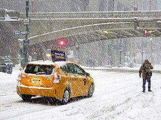
A winter storm is an event in which wind coincides with varieties of precipitation that only occur at freezing temperatures, such as snow, mixed snow and rain, or freezing rain. In temperate continental climates, these storms are not necessarily restricted to the winter season, but may occur in the late autumn and early spring as well. A snowstorm with strong winds and other conditions meeting certain criteria is called a blizzard.
A winter storm warning is a hazardous weather statement issued by Weather Forecast Offices (WFO) of the National Weather Service (NWS) in the United States to alert the public that a winter storm is occurring or is about to occur in the area, usually within 36 hours of the storm's onset.

The North American blizzard of 1996 was a severe nor'easter that paralyzed the United States East Coast with up to 4 feet (1.2 m) of wind-driven snow from January 6 to January 8, 1996. The City University of New York reported that the storm "dropped 20 inches of snow, had wind gusts of 50 mph and snow drifts up to 8 feet high." This storm was a classic example of a nor'easter, but the storm would not have been as historically significant without the presence of the arctic high pressure system located to the north of New York. It was followed by another storm, an Alberta Clipper, on January 12, then unusually warm weather and torrential rain which caused rapid melting and river flooding in the Northeast Floods later that month. Along with the March Superstorm of 1993 and the January 2016 United States blizzard, it is one of only three snowstorms to receive the top rating of 5, or "Extreme", on the Northeast Snowfall Impact Scale (NESIS).

The North American blizzard of 2006 was a nor'easter that began on the evening of February 11, 2006. It dumped heavy snow across the Mid-Atlantic and New England states, from Virginia to Maine through the early evening of February 12, and ended in Atlantic Canada on February 13. The major cities from Baltimore to Boston received at least a foot of snow, with a second-highest amount of 26.9 inches (68 cm) in New York City, the most since at least 1869, the start of record keeping, only broken by the January 2016 United States blizzard nearly 10 years later.

A historic snowstorm struck the Ohio Valley of the United States, as well as Ontario in Canada, on December 22 and December 23 and is not the same storm that led to snow in Texas on Christmas Eve. It lasted roughly 30 hours, and brought snowfall amounts up to 29 inches (74 cm) to portions of the Midwestern United States. Damages from the storm totaled US$900 million (2004 dollars). A total of 18 died during the storm, one from Canada, mainly due to car accidents.

It is very rare for snow to fall in the U.S. state of Florida, especially in the central and southern portions of the state. With the exception of the far northern areas of the state, most of the major cities in Florida have never recorded measurable snowfall, though trace amounts have been recorded, or flurries in the air observed few times each century. According to the National Weather Service, in the Florida Keys and Key West there is no known occurrence of snow flurries since the European colonization of the region more than 300 years ago. In Miami, Fort Lauderdale, and Palm Beach there has been only one known report of snow flurries observed in the air in more than 200 years; this occurred in January 1977. In any event, Miami, Fort Lauderdale, and Palm Beach have not seen snow flurries before or since this 1977 event.

The February 2007 North American blizzard was a massive winter storm that affected most of the eastern half of North America, starting on February 12, 2007 and peaking on Valentine's Day, February 14. The storm produced heavy snowfalls across the midwestern United States from Nebraska to Ohio and produced similar conditions across parts of the northeastern United States, and into Canada in Ontario, Quebec and New Brunswick. Significant sleet and freezing rain fell across the southern Ohio Valley and affected portions of the east coast of the United States, including the cities of Boston, Baltimore, Washington, D.C., New York City and Philadelphia.

The February 9–10, 2010 North American blizzard was a winter and severe weather event that afflicted the Midwest, Mid-Atlantic and New England regions of the United States between February 9–11, 2010, affecting some of the same regions that had experienced a historic Nor'easter three days prior. The storm brought 10 to 20 inches of snow across a wide swath from Washington, DC to New York City, with parts of the Baltimore metro area receiving more than 20 inches (51 cm). This storm began as a classic "Alberta clipper", starting out in Canada and then moving southeast, and finally curving northeast while rapidly intensifying off the New Jersey coast, forming an eye. The National Weather Service, in an interview with The Baltimore Sun's weather reporter Frank Roylance, likened this storm to a Category 1 hurricane. Forecasters told Roylance that "Winds topped 58 mph over part of the Chesapeake Bay, and 40 mph gusts were common across the region as the storm's center deepened and drifted slowly along the mid-Atlantic coast". This storm system, in conjunction with the first storm 3 days prior, has been nicknamed Snoverkill.

Global storm activity of 2008 profiles the major worldwide storms, including blizzards, ice storms, and other winter events, from January 1, 2008 to December 31, 2008. A winter storm is an event in which the dominant varieties of precipitation are forms that only occur at cold temperatures, such as snow or sleet, or a rainstorm where ground temperatures are cold enough to allow ice to form. It may be marked by strong wind, thunder and lightning, heavy precipitation, such as ice, or wind transporting some substance through the atmosphere. Major dust storms, Hurricanes, cyclones, tornados, gales, flooding and rainstorms are also caused by such phenomena to a lesser or greater existent.
Global weather activity of 2007 profiles the major worldwide weather events, including blizzards, ice storms, tornadoes, tropical cyclones, and other weather events, from January 1, 2007, to December 31, 2007. Winter storms are events in which the dominant varieties of precipitation are forms that only occur at cold temperatures, such as snow or sleet, or a rainstorm where ground temperatures are cold enough to allow ice to form. It may be marked by strong wind, thunder and lightning, heavy precipitation, such as ice, or wind transporting some substance through the atmosphere. Other major non winter events such as large dust storms, Hurricanes, cyclones, tornados, gales, flooding and rainstorms are also caused by such phenomena to a lesser or greater existent.

The December 1969 nor'easter was a strong winter storm that mainly affected the Northeastern United States and southern Quebec between December 25 and December 28, 1969. The multi-faceted storm system included a tornado outbreak, record snow accumulations, a damaging ice storm, and flooding rains.

The February 2014 nor'easter was a major nor'easter that produced a damaging snow and ice storm that affected the Southern United States and East Coast of the United States, bringing with it up to a foot of snow and crippling ice across parts of the South. Thousands if not hundreds of thousands of people were left in the dark for days, possibly even up to 2 weeks without power. Delta Air Lines canceled over 2,000 flights, and it was reported by 8:00 p.m. Thursday, February 13, that as many as 6,500 flights originating in or destined for the United States had been canceled. On that day 70 percent of flights were cancelled at airports in Baltimore, Philadelphia, Washington, D.C., and Charlotte.

The 2013–14 North American winter was one of the most significant for the United States, due in part to the breakdown of the polar vortex in November 2013, which allowed very cold air to travel down into the United States, leading to an extended period of very cold temperatures. The pattern continued mostly uninterrupted throughout the winter and numerous significant winter storms affected the Eastern United States, with the most notable one being a powerful winter storm that dumped ice and snow in the Southeastern United States and the Northeastern United States in mid-February. Most of the cold weather abated by the end of March, though a few winter storms did affect the Western United States towards the end of the winter.

The 2014–15 North American winter was frigid and prolifically wintry, especially across the eastern half of North America in the months of January–March. The season began early, with many places in North America experiencing their first wintry weather during mid-November. A period of below-average temperatures affected much of the contiguous United States, and several records were broken. An early trace of snowfall was recorded in Arkansas. There were greater accumulations of snow across parts of Oklahoma as well. A quasi-permanent phenomenon referred to as the polar vortex may have been partly responsible for the cold weather. Temperatures in much of the United States dropped 15 to 35 °F below average by November 19, following a southward "dip" of the polar vortex into the eastern two-thirds of the country. The effects of this dip were widespread, bringing about temperatures as low as 28 °F (−2 °C) in Pensacola, Florida. Following a significant snowstorm there, Buffalo, New York received several feet of snow from November 17–21. In addition, significant winter weather occurred throughout the season, including a major blizzard that struck the Northeastern United States at the end of January, another blizzard that affected much of the Northern United States days later in early February, and several significant snow events paired with very frigid temperatures for much of February.

The 2011–12 North American winter by and large saw above normal average temperatures across North America, with the Contiguous United States encountering its fourth-warmest winter on record, along with an unusually low number of significant winter precipitation events. The primary outlier was Alaska, parts of which experienced their coldest January on record.
The February 2015 Southeastern United States winter storm was a rare winter storm that dumped up to a foot of snow in the Southeast, an area that rarely receives such heavy snowfall. Forming out of a shortwave trough that developed over Texas near the Gulf of Mexico on February 24, the storm quickly made its way over the southern United States, coalescing into a surface low-pressure area as it did so. With arctic air unusually far south, this helped spawn heavy, wet snowfall across the northern portions of several southern states, including the suburbs of Atlanta, Georgia. States such as Alabama and Georgia declared a state of emergency in the northern portions of the state due to the possibility of up to 6 inches (15 cm) of snow, which was normally never seen.

The 2018–19 North American winter was unusually cold within the Northern United States, with frigid temperatures being recorded within the middle of the season. Several notable events occurred, such as a rare snow in the Southeast in December, a strong cold wave and several major winter storms in the Midwest, and upper Northeast and much of Canada in late January and early February, record snowstorms in the Southwest in late February, deadly tornado outbreaks in the Southeast and a historic mid-April blizzard in the Midwest, but the most notable event of the winter was a record-breaking bomb cyclone that affected much of the Central United States and Canada in mid-March. Unlike previous winters, a developing weak El Niño was expected to influence weather patterns across North America. Overall, however, winter of 2018–19 was mild along the mid- and lower parts of the East Coast, the West Coast, and most of the southern Plains. Overall, the meteorological winter of 2018-19 became the wettest on record for the United States.
The December 15–17, 2020 nor'easter was a powerful nor'easter that hammered the Northeastern United States and produced widespread swaths of over 1 foot (12 in) of snow in much of the region from December 15–17, 2020, ending a 1,000+ day high-impact snowstorm drought in much of the Mid-Atlantic and coastal New England regions. The system developed out of a weak area of low-pressure that first developed over the Central United States producing some snowfall before moving eastward, and by December 16, a new, dominant area of low pressure began to develop along the Southeast coast. This low steadily deepened as it moved along and impacted the Mid-Atlantic coastline, prompting several winter-related advisories and warnings for much of the Northeast.
The 2020–21 New Year's North American winter storm was a major storm system that brought a wide swath of snow and ice to parts of the High Plains and Central and Northeastern United States during the New Years holiday from December 30–January 2. The system began developing early on December 30, and began spreading wintry precipitation to parts of Texas, coalescing into a low pressure system that formed near the western Gulf of Mexico. The winter storm tracked north and brought heavy snow, ice and strong winds to much of the center of the Midwest and interior parts of the Northeast and New England, causing widespread impacts and travel issues.

A winter storm in late February impacted much of the Southwestern, Southern, Northeastern and Midwestern United States, producing high snow, ice, and sleet accumulations. The winter storm, unofficially named Winter Storm Oaklee by The Weather Channel, prompted the National Weather Service to issue numerous winter weather watches and warnings across much of the country. First impacting California and Arizona, the low-pressure area associated with the winter storm then traversed across the Southern, Midwestern, and Northeastern parts of the country, setting numerous low temperature records and high snowfall accumulations. The winter storm also impacted areas from Texas to Maine. More than 1,000 flights were cancelled, and over 100,000 power outages occurred. The winter storm caused 7 fatalities, all due to car accidents.
