Eddy County, New Mexico

Last updated

Eddy County
Eddy County New Mexico Court House.jpg
Eddy County Courthouse in Carlsbad
Map of New Mexico highlighting Eddy County.svg
Location within the U.S. state of New Mexico
New Mexico in United States.svg
New Mexico's location within the U.S.
Coordinates: 32°28′N104°18′W / 32.47°N 104.3°W / 32.47; -104.3
CountryFlag of the United States.svg United States
StateFlag of New Mexico.svg  New Mexico
FoundedMay 16, 1891
Named for Charles Eddy, a local rancher
Seat Carlsbad
Largest cityCarlsbad
Area
  Total4,198 sq mi (10,870 km2)
  Land4,176 sq mi (10,820 km2)
  Water22 sq mi (60 km2)  0.5%
Population
 (2020)
  Total62,314
  Density15/sq mi (5.7/km2)
Time zone UTC−7 (Mountain)
  Summer (DST) UTC−6 (MDT)
Congressional district 2nd
Website www.co.eddy.nm.us

Eddy County is a county located in the U.S. state of New Mexico. As of the 2020 census, the population was 62,314. [1] Its county seat and largest city is Carlsbad. [2] The county was created in 1891 and later organized in 1892. [3] It is north of the Texas state line.

Contents

Eddy County comprises the Carlsbad-Artesia, NM Micropolitan Statistical Area.

Carlsbad Caverns National Park is located in this county. Eddy County is the location of the Waste Isolation Pilot Plant.

History

In 1866, Charles Goodnight and Oliver Loving drove vast herds of cattle along the Pecos and set up "cow camps" in Seven Rivers and what is now Carlsbad. John Chisum soon joined them and brought an estimated 100,000 head of cattle of his own through the Pecos Valley.

In 1881, Charles B. Eddy came to the area, and with his brother, John, and partner Amos Bissell, developed the Eddy-Bissell Cattle Company. In 1884, the Eddy brothers and Bissell broke ground on the Halagueno Ranch which encompassed an area from Seven Rivers to La Huerta (a suburb of Carlsbad). In 1887, Eddy built the Halagueno diversion ditch on the Pecos, three miles above the site of the Avalon Dam (which was completed in 1890) and incorporated the venture, calling it the Pecos Valley Land and Ditch Company. Eddy was looking to entice Europeans to settle the area, and with the new Halagueno Ranch and the Pecos Valley Land and Ditch Company established, he sought funds from a Swiss bank to help attract them to the clean air and sunny climate.

In 1888, Patrick Garrett (known as the sheriff who had shot Billy the Kid) along with promoter Charles Greene, joined forces with Eddy to design and build a system of canals and flumes to divert water to their ranches and properties. Greene was able to procure investors from the east, one of which was Robert W. Tansill (manufacturer of the "Punch 5 ¢ Cigar"). These men, along with another big investor, J.J. Hagerman, laid the plans for a new town on the west bank of the Pecos River. The men had the town incorporated as Eddy on September 15, 1888.

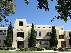
The county was named for cattle rancher Charles B. Eddy. When the territorial legislature set the boundaries of Eddy County, in 1889, Seven Rivers was named the county seat. During an election in 1890 for new county commissioners, a referendum was on the ballot to change the seat from Seven Rivers to the town of Eddy. The referendum passed by a vote of 331 to 83. In that year, the census said Eddy had only 278 people and they cast 241 of the winning votes. The referendum also included the building of a courthouse. Charles Eddy donated the land which consisted of an entire town block. The county commissioners authorized a contract for $30,000 to build a brick courthouse. (In 1899, the town of Eddy changed its name to Carlsbad.)

On January 10, 1891, the first railroad train on the new Pecos Valley Railroad arrived in Eddy, from Pecos, Texas. Crops of cotton and alfalfa (which were found to be the perfect crops for the Eddy County area), along with cattle, sheep, wool, and people, could be moved into and out of the area with ease, now. This brought more investors and many more settlers into the area.

In 1902, Carlsbad Caverns were discovered about 18 mi (29 km) southwest of Carlsbad town. The discovery is still disputed between Jim White and Abijah Long. The caves are now known as Carlsbad Caverns National Park. The caverns have brought many millions of visitors from around the world into Eddy County.

Oil was discovered in Eddy County in 1909, near the town of Dayton (8 mi south of Artesia). Another big oil strike happened in 1923, when Martin Yates Jr., purchased a well near Artesia, and southeastern New Mexico was said to be "gushing oil!". Drilling commenced at a furious pace and by 1938, the area's oil production was valued at $32 million annually.

In 1925, a geologist, Dr. V. H. McNutt, discovered major deposits of potash, while looking for oil east of Carlsbad. This ushered in a "boom" in potash mining, and several large potash producers set up business in the area. [4]

Geography

According to the U.S. Census Bureau, the county has a total area of 4,198 square miles (10,870 km2), of which 4,176 square miles (10,820 km2) is land and 22 square miles (57 km2) (0.5%) is covered by water. [5] The lowest point in the state of New Mexico is located on the Red Bluff Reservoir in Eddy County, where the impounded Pecos River flows out of New Mexico and into Texas.

Adjacent counties

National protected areas

Demographics

Historical population
CensusPop.Note
1910 12,420
1920 9,116−26.6%
1930 15,84273.8%
1940 24,31153.5%
1950 40,64067.2%
1960 50,78325.0%
1970 41,119−19.0%
1980 47,85516.4%
1990 48,6051.6%
2000 51,6586.3%
2010 53,8294.2%
2020 62,31415.8%
U.S. Decennial Census [6]
1790-1960 [7] 1900-1990 [8]
1990-2000 [9] 2010 [10]

2000

As of the 2000 census, [11] 51,658 people, 19,379 households, and 14,069 families resided in the county. The population density was 12 people per square mile (4.6 people/km2). The 22,249 housing units averaged 5 units per square mile (1.9/km2). The racial makeup of the county was 76.34% White, 1.56% Black or African American, 1.25% Native American, 0.45% Asian, 0.09% Pacific Islander, 17.67% from other races, and 2.64% from two or more races. About 38.76% of the population were Hispanic or Latino of any race.

Of the 19,379 households, 35.60% had children under the age of 18 living with them, 56.10% were married couples living together, 11.90% had a female householder with no husband present, and 27.40% were not families. About 24.20% of all households were made up of individuals, and 10.70% had someone living alone who was 65 years of age or older. The average household size was 2.63 and the average family size was 3.12.

In the county, the population was distributed as 28.90% under the age of 18, 8.40% from 18 to 24, 25.70% from 25 to 44, 22.40% from 45 to 64, and 14.70% who were 65 years of age or older. The median age was 36 years. For every 100 females, there were 95.90 males. For every 100 females age 18 and over, there were 92.70 males.

The median income for a household in the county was $31,998, and for a family was $36,789. Males had a median income of $31,909 versus $19,686 for females. The per capita income for the county was $15,823. About 13.60% of families and 17.20% of the population were below the poverty line, including 21.50% of those under age 18 and 13.40% of those age 65 or over.

2010 census

As of the 2010 census, there were 53,829 people, 20,411 households, and 14,292 families residing in the county. [12] The population density was 12.9 inhabitants per square mile (5.0 inhabitants/km2). There were 22,585 housing units at an average density of 5.4 units per square mile (2.1 units/km2). [13] The racial makeup of the county was 77.4% white, 1.5% American Indian, 1.4% black or African American, 0.7% Asian, 16.0% from other races, and 3.0% from two or more races. Those of Hispanic or Latino origin made up 44.1% of the population. [12] In terms of ancestry, 10.8% were German, 8.8% were Irish, 8.5% were English, and 7.0% were American. [14]

Of the 20,411 households, 35.7% had children under the age of 18 living with them, 50.3% were married couples living together, 13.0% had a female householder with no husband present, 30.0% were non-families, and 25.5% of all households were made up of individuals. The average household size was 2.59 and the average family size was 3.08. The median age was 37.3 years. [12]

The median income for a household in the county was $46,583 and the median income for a family was $56,646. Males had a median income of $49,788 versus $30,158 for females. The per capita income for the county was $24,587. About 9.2% of families and 13.6% of the population were below the poverty line, including 16.7% of those under age 18 and 10.6% of those age 65 or over. [15]

Communities

Countryside in Eddy County, 10 miles (16 km) west of Hope Cabinetetc 011.jpg
Countryside in Eddy County, 10 miles (16 km) west of Hope

Cities

Villages

Census-designated places

Ghost Towns

Politics

For much of the first half of the 20th century, Eddy was a Democratic stronghold. Then it became a Republican-leaning swing county until the turn of the century. Since then, it has become a Republican stronghold, like most plains counties. Donald Trump's 2020 performance of over 75% in the county is the strongest victory for any Republican in county history.

United States presidential election results for Eddy County, New Mexico [16]
Year Republican Democratic Third party
No.%No.%No.%
2020 17,45475.16%5,42423.36%3441.48%
2016 13,14766.85%5,03325.59%1,4877.56%
2012 12,58365.30%6,14231.88%5442.82%
2008 12,50062.21%7,35136.58%2421.20%
2004 13,26865.46%6,88033.94%1220.60%
2000 10,33558.10%7,10839.96%3441.93%
1996 8,53444.92%8,95947.16%1,5057.92%
1992 7,31340.18%7,40940.70%3,48019.12%
1988 9,80552.90%8,54446.10%1861.00%
1984 11,81060.99%7,36438.03%1910.99%
1980 9,81756.55%7,02840.49%5142.96%
1976 7,69845.59%9,07353.73%1150.68%
1972 9,92164.65%5,04032.84%3852.51%
1968 7,19347.74%6,09340.44%1,78011.81%
1964 6,74737.42%11,21662.20%690.38%
1960 7,98647.59%8,70751.89%870.52%
1956 6,69145.77%7,82053.50%1070.73%
1952 6,04144.45%7,49555.15%550.40%
1948 2,30523.00%7,59375.77%1231.23%
1944 2,08328.43%5,22871.35%160.22%
1940 1,62524.61%4,96875.23%110.17%
1936 1,02718.93%4,34980.17%490.90%
1932 81818.34%3,56579.95%761.70%
1928 1,61857.11%1,21242.78%30.11%
1924 65828.36%1,52465.69%1385.95%
1920 98237.42%1,61161.39%311.18%
1916 42522.00%1,40272.57%1055.43%
1912 1458.96%93657.85%53733.19%

Education

School districts serving portions of the county include: [17]

See also

Related Research Articles

<span class="mw-page-title-main">La Salle County, Texas</span> County in Texas, United States

La Salle County is a county in Texas. As of the 2020 census, its population was 6,664. Its county seat is Cotulla. The county was created in 1858 and later organized in 1880. It is named for René-Robert Cavelier, Sieur de La Salle, a 17th-century French explorer.

<span class="mw-page-title-main">Santa Fe County, New Mexico</span> County in New Mexico, United States

Santa Fe County is located in the U.S. state of New Mexico. As of the 2020 census, the population was 154,823, making it New Mexico's third-most populous county, after Bernalillo County and Doña Ana County. Its county seat is Santa Fe, the state capital.

<span class="mw-page-title-main">San Miguel County, New Mexico</span> County in New Mexico, United States

San Miguel County is a county in the U.S. state of New Mexico. As of the 2020 census, the population was 27,201. Its county seat is Las Vegas.

<span class="mw-page-title-main">Chaves County, New Mexico</span> County in New Mexico, United States

Chaves County is a county in New Mexico, United States. As of the 2020 census, the population was 65,157. Its county seat is Roswell. Chaves County was named for Colonel Jose Francisco Chaves, a military leader there during the Civil War and later in Navajo campaigns. The county was created by the New Mexico Territorial Legislature on February 25, 1889, out of land from Lincoln County.

<span class="mw-page-title-main">Artesia, California</span> City in California, United States

Artesia is a city in southeast Los Angeles County, California. Artesia was incorporated on May 29, 1959, and is one of Los Angeles County's Gateway Cities. The city has a 2010 census population of 16,522. Artesia is surrounded on the west, south, and east sides by Cerritos, with Norwalk to the north. Artesia is the home of the East West Ice Palace, an ice rink which is co-owned by Michelle Kwan. It was also the childhood home of former First Lady Pat Nixon, who lived there from 1914 to 1931, though the property on which she grew up is now part of neighboring Cerritos.

<span class="mw-page-title-main">Artesia, Mississippi</span> Town in Mississippi, United States

Artesia is a town in Lowndes County, Mississippi. The population was 304 at the 2020 census, down from 440 at the 2010 census.

<span class="mw-page-title-main">Dexter, New Mexico</span> Town in New Mexico, United States

Dexter is a town in Chaves County, New Mexico, United States. The population was 1,266 at the time of the 2010 census.

<span class="mw-page-title-main">Hagerman, New Mexico</span> Town in New Mexico, United States

Hagerman is a town in Chaves County, New Mexico, United States. The population was 1,251 at the 2010 census.

<span class="mw-page-title-main">Lake Arthur, New Mexico</span> Town in New Mexico, United States

Lake Arthur is a town in Chaves County, New Mexico, United States. The population was 436 at the 2010 census.

<span class="mw-page-title-main">Artesia, New Mexico</span> City in New Mexico, United States

Artesia is a city in Eddy County, New Mexico, centered at the intersection of U.S. routes 82 and 285; the two highways serve as the city's Main Street and First Street, respectively. As of the 2020 census, the city population was 12,875.

<span class="mw-page-title-main">Carlsbad, New Mexico</span> City in New Mexico, United States

Carlsbad is a city in and the county seat of Eddy County, New Mexico, United States. As of the 2020 census, the city population was 32,238. Carlsbad is centered at the intersection of U.S. Routes 62/180 and 285, and is the principal city of the Carlsbad-Artesia Micropolitan Statistical Area, which has a total population of 62,314. Located in the southeastern part of New Mexico, Carlsbad straddles the Pecos River and sits at the eastern edge of the Guadalupe Mountains.

<span class="mw-page-title-main">La Huerta, New Mexico</span> Census-designated place in New Mexico, United States

La Huerta, formerly known as Carlsbad North, is an unincorporated area and census-designated place (CDP) in Eddy County, New Mexico, United States. The population was 1,246 at the 2010 census. The community, whose name means "fruit garden" in Spanish, was named after the orchards and garden plots that supplied food to Carlsbad.

<span class="mw-page-title-main">Hope, New Mexico</span> Village in New Mexico, United States

Hope is a village in Eddy County, New Mexico, United States. It is located approximately 20 miles (32 km) west of Artesia on U.S. Route 82. It has had a post office since 1890. As of the 2010 census, the village's population was 105.

<span class="mw-page-title-main">Loving, New Mexico</span> Village in New Mexico, United States

Loving is a village in Eddy County, New Mexico. As of the 2010 census, the village population was 1,413. Loving was settled by Swiss immigrants in the 1890s.

<span class="mw-page-title-main">Eunice, New Mexico</span> City in New Mexico, United States

Eunice is a city in Lea County, New Mexico, United States. The population was 2,922 at the 2010 census.

<span class="mw-page-title-main">Lovington, New Mexico</span> City in New Mexico, United States

Lovington is a city in, and the county seat of, Lea County, New Mexico, United States. The population was 11,009 at the 2010 census, up from 9,471 in 2000.

<span class="mw-page-title-main">La Luz, New Mexico</span> CDP in New Mexico, United States

La Luz is a census-designated place (CDP) in Otero County, New Mexico, United States. The population was 1,615 at the 2000 census. It is located immediately north of Alamogordo and lies in the eastern edge of the Tularosa Basin and on the western flank of the Sacramento Mountains. Until 1848, La Luz was a part of Mexico. The CDP gets its name from the Spanish word for "light."

<span class="mw-page-title-main">Pecos, New Mexico</span> Village in New Mexico, United States

Pecos is a village in San Miguel County, New Mexico, United States. The population was 1,392 at the 2010 census, shrinking slower than other parts of San Miguel County, partly because Pecos is within commuting distance of Santa Fe. The village is built along the Pecos River, which flows from the north out of the Santa Fe National Forest. Notable locations nearby include Pecos National Historical Park, Glorieta Pass, Pecos Benedictine Monastery, and Lisboa Springs Trout Hatchery. It is also an entry point for hunting, fishing, hiking and camping in the Pecos Wilderness. The closest metropolitan area is the Santa Fe metropolitan area, approximately 26 miles (42 km) to the west.

<span class="mw-page-title-main">Christine, Texas</span> Town in Texas, United States

Christine is a town in Atascosa County, Texas, United States. The population was 390 at the 2010 census. It is part of the San Antonio Metropolitan Statistical Area.

<span class="mw-page-title-main">Pecos, Texas</span> City in Texas, United States

Pecos is the largest city in and the county seat of Reeves County, Texas, United States. It is in the valley on the west bank of the Pecos River at the eastern edge of the Chihuahuan Desert, in the Trans-Pecos region of West Texas and just south of New Mexico's border. Its population was 12,916 at the 2020 census. On January 24, 2012, Pecos City appeared on the Forbes 400 as the second-fastest growing small town in the United States. The city is a regional commercial center for ranching, oil and gas production, and agriculture. The city is most recognized for its association with the local cultivation of cantaloupes. Pecos claims to be the site of the world's first rodeo on July 4, 1883.

References

  1. "Eddy County, New Mexico". United States Census Bureau . Retrieved July 3, 2023.
  2. "Find a County". National Association of Counties. Archived from the original on July 4, 2012. Retrieved June 7, 2011.
  3. Long, John H., ed. (2007). "New Mexico: Consolidated Chronology of State and County Boundaries". New Mexico Atlas of Historical County Boundaries. The Newberry Library. Archived from the original on August 22, 2016. Retrieved January 2, 2015.
  4. "About Us" Archived July 24, 2011, at the Wayback Machine . About Eddy County. Retrieved December 6, 2010.
  5. "2010 Census Gazetteer Files". United States Census Bureau. August 22, 2012. Archived from the original on January 1, 2015. Retrieved January 1, 2015.
  6. "U.S. Decennial Census". United States Census Bureau. Retrieved January 1, 2015.
  7. "Historical Census Browser". University of Virginia Library. Retrieved January 1, 2015.
  8. "Population of Counties by Decennial Census: 1900 to 1990". United States Census Bureau. Retrieved January 1, 2015.
  9. "Census 2000 PHC-T-4. Ranking Tables for Counties: 1990 and 2000" (PDF). United States Census Bureau. Archived (PDF) from the original on March 27, 2010. Retrieved January 1, 2015.
  10. "State & Bounty QuickFacts". United States Census Bureau. Archived from the original on June 6, 2011. Retrieved September 29, 2013.
  11. "U.S. Census website". United States Census Bureau . Retrieved January 31, 2008.
  12. 1 2 3 "DP-1 Profile of General Population and Housing Characteristics: 2010 Demographic Profile Data". United States Census Bureau. Archived from the original on February 13, 2020. Retrieved January 24, 2016.
  13. "Population, Housing Units, Area, and Density: 2010 - County". United States Census Bureau. Archived from the original on February 13, 2020. Retrieved January 24, 2016.
  14. "DP02 SELECTED SOCIAL CHARACTERISTICS IN THE UNITED STATES – 2006-2010 American Community Survey 5-Year Estimates". United States Census Bureau. Archived from the original on February 13, 2020. Retrieved January 24, 2016.
  15. "DP03 SELECTED ECONOMIC CHARACTERISTICS – 2006-2010 American Community Survey 5-Year Estimates". United States Census Bureau. Archived from the original on February 13, 2020. Retrieved January 24, 2016.
  16. Leip, David. "Dave Leip's Atlas of U.S. Presidential Elections". uselectionatlas.org. Retrieved April 1, 2018.
  17. "2020 CENSUS - SCHOOL DISTRICT REFERENCE MAP: Eddy County, NM" (PDF). U.S. Census Bureau. Archived (PDF) from the original on June 28, 2022. Retrieved June 28, 2022. - Text list

32°28′N104°18′W / 32.47°N 104.30°W / 32.47; -104.30