La Huerta, New Mexico | |
---|---|
Coordinates: 32°26′56″N104°13′21″W / 32.44889°N 104.22250°W Coordinates: 32°26′56″N104°13′21″W / 32.44889°N 104.22250°W | |
Country | United States |
State | New Mexico |
County | Eddy |
Area | |
• Total | 1.52 sq mi (3.95 km2) |
• Land | 1.52 sq mi (3.95 km2) |
• Water | 0.00 sq mi (0.00 km2) |
Elevation | 3,117 ft (950 m) |
Population | |
• Total | 1,448 |
• Density | 950.13/sq mi (366.95/km2) |
Time zone | UTC-7 (Mountain (MST)) |
• Summer (DST) | UTC-6 (MDT) |
Area code | 575 |
FIPS code | 35-37420 |
GNIS feature ID | 2407964 [2] |
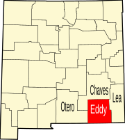
La Huerta, formerly known as Carlsbad North, is an unincorporated area and census-designated place (CDP) in Eddy County, New Mexico, United States. The population was 1,246 at the 2010 census. [4] The community, whose name means "fruit garden" in Spanish, was named after the orchards and garden plots that supplied food to Carlsbad. [5]
La Huerta is located in central Eddy County and is bordered to the south by the city of Carlsbad, the county seat. The Pecos River flows past 3/4 mile to the south. [2]
According to the United States Census Bureau, the CDP has a total area of 1.5 square miles (4.0 km2), all land. [4]
Census | Pop. | Note | %± |
---|---|---|---|
2020 | 1,448 | — | |
U.S. Decennial Census [6] [3] |
As of the census [7] of 2000, there were 1,245 people, 484 households, and 377 families residing in the CDP. The population density was 851.1 people per square mile (329.2/km2). There were 526 housing units at an average density of 359.6 per square mile (139.1/km2). The racial makeup of the CDP was 92.61% White, 0.32% African American, 0.32% Native American, 0.80% Asian, 0.40% Pacific Islander, 4.58% from other races, and 0.96% from two or more races. Hispanic or Latino of any race were 14.54% of the population.
There were 484 households, out of which 31.2% had children under the age of 18 living with them, 69.4% were married couples living together, 5.4% had a female householder with no husband present, and 22.1% were non-families. 20.5% of all households were made up of individuals, and 8.3% had someone living alone who was 65 years of age or older. The average household size was 2.57 and the average family size was 2.97.
In the CDP, the population was spread out, with 26.3% under the age of 18, 5.2% from 18 to 24, 21.4% from 25 to 44, 31.0% from 45 to 64, and 16.0% who were 65 years of age or older. The median age was 44 years. For every 100 females, there were 100.2 males. For every 100 females age 18 and over, there were 100.7 males.
The median income for a household in the CDP was $52,361, and the median income for a family was $69,135. Males had a median income of $51,250 versus $28,125 for females. The per capita income for the CDP was $27,192. About 2.9% of families and 3.6% of the population were below the poverty line, including 1.9% of those under age 18 and none of those age 65 or over.
It is within the Carlsbad Municipal School District, [8] which operates Carlsbad High School.
Eddy County is a county located in the U.S. state of New Mexico. As of the 2010 census, the population was 53,829. Its county seat and largest city is Carlsbad. The county was created in 1891 and later organized in 1892. It is north of the Texas state line.
Rough Rock is a census-designated place (CDP) in Apache County, Arizona, United States. The population was 414 at the 2010 census.
East Sahuarita was a census-designated place (CDP) in Pima County, Arizona, United States. The population was 1,419 at the 2000 census. The CDP comprises the unincorporated neighborhoods east of incorporated Sahuarita.
Port LaBelle is a census-designated place (CDP) in Hendry and Glades counties, Florida, United States. The population was 3,530 at the 2010 census, up from 3,050 at the 2000 census.
Goodings Grove was a census-designated place in northern Will County, Illinois, United States. The population was 17,084 at the 2000 census. It is now a neighborhood of the village of Homer Glen, Illinois, which was incorporated in 2001.
Buckner is a census-designated place (CDP) in Oldham County, Kentucky, United States. The population was 4,000 at the 2000 census.
Robinwood is a census-designated place (CDP) in Washington County, Maryland, United States. The population was 4,731 at the 2000 census. It is a part of the Hagerstown Metropolitan Area. Robinwood is home to Hagerstown Community College.
Holiday City South is an unincorporated community and census-designated place (CDP) located within Berkeley Township, in Ocean County, New Jersey, United States. As of the 2010 United States Census, the CDP's population was 3,689.
Loving is a village in Eddy County, New Mexico. As of the 2010 census, the village population was 1,413. Loving was settled by Swiss immigrants in the 1890s.
La Luz is a census-designated place (CDP) in Otero County, New Mexico, United States. The population was 1,615 at the 2000 census. It is located immediately north of Alamogordo and lies in the eastern edge of the Tularosa Basin and on the western flank of the Sacramento Mountains. Until 1848, La Luz was a part of Mexico. The CDP gets its name from the Spanish word for "light."
Algodones is a census-designated place (CDP) in Sandoval County, New Mexico, United States. The population was 814 at the 2010 census. It is part of the Albuquerque Metropolitan Statistical Area.
La Jara is a census-designated place (CDP) in Sandoval County, New Mexico, United States. The population was 209 at the 2000 census. It is part of the Albuquerque Metropolitan Statistical Area.
Cañada de los Alamos is a census-designated place (CDP) in Santa Fe County, New Mexico, United States. It is part of the Santa Fe, New Mexico Metropolitan Statistical Area. The population was 434 at the 2010 census.
La Puebla is a census-designated place (CDP) in Santa Fe County, New Mexico, United States. It is part of the Santa Fe, New Mexico Metropolitan Statistical Area. The population was 1,296 at the 2000 census.
Ingold is a census-designated place (CDP) in Sampson County, North Carolina, United States. The population was 484 at the 2000 census.
Glide is a census-designated place (CDP) in Douglas County, Oregon, United States. The population was 1,795 at the 2010 census.
Englewood is a census-designated place (CDP) in Schuylkill County, Pennsylvania, United States. The population was 484 at the 2000 census.
Salisbury is a census-designated place (CDP) in the town of Salisbury in Essex County, Massachusetts, United States. The population was 4,869 at the 2010 census.
Hebron is a census-designated place (CDP) in the town of Hebron, Jefferson County, Wisconsin, United States. The population was 209 at the 2020 census. It is located on the Bark River.
Skowhegan is a census-designated place (CDP) in the town of Skowhegan in Somerset County, Maine, in the United States. The population was 6,696 at the 2000 census.