Hope, New Mexico

Last updated • 2 min readFrom Wikipedia, The Free Encyclopedia

Hope, New Mexico
Eddy County New Mexico Incorporated and Unincorporated areas Hope Highlighted.svg
Location of Hope, New Mexico
Usa edcp location map.svg
Red pog.svg
Hope, New Mexico
Location in the United States
Coordinates: 32°48′57″N104°44′09″W / 32.81583°N 104.73583°W / 32.81583; -104.73583
CountryUnited States
State New Mexico
County Eddy
Area
[1]
  Total1.22 sq mi (3.17 km2)
  Land1.22 sq mi (3.17 km2)
  Water0.00 sq mi (0.00 km2)
Elevation
[2]
4,095 ft (1,248 m)
Population
 (2020) [3]
  Total113
  Density92.40/sq mi (35.66/km2)
Time zone UTC-7 (Mountain (MST))
  Summer (DST) UTC-6 (MDT)
ZIP code
88250
Area code 575
FIPS code 35-33290
GNIS feature ID2413559 [2]

Hope is a village in Eddy County, New Mexico, United States. It is located approximately 20 miles (32 km) west of Artesia on U.S. Route 82. It has had a post office since 1890. [4] As of the 2010 census, the village's population was 105. [5]

Contents

Geography

Hope is located in northwestern Eddy County at 32°48′43″N104°44′01″W / 32.811916°N 104.733565°W / 32.811916; -104.733565 . [6] US 82 passes through the center of the village, leading east 20 miles (32 km) to Artesia and west 90 miles (140 km) over the Sacramento Mountains to Alamogordo.

According to the United States Census Bureau, the village has a total area of 1.22 square miles (3.17 km2), all land. [5]

Climate

Climate data for Hope, New Mexico (1991–2020 normals, extremes 1919–1946, 1966–1995, 2000–present)
MonthJanFebMarAprMayJunJulAugSepOctNovDecYear
Record high °F (°C)81
(27)
87
(31)
92
(33)
100
(38)
109
(43)
115
(46)
111
(44)
106
(41)
104
(40)
97
(36)
88
(31)
81
(27)
115
(46)
Mean daily maximum °F (°C)56.5
(13.6)
60.5
(15.8)
68.2
(20.1)
76.6
(24.8)
85.1
(29.5)
93.9
(34.4)
93.1
(33.9)
91.6
(33.1)
85.5
(29.7)
76.7
(24.8)
65.1
(18.4)
56.7
(13.7)
75.8
(24.3)
Daily mean °F (°C)43.2
(6.2)
46.5
(8.1)
53.6
(12.0)
61.4
(16.3)
70.1
(21.2)
78.4
(25.8)
80.2
(26.8)
79.3
(26.3)
72.5
(22.5)
62.8
(17.1)
51.5
(10.8)
43.7
(6.5)
61.9
(16.6)
Mean daily minimum °F (°C)29.9
(−1.2)
32.5
(0.3)
38.9
(3.8)
46.1
(7.8)
55.1
(12.8)
63.0
(17.2)
67.4
(19.7)
67.0
(19.4)
59.5
(15.3)
49.0
(9.4)
38.0
(3.3)
30.7
(−0.7)
48.1
(8.9)
Record low °F (°C)−5
(−21)
−5
(−21)
2
(−17)
15
(−9)
28
(−2)
41
(5)
48
(9)
48
(9)
35
(2)
13
(−11)
−4
(−20)
−10
(−23)
−10
(−23)
Average precipitation inches (mm)0.41
(10)
0.36
(9.1)
0.55
(14)
0.58
(15)
1.03
(26)
0.89
(23)
1.97
(50)
1.88
(48)
2.82
(72)
1.13
(29)
0.67
(17)
0.57
(14)
12.86
(327)
Average snowfall inches (cm)0.5
(1.3)
0.7
(1.8)
0.1
(0.25)
0.0
(0.0)
0.0
(0.0)
0.0
(0.0)
0.0
(0.0)
0.0
(0.0)
0.0
(0.0)
0.1
(0.25)
0.3
(0.76)
1.7
(4.3)
3.4
(8.6)
Average precipitation days (≥ 0.01 in)2.52.62.32.13.73.65.97.16.34.32.63.046.0
Average snowy days (≥ 0.1 in)0.40.30.10.00.00.00.00.00.00.00.30.61.7
Source: NOAA [7] [8]

History

Founded in 1884 as "Badgerville", the name was changed in 1890 for post office purposes. [4]

The town was featured in Life magazine on May 29, 1950, with an account of the newly elected Petticoat City Government under Mayor Ethel Altman. [9]

Demographics

Historical population
CensusPop.Note
1910 417
1920 4303.1%
1930 275−36.0%
1940 2895.1%
1950 186−35.6%
1960 108−41.9%
1970 90−16.7%
1980 11123.3%
1990 101−9.0%
2000 1075.9%
2010 105−1.9%
2020 1137.6%
U.S. Decennial Census [10] [3]

As of the census [11] of 2000, there were 107 people, 45 households, and 27 families residing in the village. The population density was 92.3 inhabitants per square mile (35.6/km2). There were 58 housing units at an average density of 50.0 per square mile (19.3/km2). The racial makeup of the village was 77.57% White, 0.93% African American, 4.67% from other races, and 16.82% from two or more races. Hispanic or Latino of any race were 16.82% of the population.

There were 45 households, out of which 26.7% had children under the age of 18 living with them, 48.9% were married couples living together, 11.1% had a female householder with no husband present, and 40.0% were non-families. 31.1% of all households were made up of individuals, and 26.7% had someone living alone who was 65 years of age or older. The average household size was 2.38 and the average family size was 3.00.

In the village, the population was spread out, with 25.2% under the age of 18, 6.5% from 18 to 24, 22.4% from 25 to 44, 18.7% from 45 to 64, and 27.1% who were 65 years of age or older. The median age was 42 years. For every 100 females, there were 109.8 males. For every 100 females age 18 and over, there were 105.1 males.

The median income for a household in the village was $17,639, and the median income for a family was $28,750. Males had a median income of $19,583 versus $43,750 for females. The per capita income for the village was $12,867. There were 10.7% of families and 20.2% of the population living below the poverty line, including no under eighteens and 7.9% of those over 64.

Education

It is within the Artesia Public Schools school district. [12] The K-8 school Peñasco Elementary School is west of Hope, and serves the Hope community. [13] Artesia Park Junior High School is the district's sole school for grade 9, and Artesia High School is the school district's sole comprehensive high school, for grades 10-12. [14]

Related Research Articles

<span class="mw-page-title-main">Rio Arriba County, New Mexico</span> County in New Mexico, United States

Rio Arriba County is a county in the U.S. state of New Mexico. As of the 2020 census, the population was 40,363. Its county seat is Tierra Amarilla. Its northern border is the Colorado state line.

<span class="mw-page-title-main">Luna County, New Mexico</span> County in New Mexico, United States

Luna County(Spanish: Condado de Luna) is a county located in the U.S. state of New Mexico. As of the 2020 census, the population was 25,427. Its county seat is Deming. This county abuts the Mexican border. Luna County comprises the Deming, NM Micropolitan Statistical Area.

<span class="mw-page-title-main">Lea County, New Mexico</span> County in New Mexico, United States

Lea County is a county located in the U.S. state of New Mexico. As of the 2020 census, its population was 74,455.

<span class="mw-page-title-main">Eddy County, New Mexico</span> County in New Mexico, United States

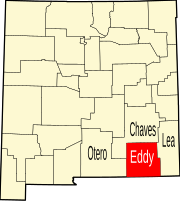
Eddy County is a county located in the U.S. state of New Mexico. As of the 2020 census, the population was 62,314. Its county seat and largest city is Carlsbad. The county was created in 1891 and later organized in 1892. It is north of the Texas state line.

<span class="mw-page-title-main">Chaves County, New Mexico</span> County in New Mexico, United States

Chaves County is a county in New Mexico, United States. As of the 2020 census, the population was 65,157. Its county seat is Roswell. Chaves County was named for Colonel Jose Francisco Chaves, a military leader there during the Civil War and later in Navajo campaigns. The county was created by the New Mexico Territorial Legislature on February 25, 1889, out of land from Lincoln County.

<span class="mw-page-title-main">Hagerman, New Mexico</span> Town in New Mexico, United States

Hagerman is a town in Chaves County, New Mexico, United States. The population was 1,251 at the 2010 census.

<span class="mw-page-title-main">Rincon, New Mexico</span> CDP in New Mexico, United States

Rincon is a census-designated place (CDP) in Doña Ana County, New Mexico, United States. As of the 2010 census, the CDP population was 271. It is part of the Las Cruces Metropolitan Statistical Area.

<span class="mw-page-title-main">University Park, New Mexico</span> Census-designated place in New Mexico, United States

University Park is a census-designated place (CDP) in Doña Ana County, New Mexico, United States. The population was 4,192 at the 2010 census. It is part of the Las Cruces Metropolitan Statistical Area.

<span class="mw-page-title-main">Artesia, New Mexico</span> City in New Mexico, United States

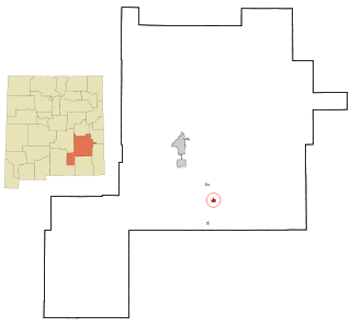
Artesia is a city in Eddy County, New Mexico, centered at the intersection of U.S. routes 82 and 285; the two highways serve as the city's Main Street and First Street, respectively. As of the 2020 census, the city population was 12,875.

<span class="mw-page-title-main">Lovington, New Mexico</span> City in New Mexico, United States

Lovington is a city in, and the county seat of, Lea County, New Mexico, United States. The population was 11,009 at the 2010 census, up from 9,471 in 2000.

<span class="mw-page-title-main">Cloudcroft, New Mexico</span> Village in Otero County, New Mexico, United States

Cloudcroft is a village in Otero County, New Mexico, United States, and is located within the Lincoln National Forest. The population was 750 at the 2020 census.

<span class="mw-page-title-main">La Luz, New Mexico</span> CDP in New Mexico, United States

La Luz is a census-designated place (CDP) in Otero County, New Mexico, United States. The population was 1,615 at the 2000 census. It is located immediately north of Alamogordo and lies in the eastern edge of the Tularosa Basin and on the western flank of the Sacramento Mountains. Until 1848, La Luz was a part of Mexico. The CDP gets its name from the Spanish word for "light."

<span class="mw-page-title-main">Cuba, New Mexico</span> Village in Sandoval County, New Mexico, United States

Cuba is a village in Sandoval County, New Mexico, United States. As of the 2010 census, the village population was 735. It is part of the Albuquerque Metropolitan Statistical Area.

<span class="mw-page-title-main">Jemez Springs, New Mexico</span> Village in Sandoval County, New Mexico, United States

Jemez Springs is a village in Sandoval County, New Mexico, United States. The population was 250 at the 2010 census. Named for the nearby Pueblo of Jemez, the village is the site of Jemez State Monument and the headquarters of the Jemez Ranger District. The village and nearby locations in the Jemez Valley are the site of hot springs and several religious retreats.

<span class="mw-page-title-main">Cundiyo, New Mexico</span> CDP in New Mexico, United States

Cundiyo is a census-designated place (CDP) in Santa Fe County, New Mexico, United States. It is part of the Santa Fe, New Mexico Metropolitan Statistical Area. The population was 72 at the 2010 census. The name means round hill of the little bells in Tewa.

<span class="mw-page-title-main">Chamisal, New Mexico</span> Census-designated place in Taos County, New Mexico, United States

Chamisal is a census-designated place (CDP) in Taos County, New Mexico. It is located along the scenic High Road to Taos. The population was 301 at the time of the 2000 census.

<span class="mw-page-title-main">Picuris Pueblo, New Mexico</span> CDP in New Mexico, United States

Picuris Pueblo is a historic pueblo in Taos County, New Mexico, United States. It is also a census-designated place (CDP) and a federally recognized tribe of Native American Pueblo people. The 2010 census estimated that 68 people lived in the CDP, while 267 people in the U.S. reported being of the tribal group Picuris alone and 439 reported being of the tribal group Picuris alone or in combination with other groups. Picurís Pueblo is a member of the Eight Northern Pueblos. Their own name for their pueblo is P'įwweltha, meaning "mountain warrior place" or "mountain pass place." They speak the Picuris dialect of the Northern Tiwa language, part of the Kiowa-Tanoan language family.

<span class="mw-page-title-main">Rio Lucio, New Mexico</span> CDP in New Mexico, United States

Rio Lucio is a census-designated place (CDP) in Taos County, New Mexico, United States. The population was 379 at the 2000 census.

<span class="mw-page-title-main">Vadito, New Mexico</span> CDP in New Mexico, United States

Vadito is a census-designated place (CDP) in southern Taos County, New Mexico, United States. It is on the scenic High Road to Taos. The population was 270 at the 2010 census.

<span class="mw-page-title-main">Peñasco, New Mexico</span> CDP in New Mexico, United States

Peñasco is a census-designated place (CDP) in Taos County, New Mexico. It is located along the scenic High Road to Taos. The population is estimated at 1,200 (2015).

References

  1. "ArcGIS REST Services Directory". United States Census Bureau. Retrieved October 12, 2022.
  2. 1 2 U.S. Geological Survey Geographic Names Information System: Hope, New Mexico
  3. 1 2 "Census Population API". United States Census Bureau. Retrieved October 12, 2022.
  4. 1 2 Julyan, Robert (1998), "Hope". Place Names of New Mexico (2nd edition), University of New Mexico Press, Albuquerque, New Mexico, page 169, ISBN   0-8263-1689-1
  5. 1 2 "Geographic Identifiers: 2010 Demographic Profile Data (G001): Hope village, New Mexico". U.S. Census Bureau, American Factfinder. Retrieved February 17, 2016.[ dead link ]
  6. "US Gazetteer files: 2010, 2000, and 1990". United States Census Bureau. February 12, 2011. Retrieved April 23, 2011.
  7. "NOWData - NOAA Online Weather Data". National Oceanic and Atmospheric Administration. Retrieved January 1, 2024.
  8. "Summary of Monthly Normals 1991-2020". National Oceanic and Atmospheric Administration. Retrieved January 1, 2024.
  9. LIFE. Time Inc. ISSN   0024-3019 . Retrieved December 6, 2014.
  10. "Census of Population and Housing". Census.gov. Retrieved June 4, 2015.
  11. "U.S. Census website". United States Census Bureau . Retrieved January 31, 2008.
  12. "2020 CENSUS - SCHOOL DISTRICT REFERENCE MAP: Eddy County, NM" (PDF). U.S. Census Bureau . Retrieved June 28, 2022. - Text list
  13. "Home". Peñasco Elementary School. Retrieved July 13, 2022. [...]we serve students in kindergarten through the 8th grade in and around Hope.[...]12 Dunken St. Hope, NM 88250 - Not in the Hope city limits - Google Maps lists the school at "12 Pinon Dunken Rd, Hope, NM 88250"
  14. "Our Schools". Artesia Public Schools . Retrieved June 28, 2022. 12 Dunken St. Hope, NM 88250