Catron County is a county in the U.S. state of New Mexico. As of the 2010 census, the population was 3,725, making it New Mexico's third-least populous county. Its county seat is Reserve. Catron County is New Mexico's largest county by area.

Guadalupe Mountains National Park is an American national park in the Guadalupe Mountains, east of El Paso, Texas. The mountain range includes Guadalupe Peak, the highest point in Texas at 8,749 feet (2,667 m), and El Capitan used as a landmark by travelers on the route later followed by the Butterfield Overland Mail stagecoach line. The ruins of a stagecoach station stand near the Pine Springs visitor center. The restored Frijole Ranch contains a small museum of local history and is the trailhead for Smith Spring. The park covers 86,367 acres in the same mountain range as Carlsbad Caverns National Park, about 25 miles (40 km) to the north in New Mexico. The Guadalupe Peak Trail winds through pinyon pine and Douglas-fir forests as it ascends over 3,000 feet (910 m) to the summit of Guadalupe Peak, with views of El Capitan and the Chihuahuan Desert.
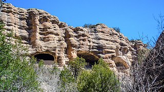
Gila Cliff Dwellings National Monument is a U.S. National Monument created to protect Mogollon cliff dwellings in the Gila Wilderness on the headwaters of the Gila River in southwest New Mexico. The 533-acre (2.16 km2) national monument was established by President Theodore Roosevelt through executive proclamation on November 16, 1907. It is located in the extreme southern portion of Catron County. Visitors can access the Monument by traveling northbound from Silver City, New Mexico approximately 37 miles on NM 15.

Mescalero or Mescalero Apache is an Apache tribe of Southern Athabaskan Native Americans. The tribe is federally recognized as the Mescalero Apache Tribe of the Mescalero Apache Reservation, located in south-central New Mexico.

Mogollon culture is an archaeological culture of Native American peoples from Southern New Mexico and Arizona, Northern Sonora and Chihuahua, and Western Texas. The northern part of this region is Oasisamerica, while the southern span of the Mogollon culture is known as Aridoamerica.
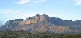
The Guadalupe Mountains are a mountain range located in West Texas and southeastern New Mexico. The range includes the highest summit in Texas, Guadalupe Peak, 8,751 ft (2,667 m), and the "signature peak" of West Texas, El Capitan, both of which are located within Guadalupe Mountains National Park. The Guadalupe Mountains are bordered by the Pecos River valley and Llano Estacado to the east and north, Delaware Mountains to the south, and Sacramento Mountains to the west.

The Sacramento Mountains are a mountain range in the south-central part of the U.S. state of New Mexico, lying just east of Alamogordo in Otero County. From north to south, the Sacramento Mountains extend for 85 miles (137 km), and from east to west they encompass 42 miles (68 km).

Skeleton Canyon, called Cañon Bonita by the Mexicans, is located 30 miles (50 km) northeast of the town of Douglas, Arizona, in the Peloncillo Mountains, which straddle the modern Arizona and New Mexico state line, in the New Mexico Bootheel region.

The Fort Apache Indian Reservation is an Indian reservation in northeastern Arizona, United States, encompassing parts of Navajo, Gila, and Apache counties. It is home to the federally recognized White Mountain Apache Tribe of the Fort Apache Reservation, a Western Apache tribe. It has a land area of 1.6 million acres and a population of 12,429 people as of the 2000 census. The largest community is in Whiteriver.

The following is an alphabetical list of articles related to the U.S. state of Arizona.

Lincoln National Forest is a unit of the U.S. Forest Service located in southern New Mexico. Established by Presidential Proclamation in 1902 as the Lincoln Forest Reserve, the 1,103,897 acres (4,467.31 km2) forest begins near the Texas border and contains lands in parts of Chaves, Eddy, Lincoln, and Otero counties. The three Ranger Districts within the forest contain all or part of four mountain ranges, and include a variety of different environmental areas, from desert to heavily forested mountains and sub-alpine grasslands. Established to balance conservation, resource management, and recreation, the lands of the Lincoln National Forest include important local timber resources, protected wilderness areas, and popular recreation and winter sports areas. The forest headquarters is located in Alamogordo, N.M. with local offices in Carlsbad, Cloudcroft, and Ruidoso.

Gila is a census-designated place in Grant County, New Mexico, United States. It is 48 kilometres (30 mi) northwest of the county seat, Silver City. Its population was 314 as of the 2010 census. The community is located in the irrigated valley of the Gila River in the midst of hilly and mountainous semi-arid terrain. The townsite was sporadically populated by the Apache, Spanish and Mexican colonists, and American Mountain Men prior to the rise to prominence of the million-acre Lyons & Campbell Ranch. The ranch established its headquarters in Gila in 1890 and was one of the largest ranches in the United States. The headquarters building is on the National Register of Historic Places.
Oliver Lee Memorial State Park is a state park of New Mexico, United States, whose two tracts preserve a canyon in the Sacramento Mountains and Oliver Lee's historic 19th-century ranch house. The 640-acre (260 ha) park is located in Otero County at an elevation of 4,363 feet (1,330 m). It is situated at the base of Dog Canyon and provides opportunities for camping, hiking, picnicking, wildlife viewing, a nature trail, and guided tours of the ranch house.

The San Mateo Mountains are a mountain range in Socorro County, in west-central New Mexico in the southwestern United States. The highest point in the range is West Blue Mountain, at 10,336 ft. The range runs roughly north-south and is about 40 miles (64 km) long. It lies about 25 miles (40 km) north-northwest of the town of Truth or Consequences and about 30 miles (48 km) southwest of Socorro. They should not be confused with the identically named range in Cibola and McKinley counties, north of this range.
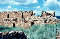
Kinishba Ruins is a 600-room Mogollon great house archaeological site in eastern Arizona and is administered by the White Mountain Apache Tribe. It is located on the present-day Fort Apache Indian Reservation, in the Apache community of Canyon Day. As it demonstrates a combination of both Mogollon and Ancestral Puebloan cultural traits, archaeologists consider it part of the historical lineage of both the Hopi and Zuni cultures. It is designated as a National Historic Landmark.

Polvadera is an unincorporated community and census-designated place in Socorro County in central New Mexico, United States. It is located on the west bank of the Rio Grande, near the mouth of the Rio Salado, and on the western spur of El Camino Real de Tierra Adentro.

McKittrick Canyon is a scenic canyon within the Guadalupe Mountains of West Texas and Eddy County, New Mexico. The steep, towering walls of McKittrick Canyon protect a rich riparian oasis in the midst of the Chihuahuan Desert.

Sitting Bull Falls is a series of waterfalls located in a canyon in the Lincoln National Forest southwest of the city of Carlsbad, New Mexico. The United States Department of Agriculture's Forest Service maintains a popular recreation area for day use at the location of the falls.
Piñon is an unincorporated ranching community in Otero County in southern New Mexico, in the southwestern United States. The town is in the pinon-juniper shrublands habitat with an altitude of 6,060 feet. It is located at the intersection of NM Route 24 and NM Route 506. The postoffice in Piñon opened in 1907. In 2014, Piñon was ranked as the most politically conservative town in New Mexico.

The Apache Campaign of 1896 was the final United States Army operation against Apaches who were raiding and not living in a reservation. It began in April after some Apaches killed three American settlers in Arizona. The Apaches were pursued by the army, which caught up with them in the Four Corners region of Arizona, New Mexico, Sonora and Chihuahua. There were only two important encounters during the campaign and, because both of them occurred in the remote Four Corners region, it is unknown if they took place on American or Mexican soil.