Grant County | |
---|---|
Coordinates: 32°44′N108°23′W / 32.73°N 108.38°W | |
Country | United States |
State | New Mexico |
Founded | 1868 |
Named for | Ulysses S. Grant |
Seat | Silver City |
Largest town | Silver City |
Area | |
• Total | 3,968 sq mi (10,280 km2) |
• Land | 3,962 sq mi (10,260 km2) |
• Water | 5.9 sq mi (15 km2) 0.1% |
Population | |
• Estimate (2021) | 27,889 |
• Density | 7.1/sq mi (2.7/km2) |
Time zone | UTC−7 (Mountain) |
• Summer (DST) | UTC−6 (MDT) |
Congressional district | 2nd |
Website | www |
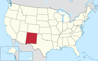
Grant County is a county located in the U.S. state of New Mexico. At the 2020 census, the population was 28,185. [1] Its county seat is Silver City. [2] The county was founded in 1868 and named for Ulysses S. Grant, the 18th President of the United States. [3]
Grant County comprises the Silver City, NM, Micropolitan Statistical Area. It is part of the Southwest New Mexico Council of Governments. [4]
According to the U.S. Census Bureau, the county has a total area of 3,968 square miles (10,280 km2), of which 3,962 square miles (10,260 km2) is land and 5.9 square miles (15 km2) (0.1%) is water. [5]
Census | Pop. | Note | %± |
---|---|---|---|
1870 | 1,143 | — | |
1880 | 4,539 | 297.1% | |
1890 | 9,657 | 112.8% | |
1900 | 12,883 | 33.4% | |
1910 | 14,813 | 15.0% | |
1920 | 21,939 | 48.1% | |
1930 | 19,050 | −13.2% | |
1940 | 20,050 | 5.2% | |
1950 | 21,649 | 8.0% | |
1960 | 18,700 | −13.6% | |
1970 | 22,030 | 17.8% | |
1980 | 26,204 | 18.9% | |
1990 | 27,676 | 5.6% | |
2000 | 31,002 | 12.0% | |
2010 | 29,514 | −4.8% | |
2020 | 28,185 | −4.5% | |
2021 (est.) | 27,889 | [6] | −1.1% |
U.S. Decennial Census [7] 1790-1960 [8] 1900-1990 [9] 1990-2000 [10] 2010-2016 [1] |
At the 2000 census, [11] there were 31,002 people, 12,146 households and 8,514 families living in the county. The population density was 8 people per square mile (3.1 people/km2). There were 14,066 housing units at an average density of 4 units per square mile (1.5/km2). The racial make-up was 75.67% White, 0.52% Black or African American, 1.35% Native American, 0.29% Asian, 0.03% Pacific Islander, 19.02% from other races, and 3.11% from two or more races. 48.79% of the population were Hispanic or Latino of any race.
There were 12,146 households, of which 31.30% had children under the age of 18 living with them, 52.70% were married couples living together, 12.90% had a female householder with no husband present, and 29.90% were non-families. 25.70% of all households were made up of individuals, and 10.70% had someone living alone who was 65 years of age or older. The average household size was 2.50 and the average family size was 3.01.
26.20% of the population were under the age of 18, 8.50% from 18 to 24, 23.70% from 25 to 44, 25.10% from 45 to 64 and 16.50% were 65 years of age or older. The median age was 39 years. For every 100 females there were 95.10 males. For every 100 females age 18 and over, there were 91.30 males.
The median household income was $29,134 and the median family income was $34,231. Males had a median income of $31,126 and females $19,627. The per capita income was $14,597. About 15.10% of families and 18.70% of the population were below the poverty line, including 25.90% of those under age 18 and 9.50% of those age 65 or over.
At the 2010 census, there were 29,514 people, 12,586 households and 7,941 families living in the county. [12] The population density was 7.4 per square mile (2.9/km2). There were 14,693 housing units at an average density of 3.7 per square mile (1.4/km2). [13] The racial make-up was 84.9% white, 1.4% American Indian, 0.9% black or African American, 0.4% Asian, 0.1% Pacific islander, 9.6% from other races and 2.8% from two or more races. Those of Hispanic or Latino origin made up 48.3% of the population. [12] In terms of ancestry, 11.9% were English, 11.8% were German, 10.4% were Irish, and 2.9% were American. [14]
Of the 12,586 households, 26.9% had children under the age of 18 living with them, 45.3% were married couples living together, 12.6% had a female householder with no husband present, 36.9% were non-families, and 30.9% of all households were made up of individuals. The average household size was 2.30 and the average family size was 2.86. The median age was 45.9 years. [12]
The median Household income was $36,591 and the median family income was $44,360. Males had a median income of $38,731 and females $27,161. The per capita income was $21,164. About 11.7% of families and 14.8% of the population were below the poverty line, including 23.8% of those under age 18 and 5.2% of those age 65 or over. [15]
At the 2020 census, [16] there were 28,185 people and 11,496 households in the county. The population density was 7.1 per square mile (2.7/km2). There were 14,584 housing units at an average density of 3.7 per square mile (1.4/km2). The racial make-up was 64.8% white, 2.1% American Indian, 1.1% Black or African American, 0.7% Asian, 0.1% Native Hawaiian or Pacific Islander, 11.7% from other races, and 19.5% of two or more races. 47.8% of the population are of Hispanic origin. [17]
Grant County is heavily Democratic. Since 1932, it has only voted for the Republican presidential nominee twice, both times by narrow margins.
Year | Republican | Democratic | Third party(ies) | |||
---|---|---|---|---|---|---|
No. | % | No. | % | No. | % | |
2024 | 6,580 | 46.39% | 7,301 | 51.47% | 304 | 2.14% |
2020 | 6,553 | 45.40% | 7,590 | 52.58% | 292 | 2.02% |
2016 | 5,288 | 41.28% | 6,276 | 48.99% | 1,247 | 9.73% |
2012 | 5,358 | 41.53% | 7,090 | 54.95% | 454 | 3.52% |
2008 | 5,406 | 39.30% | 8,142 | 59.19% | 207 | 1.50% |
2004 | 6,135 | 45.81% | 7,095 | 52.98% | 162 | 1.21% |
2000 | 4,961 | 44.13% | 5,673 | 50.47% | 607 | 5.40% |
1996 | 3,993 | 36.54% | 5,860 | 53.62% | 1,075 | 9.84% |
1992 | 2,917 | 28.38% | 5,603 | 54.52% | 1,757 | 17.10% |
1988 | 4,196 | 43.10% | 5,443 | 55.91% | 96 | 0.99% |
1984 | 4,979 | 45.93% | 5,755 | 53.09% | 106 | 0.98% |
1980 | 4,628 | 47.41% | 4,600 | 47.13% | 533 | 5.46% |
1976 | 4,095 | 43.90% | 5,176 | 55.49% | 57 | 0.61% |
1972 | 4,431 | 50.46% | 4,081 | 46.48% | 269 | 3.06% |
1968 | 2,908 | 38.52% | 3,817 | 50.56% | 824 | 10.92% |
1964 | 2,042 | 27.92% | 5,253 | 71.82% | 19 | 0.26% |
1960 | 2,468 | 35.93% | 4,378 | 63.74% | 22 | 0.32% |
1956 | 3,224 | 43.70% | 4,122 | 55.88% | 31 | 0.42% |
1952 | 3,421 | 43.18% | 4,315 | 54.47% | 186 | 2.35% |
1948 | 1,999 | 34.90% | 3,592 | 62.72% | 136 | 2.37% |
1944 | 1,970 | 36.17% | 3,472 | 63.75% | 4 | 0.07% |
1940 | 2,015 | 33.98% | 3,914 | 66.00% | 1 | 0.02% |
1936 | 1,469 | 31.02% | 3,215 | 67.88% | 52 | 1.10% |
1932 | 1,381 | 28.80% | 3,344 | 69.74% | 70 | 1.46% |
1928 | 2,058 | 50.69% | 1,994 | 49.11% | 8 | 0.20% |
1924 | 1,756 | 39.59% | 2,085 | 47.00% | 595 | 13.41% |
1920 | 2,230 | 53.77% | 1,879 | 45.31% | 38 | 0.92% |
1916 | 1,869 | 43.73% | 2,305 | 53.93% | 100 | 2.34% |
1912 | 439 | 20.72% | 1,130 | 53.33% | 550 | 25.96% |
Greenlee County is a county in the southeastern part of the U.S. state of Arizona. As of the 2020 census, the population was 9,563, making it Arizona's least populous county. The county seat is Clifton.
Taos County is a county in the U.S. state of New Mexico. As of the 2020 census, the population was 34,489. Its county seat is Taos. The county was formed in 1852 as one of the original nine counties in New Mexico Territory.
Roosevelt County is a county located in the U.S. state of New Mexico. As of the 2020 census, the population was 19,191. Its county seat is Portales. The county was created in 1903 from Chaves and Guadalupe counties and named for the then-current President of the United States, Theodore Roosevelt. The county's eastern border is the Texas state line. Roosevelt County comprises the Portales, NM Micropolitan Statistical Area, which is also included in the Clovis–Portales, NM Combined Statistical Area.
Luna County is a county located in the U.S. state of New Mexico. As of the 2020 census, the population was 25,427. Its county seat is Deming. This county abuts the Mexican border. Luna County comprises the Deming, NM Micropolitan Statistical Area.
Hidalgo County is the southernmost county of the U.S. state of New Mexico. As of the 2020 census, the population was 4,178. The county seat and largest city is Lordsburg. A bill creating Hidalgo from the southern part of Grant County was passed on February 25, 1919, taking effect at the beginning of 1920. The county was named for the town north of Mexico City where the Treaty of Guadalupe Hidalgo was signed, which in turn was named for Miguel Hidalgo y Costilla, the priest who is known as the "Father of Mexican Independence."
Harding County is a county in the U.S. state of New Mexico. As of the 2020 census, the population was 657, making it the least populous county in the state, and the 13th-smallest county by population in the United States. Its county seat is Mosquero. The county is named for United States President Warren G. Harding, and was created on the day of his inauguration as president on March 4, 1921, making him the most recent president to have a county in any state named after him.
Littleton is a town in Aroostook County, Maine, United States. The population was 997 at the 2020 census.
Bagley is a city in Clearwater County, Minnesota, United States. The population was 1,285 at the 2020 census. It is the county seat of Clearwater County.
Oran is a city in Scott County, Missouri, United States. The population was 1,294 at the 2010 census.
Grantwood Village is a town in St. Louis County, Missouri, United States. The population was 863 at the 2010 census.
Grant is a city and county seat of Perkins County, Nebraska, United States. The population was 1,165 at the 2010 census.
Chilili is a census-designated place in Bernalillo County, New Mexico, United States. The population was 137 at the 2010 census. It is part of the Albuquerque Metropolitan Statistical Area.
Acomita Lake is a census-designated place (CDP) in Cibola County, New Mexico, United States. The population was 339 at the 2020 census.
Milan is a village in Cibola County, New Mexico, United States. The population was 3,245 at the 2010 census.
Skyline-Ganipa is a census-designated place (CDP) in Cibola County, New Mexico, United States. The population was 1,224 at the 2010 census.
Bayard is a city in Grant County, New Mexico, United States. It is near Santa Rita, east of Silver City. The population was 2,328 at the 2010 census, down from 2,534 in 2000. This city was incorporated on August 20, 1938.
Hurley is a town in Grant County, New Mexico, United States. The population was 1,297 at the 2010 census, down from 1,464 in 2000.
Bethel is a village in Tate Township, Clermont County, Ohio, United States. The population was 2,620 at the 2020 census.
Milbank is a city in Grant County, South Dakota, United States, located along the South Fork of the Whetstone River. The population was 3,544 at the 2020 census. It is the county seat of Grant County. Milbank is the birthplace of American Legion Baseball. The program was created in Milbank in 1925 and is now enjoyed by high school aged youth on more than five thousand teams in all fifty states.
Dickeyville is a village in Grant County, Wisconsin, United States. The population was 1,061 at the 2010 census.