Hurley, New Mexico

Last updated

Hurley, New Mexico
Nickname: 
Brindley Town
Grant County New Mexico Incorporated and Unincorporated areas Hurley Highlighted.svg
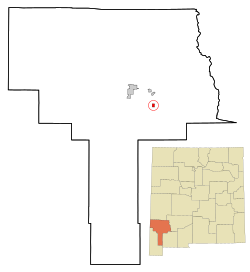
Location of Hurley, New Mexico
Usa edcp location map.svg
Red pog.svg
Hurley, New Mexico
Location in the United States
Coordinates: 32°41′59″N108°7′43″W / 32.69972°N 108.12861°W / 32.69972; -108.12861
Country United States
State New Mexico
County Grant
Area
[1]
  Total1.02 sq mi (2.65 km2)
  Land1.02 sq mi (2.64 km2)
  Water0.00 sq mi (0.01 km2)
Elevation
5,722 ft (1,744 m)
Population
 (2020) [2]
  Total1,256
  Density1,231.37/sq mi (475.35/km2)
Time zone UTC-7 (Mountain (MST))
  Summer (DST) UTC-6 (MDT)
ZIP code
88043
Area code 575
FIPS code 35-33850
GNIS feature ID0920614 [3]
Website www.townofhurley.us

Hurley is a town in Grant County, New Mexico, United States. [3] The population was 1,297 at the 2010 census, [4] down from 1,464 in 2000.

Contents

Geography

Hurley is located in east-central Grant County at 32°41′59″N108°7′43″W / 32.69972°N 108.12861°W / 32.69972; -108.12861 (32.699594, -108.128629). [5] U.S. Route 180 passes through the town, leading north 4 miles (6 km) to Bayard, and southeast 38 miles (61 km) to Deming and Interstate 10.

The Grant County Airport and the hamlet and ranch of Apache Tejo are approximately three miles south of Hurley.

The large, open pit Chino Mine and its related facilities lie just to the east of Hurley.

According to the United States Census Bureau, the town has a total area of 1.02 square miles (2.65 km2), of which 0.004 square miles (0.01 km2), or 0.36%, is water. [4]

Demographics

Historical population
CensusPop.Note
1950 2,079
1960 1,851−11.0%
1970 1,796−3.0%
1980 1,616−10.0%
1990 1,534−5.1%
2000 1,464−4.6%
2010 1,297−11.4%
2020 1,256−3.2%
U.S. Decennial Census [6] [2]

As of the census [7] of 2000, there were 1,464 people, 563 households, and 407 families residing in the town. The population density was 1,433.0 inhabitants per square mile (553.3/km2). There were 650 housing units at an average density of 636.2 per square mile (245.6/km2). The racial makeup of the town was 71.79% White, 0.14% African American, 2.05% Native American, 0.07% Asian, 23.43% from other races, and 2.53% from two or more races. Hispanic or Latino of any race were 60.31% of the population.

There were 563 households, out of which 29.5% had children under the age of 18 living with them, 53.1% were married couples living together, 13.9% had a female householder with no husband present, and 27.7% were non-families. 23.8% of all households were made up of individuals, and 13.0% had someone living alone who was 65 years of age or older. The average household size was 2.60 and the average family size was 3.08.

In the town, the population was spread out, with 26.5% under the age of 18, 8.2% from 18 to 24, 22.0% from 25 to 44, 24.2% from 45 to 64, and 19.1% who were 65 years of age or older. The median age was 38 years. For every 100 females, there were 92.1 males. For every 100 females age 18 and over, there were 85.2 males.

The median income for a household in the town was $27,404, and the median income for a family was $31,181. Males had a median income of $29,667 versus $16,528 for females. The per capita income for the town was $11,999. About 14.4% of families and 15.6% of the population were below the poverty line, including 23.4% of those under age 18 and 8.8% of those age 65 or over.

Scenes from the action Western film The Lone Ranger were filmed in locations around Hurley. [8]

See also

Related Research Articles

<span class="mw-page-title-main">Grant County, New Mexico</span> County in New Mexico, United States

Grant County is a county located in the U.S. state of New Mexico. At the 2020 census, the population was 28,185. Its county seat is Silver City. The county was founded in 1868 and named for Ulysses S. Grant, the 18th President of the United States.

<span class="mw-page-title-main">Kite, Georgia</span> City in Georgia, United States

Kite is a city in Johnson County, Georgia, United States, along the Little Ohoopee River. The population was 241 at the 2010 census. Kite is part of the Dublin Micropolitan Statistical Area.

<span class="mw-page-title-main">Little York, Indiana</span> Town in Indiana, United States

Little York is a town in Gibson Township, Washington County, in the U.S. state of Indiana. The population was 192 at the 2010 census.

<span class="mw-page-title-main">Rudd, Iowa</span> City in Iowa, United States

Rudd is a city in Floyd County, Iowa, United States. The population was 358 at the time of the 2020 census, a decline of 16.9% from 431 in 2000.

<span class="mw-page-title-main">Stockholm, Maine</span> Town in the state of Maine, United States

Stockholm is a town in Aroostook County, Maine, United States. The population was 250 at the 2020 census.

<span class="mw-page-title-main">Bayard, New Mexico</span> City in New Mexico, United States

Bayard is a city in Grant County, New Mexico, United States. It is near Santa Rita, east of Silver City. The population was 2,328 at the 2010 census, down from 2,534 in 2000. This city was incorporated on August 20, 1938.

<span class="mw-page-title-main">Santa Clara, New Mexico</span> Village in New Mexico, United States

Santa Clara is a village in Grant County, New Mexico, United States. The population was 1,686 at the 2010 census, down from 1,944 in 2000. Today it is a bedroom community for nearby Silver City.

<span class="mw-page-title-main">Montpelier, North Dakota</span> City in North Dakota, United States

Montpelier is a city in Stutsman County, North Dakota, United States. The population was 85 at the 2020 census. Montpelier was founded in 1885.

<span class="mw-page-title-main">Oil Creek Township, Crawford County, Pennsylvania</span> Township of Titusville Pennsylvania in the United States

Oil Creek Township is a township in Crawford County, Pennsylvania, United States. The population was 1,708 at the 2020 census, a decrease from 1,877 at the 2010 census.

<span class="mw-page-title-main">Sparta Township, Crawford County, Pennsylvania</span> Township in Pennsylvania, United States

Sparta Township is a township in Crawford County, Pennsylvania, United States. The population was 1,917 at the 2020 census, up from 1,832 at the 2010 census.

<span class="mw-page-title-main">Wiconisco Township, Dauphin County, Pennsylvania</span> Township in Pennsylvania, United States

Wiconisco Township is a township in Dauphin County, Pennsylvania, United States. The population was 1,162 in the 2020 census. Wiconisco Township took its name from Wiconisco Creek, a west-flowing tributary of the Susquehanna River.

<span class="mw-page-title-main">Oliver Township, Mifflin County, Pennsylvania</span> Township in Pennsylvania, United States

Oliver Township is a township in Mifflin County, Pennsylvania, United States. The population was 2,066 at the time of the 2020 census.

<span class="mw-page-title-main">South Huntingdon Township, Westmoreland County, Pennsylvania</span> Township in Pennsylvania, United States

South Huntingdon Township is a township in Westmoreland County, Pennsylvania, United States. The population was 5,412 at the 2020 census.

<span class="mw-page-title-main">Florence, South Dakota</span> Town in South Dakota, United States

Florence is a town in northwestern Codington County, South Dakota, United States. It is part of the Watertown, South Dakota Micropolitan Statistical Area. The population was 337 at the 2020 census.

<span class="mw-page-title-main">Flemington, West Virginia</span> Town in West Virginia, United States

Flemington is a town in Taylor County, West Virginia, United States. The population was 311 at the 2020 census. Flemington was incorporated in 1922 by the West Virginia Circuit Court, and named for James Fleming, an early settler in the area originally from Hampshire County.

<span class="mw-page-title-main">Downing, Wisconsin</span> Village in Wisconsin, United States

Downing is a village in Dunn County, Wisconsin, United States. Bordering St. Croix County to the west, the village is otherwise surrounded by the Town of Tiffany. The population was 234 at the 2020 census.

<span class="mw-page-title-main">How, Wisconsin</span> Town in Wisconsin, United States

How is a town in Oconto County, Wisconsin, United States. The population was 563 at the 2000 census. The unincorporated community of Hayes is located in the town. The town is named for Calvin F. How, Jr., an insurance and banking executive.

<span class="mw-page-title-main">Deaver, Wyoming</span> Town in Wyoming, United States

Deaver is a town in Big Horn County, Wyoming, United States. The population was 178 at the 2010 census.

Johnstown is a census-designated place (CDP) in Fremont County, Wyoming, United States. The population was 242 at the 2010 census.

<span class="mw-page-title-main">Iola, Wisconsin</span> Village in Wisconsin, United States

Iola is a village in Waupaca County, Wisconsin, United States. The population was 1,236 at the 2020 census. The village is bordered by the towns of Iola and Scandinavia. The community was named after a Potawatomi girl.

References

  1. "ArcGIS REST Services Directory". United States Census Bureau. Retrieved October 12, 2022.
  2. 1 2 "Census Population API". United States Census Bureau. Retrieved October 12, 2022.
  3. 1 2 U.S. Geological Survey Geographic Names Information System: Town of Hurley
  4. 1 2 "Geographic Identifiers: 2010 Demographic Profile Data (G001): Hurley town, New Mexico". American Factfinder. U.S. Census Bureau. Retrieved December 23, 2016.[ dead link ]
  5. "US Gazetteer files: 2010, 2000, and 1990". United States Census Bureau. February 12, 2011. Retrieved April 23, 2011.
  6. "Census of Population and Housing". Census.gov. Retrieved June 4, 2015.
  7. "U.S. Census website". United States Census Bureau . Retrieved January 31, 2008.
  8. "The Lone Ranger (2013) - IMDb".

Commons-logo.svg Media related to Hurley, New Mexico at Wikimedia Commons