Sangre de Cristo Mountains

Last updated
Sangre de Cristo Mountains
MtBlancaEast.jpg
Blanca Peak
Highest point
Peak Blanca Peak,East of Alamosa, Colorado
Elevation 14,351 ft (4,374 m)
Listing Mountain ranges of Colorado
Coordinates 37°34′39″N105°29′08″W / 37.57750°N 105.48556°W / 37.57750; -105.48556
Dimensions
Length242 mi (389 km)north-south
Width120 mi (190 km)east-west
Area17,193 sq mi (44,530 km2)
Naming
Etymology Sangre de Cristo (Spanish: Blood of Christ)
Geography
Country United States
States Colorado and New Mexico
Parent range Rocky Mountains

The Sangre de Cristo Mountains (Spanish for "Blood of Christ") are the southernmost subrange of the Rocky Mountains. They are located in southern Colorado and northern New Mexico in the United States. The mountains run from Poncha Pass in South-Central Colorado, trending southeast and south, ending at Glorieta Pass, southeast of Santa Fe, New Mexico. The mountains contain a number of fourteen thousand foot peaks in the Colorado portion, as well as several peaks in New Mexico which are over thirteen thousand feet.

Contents

The name of the mountains may refer to the occasional reddish hues observed during sunrise and sunset, and when alpenglow occurs, especially when the mountains are covered with snow. Although the particular origin of the name is unclear, it has been in use since the early 19th century. Before that time the terms "La Sierra Nevada", "La Sierra Madre", "La Sierra", and "The Snowies" (used by English speakers) were used. [1] According to legend, "sangre de Cristo" were the last words of a priest who was killed by Native Americans. [2]

Land management and recreation overview

Sangre de Cristo Mountains to the East of Santa Fe, taken during a winter sunset after a snowfall on 29 January 2013 Sangre de Christo Mountains-Winter sunset.jpg
Sangre de Cristo Mountains to the East of Santa Fe, taken during a winter sunset after a snowfall on 29 January 2013
Sangre de Cristo Mountain Range SangreDeCristo.png
Sangre de Cristo Mountain Range
Oblique air photo of northern Sangre de Cristo Range, looking south with Great Sand Dunes near central horizon Sangre de Cristo Range Oct2020.jpg
Oblique air photo of northern Sangre de Cristo Range, looking south with Great Sand Dunes near central horizon
February 2003 astronaut photography of the Sangre de Cristo Mountains from Santa Fe (bottom center) to north of Taos, taken from the International Space Station. Santa Fe Baldy peak at lower right. Valley of the Rio Grande, including the Rio Grande Gorge, west of the mountains. Santa Fe from space.jpg
February 2003 astronaut photography of the Sangre de Cristo Mountains from Santa Fe (bottom center) to north of Taos, taken from the International Space Station. Santa Fe Baldy peak at lower right. Valley of the Rio Grande, including the Rio Grande Gorge, west of the mountains.

Much of the mountains are within various National Forests: the Rio Grande and San Isabel in Colorado, and the Carson and Santa Fe in New Mexico. These publicly accessible areas are managed by the United States Forest Service and are popular for hunting, camping, hiking, mountain biking, backpacking, climbing, and cross-country and downhill skiing.

The mountains include two large wilderness areas, the Sangre de Cristo Wilderness in Colorado and the Pecos Wilderness in New Mexico, as well as some smaller wilderness areas, such as Latir Peak Wilderness. The Great Sand Dunes National Park and Preserve lies on the southwest side of the mountains in Colorado and are managed by the National Park Service.

Subranges

The Sangre de Cristo Mountains are divided into various subranges, described here from north to south. Use of the terms "Sangre de Cristo Range" and "Sangre de Cristo Mountains" is inconsistent and may refer to the northernmost subrange, the southernmost subrange, or the mountains as a whole.[ citation needed ]

Sangre de Cristo Range

The Sangre de Cristo Range, the largest and most northerly subrange of the Sangre de Cristo Mountains, runs directly along the east side of the Rio Grande rift, extending southeast from Poncha Pass for about 75 miles (120 km) through south-central Colorado to La Veta Pass, approximately 20 miles (32 km) west of Walsenburg. They form a high ridge separating the San Luis Valley on the west from the watershed of the Arkansas River on the east.

Crestones

The Crestones are a group of four 14,000+ foot (4,268+ m) peaks (fourteeners) in the Sangre de Cristo Range above Crestone, Colorado.

Spanish Peaks

The Spanish Peaks are a pair of mountains, West Spanish Peak, 13,626 ft (4,153 m), and East Spanish Peak, 12,860 ft (3,920 m), located in southwestern Huerfano County, Colorado. [3] The Spanish Peaks were designated a National Natural Landmark in 1976 as one of the best known examples of igneous dikes. [4] The mountains can be seen from as far as 133 mi (214 km) to the north from Colorado Springs, 65 mi (105 km) to the south from Raton, New Mexico, and 85 mi (137 km) to the east from La Junta, Colorado.

Culebra Range

The Culebra Range runs almost due north and south, with its northern limit at La Veta Pass in Colorado, and its southern limit at Costilla Creek, just south of Big Costilla Peak in New Mexico. Its highest point is Culebra Peak at 14,047 ft (4,282 m), which is notable for being the only fourteener in Colorado on private land with an access fee. Climbers wishing to ascend Culebra must pay a fee (currently US$150 per person), [5] and the number of climbers per year is limited. [6] It is also the most southerly fourteener in the U.S. Rockies. Standing to the east of the main crest are the two prominent Spanish Peaks (West: 13,626 ft (4,153 m), East: 12,860 ft (3,920 m)). These peaks were important landmarks for 19th century travelers on the mountain branch of the Santa Fe Trail.

The western slope of the Culebras and the San Luis Valley are located within the Sangre de Cristo Land Grant, dating back to the 1840s but still a factor in the pattern of land ownership within the grant. The San Luis Valley is arid. The town of San Luis, Colorado has an annual precipitation of only 9.6 inches (240 mm).The surrounding area, traversed by Culebra Creek, has a rich agricultural history and has been the scene of land disputes between the descendants of Hispanic settlers and Anglo ranchers since the 1860s. [7]

Taos Mountains

The Taos Mountains span the western lobe of the range from Costilla Creek in the north, to Tres Ritos in the south. [8] [lower-alpha 1] They include the highest point in New Mexico, Wheeler Peak, at 13,161 feet (4,011 m), which is part of the Wheeler Peak Wilderness. Other notable peaks include Pueblo Peak, which at 12,305 feet (3,751 m) rises dramatically above Taos Pueblo, and Latir Peak, at 12,708 feet (3,873 m). Williams Lake is located below Wheeler Peak in the Wheeler Peak Wilderness.

Taos Ski Valley lies just to the west of Wheeler Peak. Much of the central portion of the Taos Mountains is on Taos Pueblo land. As viewed from Taos, they are locally called "Taos Mountain."

The southern portion of the Taos Mountains, between Palo Flechado Pass and Tres Ritos (U.S. Route 64 and NM Route 518), is lower and less dramatic than the northern section, with its high point being Cerro Vista, 11,939 ft (3,639 m). The Fernando Mountains are a small subrange lying in this section, just south of US Route 64.

Cimarron Range

The Cimarron Range lies across the Moreno Valley to the east of the Taos Mountains. It is a lower range, with its highest point being Baldy Mountain at 12,441 ft (3,792 m). The Philmont Scout Ranch lies on the east side of the Cimarron Range.

Rincon Mountains

This is a minor subrange, significantly lower than the rest of the Sangre de Cristos; it lies east of the southernmost portion of the Taos Mountains.

Santa Fe Mountains

Rounding out the Sangre de Cristo Mountains are the Santa Fe Mountains, which include all peaks south of NM Route 518. [8] This group lies near Santa Fe and surrounds the Pecos Wilderness, which protects the source watershed of the Pecos River. The peaks include Truchas Peak, 13,102 ft (3,993 m), as their highest point. Other notable peaks are Santa Fe Baldy (12,622 ft (3,847 m)) and Jicarita Peak (12,835 ft (3,912 m)). The Pecos Wilderness is crossed by many trails and is popular for backpacking and for fishing in its high alpine lakes.

Prominent peaks

Peaks
Rank Mountain Peak Subrange Elevation Prominence Isolation ImageComment
1 Blanca Peak [9] Sierra Blanca 14,351 ft
4374 m
5,326 ft
1623 m
103.4 mi
166.4 km
BLANCA.JPG Blanca Peak in Colorado is the highest peak of the Sangre de Cristo mountains.
2 Crestone Peak [9] Crestones 14,300 ft
4359 m
4,554 ft
1388 m
27.4 mi
44.1 km
Crestone peaks fall.jpg Crestone Peak is rock scrambles (Class 3) with some exposure and significant rockfall danger. (Image: Crestone Peak and Crestone Needle seen from the south)
3 Culebra Peak [9] Culebra Range 14,053 ft
4283 m
4,827 ft
1471 m
35.5 mi
57.1 km
Big Costilla Peak.jpg (Image: Big Costilla Peak in the Culebra Range, viewed from Valle Vidal.)
4 West Spanish Peak [9] Spanish Peaks 13,631 ft
4155 m
3,685 ft
1123 m
20.4 mi
32.9 km
West-spanish-peak02.jpg (Image: West Spanish Peak taken from the south)
5 Mount Herard [9] Sangre de Cristo Range 13,325 ft
4062 m
2,040 ft
622 m
4.64 mi
7.47 km
Great Sand Dunes NP 1.JPG (Image: Sangre de Cristo range from the Great Sand Dunes National Park)
6 Wheeler Peak [lower-alpha 2] Taos Mountains 13,167 ft
4013 m
3,409 ft
1039 m
37.4 mi
60.1 km
Wheeler Peak from Phillips.jpg Wheeler Peak, of the Wheeler Peak Wilderness, is the highest peak in New Mexico. Taos Ski Valley lies just to the west of Wheeler Peak. Much of the central portion of the Taos Mountains are on Taos Pueblo land. As viewed from Taos, they are locally called "Taos Mountain."
7 Bushnell Peak [9] Sangre de Cristo Range 13,111 ft
3996 m
2,405 ft
733 m
11.07 mi
17.82 km
8 Truchas Peak [10] Santa Fe Mountains 13,107 ft
3995 m
4,001 ft
1220 m
42.4 mi
68.2 km
Truchas peak winter.jpg Truchas Peak is the highest point in the Santa Fe Mountains. (Image: Truchas Peak in winter from Española, New Mexico)
9 Venado Peak [9] Taos Mountains 12,739 ft
3883 m
2,954 ft
900 m
11.8 mi
18.99 km
Taos Mountain at Sunset (2973710102).jpg (Image: Taos Mountain at sunset.)
10 East Spanish Peak [9] Spanish Peaks 12,688 ft
3867 m
2,383 ft
726 m
4.21 mi
6.78 km
Spanish Peaks.JPG East Spanish Peak is the lower of the two Spanish Peaks, two large igneous stocks which form an eastern outlier of the Culebra Range, a subrange of the Sangre de Cristo Mountains. (Image: Spanish Peaks as seen from I25, Huerfano county, Colorado)
11 Santa Fe Baldy [11] Santa Fe Mountains 12,632 ft
3850 m
2,002 ft
610 m
10.99 mi
17.69 km
Santa Fe Baldy with cloud from White Rock.jpg Santa Fe Baldy is a prominent summit in the Sangre de Cristo Mountains of New Mexico, located 15 mi (24 km) northeast of Santa Fe. It is prominent as seen from Los Alamos and communities along the Rio Grande in northern New Mexico, but is relatively inconspicuous from Santa Fe, as its north-south trending main ridge line is seen nearly end-on, disguising the size of the mountain. Santa Fe Baldy lies in the Pecos Wilderness within the Santa Fe National Forest, on the water divide between the Rio Grande and the Pecos River.
12 Baldy Mountain [12] Cimarron Range 12,445 ft
3793 m
2,701 ft
823 m
11.33 mi
18.24 km
Philmont Scout Ranch Baldy Mountain from Copper Park.jpg (Image: Baldy Peak summit ridge in the Cimarron Range.)
13 Greenhorn Mountain [13] Wet Mountains 12,352 ft
3765 m
3,777 ft
1151 m
26.4 mi
42.5 km
San Isabel View of Greenhorn Mountain.jpg Greenhorn Mountain is the highest point in the Wet Mountains of southern Colorado, just high enough to pass tree line which is about 11,500 feet (3,500 m) in this part of Colorado. The massive mountain can be seen from Pueblo and all along Interstate 25. The mountain is protected within the secluded Greenhorn Mountain Wilderness Area but is accessed by a few trails and a nearby 4-wheel drive road to the north.
14 Mount Zwischen [9] Sangre de Cristo Range 12,011 ft
3661 m
2,266 ft
691 m
4.54 mi
7.31 km
Mount Zwischen.JPG (Image:Mount Zwischen, east aspect)
15 Cerro Vista [9] Cerro Vista 11,944 ft
3640 m
2,519 ft
768 m
14.19 mi
22.8 km
16 Mount Phillips [9] Cimarron Range 11,745 ft
3580 m
2,921 ft
890 m
7.51 mi
12.09 km
Mount Phillips NM.jpg Mount Phillips, formerly called Clear Creek Mountain, is located in Colfax County about 11 mi (17 km) south of Baldy Mountain in the Cimarron Range, a subrange of the Sangre de Cristo Mountains of New Mexico. The peak was renamed in 1960 in honor of Waite Phillips, who donated the area to the Boy Scouts of America. (Image: Mount Phillips (tallest mountain, at center) seen from Baldy Mountain)
17 Mount Mestas [9] Sierra Blanca 11,574 ft
3528 m
2,229 ft
679 m
16.33 mi
26.3 km
Mount Mestas.JPG
18 Iron Mountain [9] Sierra Blanca 11,416 ft
3480 m
1,951 ft
595 m
6.95 mi
11.18 km
Iron Mountain (Sangre de Cristo Range).JPG
Sangre de Cristo Range Looking West.jpg
Panoramic summer view of the northern Sangre de Cristo Mountains from Westcliffe, Colorado

Geology

The Sangre de Cristo Mountains were uplifted during the Cenozoic Laramide orogeny. They are bounded on the west by the Rio Grande rift and on the east by a series of reverse and thrust faults. Vertical displacement along the faults is at least 4,200 metres (13,800 ft), and gravity measurements suggest the uplift has been thrust eastward great distances. This faulting places Precambrian basement rock in contact with sedimentary strata along the eastern margin of the uplift except where igneous rocks have been intruded along the fault. [14]

See also

Notes

  1. Some sources only include the region north of Palo Flechado Pass in the Taos Mountains; however they do not give a specific subrange name to the entire southern portion. See for example the 1:250,000 scale USGS maps.
  2. The summit of Wheeler Peak is the highest point of New Mexico.

Related Research Articles

<span class="mw-page-title-main">Sangre de Cristo Range</span> American mountain range

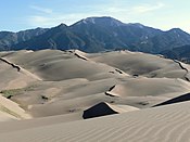
The Sangre de Cristo Range is a mountain range in the Rocky Mountains in southern Colorado in the United States, running north and south along the east side of the Rio Grande Rift. The mountains extend southeast from Poncha Pass for about 75 mi (121 km) through south-central Colorado to La Veta Pass, approximately 20 mi (32 km) west of Walsenburg, and form a high ridge separating the San Luis Valley on the west from the watershed of the Arkansas River on the east. The Sangre de Cristo Range rises over 7,000 ft (2,100 m) above the valleys and plains to the west and northeast.

<span class="mw-page-title-main">Glorieta Pass</span> Mountain pass in New Mexico

Glorieta Pass is a mountain pass in the Sangre de Cristo Mountains of northern New Mexico. The pass is at a strategic location near at the southern end of the Sangre de Cristos in east central Santa Fe County southeast of the city of Santa Fe.

<span class="mw-page-title-main">Wheeler Peak (New Mexico)</span> Mountain

Wheeler Peak is the highest natural point in the U.S. state of New Mexico. It is located northeast of Taos and south of Red River in the northern part of the state, and just 2 miles (3.2 km) southeast of the ski slopes of Taos Ski Valley. It lies in the Sangre de Cristo Mountains, the southernmost subrange of the Rocky Mountains. The peak's elevation is 13,167 feet (4,013 m).

<span class="mw-page-title-main">Blanca Peak</span> Mountain in Colorado, United States

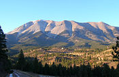
Blanca Peak is the fourth highest summit of the Rocky Mountains of North America and the U.S. state of Colorado. The ultra-prominent 14,351-foot (4,374 m) peak is the highest summit of the Sierra Blanca Massif, the Sangre de Cristo Range, and the Sangre de Cristo Mountains. The fourteener is located 9.6 miles (15.5 km) north by east of the Town of Blanca, on the drainage divide separating Rio Grande National Forest and Alamosa County from the Sangre de Cristo Land Grant and Costilla County. The summit is the highest point of both counties and the entire drainage basin of the Rio Grande. Below the steep North Face of Blanca Peak two live Glaciers once developed, until extinction sometime after 1903. North & South Blanca Glaciers were located at 37° 35N.,longitude 105° 28W. Blanca Peak is higher than any point in the United States east of its longitude.

<span class="mw-page-title-main">Raton Pass</span> Interstate mountain pass in the United States

Ratón Pass is a 7,834 ft (2,388 m) elevation mountain pass on the Colorado–New Mexico border in the western United States. It is located on the eastern side of the Sangre de Cristo Mountains between Trinidad, Colorado and Raton, New Mexico, approximately 180 miles (290 km) northeast of Santa Fe. Ratón is Spanish for "mouse". The pass crosses the line of volcanic mesas that extends east from the Sangre de Cristo Mountains along the state line, and furnishes the most direct land route between the valley of the Arkansas River to the north and the upper valley of the Canadian River, leading toward Santa Fe, to the south. The pass now carries Interstate 25 and railroad tracks.

<span class="mw-page-title-main">Santa Fe Baldy</span>

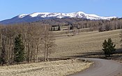
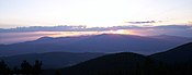
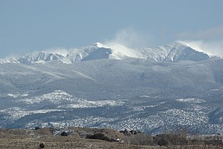
Santa Fe Baldy is a prominent summit in the Sangre de Cristo Mountains of New Mexico, United States, located 15 mi (24 km) northeast of Santa Fe. There are no higher mountains in New Mexico south of Santa Fe Baldy. It is prominent as seen from Los Alamos and communities along the Rio Grande in northern New Mexico, but is relatively inconspicuous from Santa Fe, as its north-south trending main ridge line is seen nearly end-on, disguising the size of the mountain. Tree line in the Sangre de Cristos is unusually high and only the top 600 to 800 feet of the mountain is perpetually free of trees, but several severe forest fires have created bare spots extending to lower elevations. An extensive region of aspen trees on its flanks produces spectacular orange-yellow coloration during the fall that is the subject of many photographic studies.

<span class="mw-page-title-main">Baldy Mountain (Colfax County, New Mexico)</span> Mountain peak in New Mexico, US

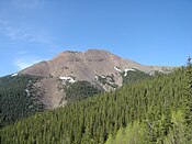
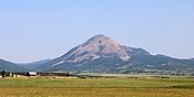
Baldy Mountain, Baldy Peak, Mount Baldy, or Old Baldy is the highest peak in the Cimarron Range, a subrange of the Sangre de Cristo Mountains of New Mexico. It is located in Colfax County, about 6 miles (10 km) northeast of Eagle Nest. It rises abruptly, with 3,640 feet (1,110 m) of vertical relief, from the Moreno Valley to the west and has a total elevation of 12,441 feet (3,792 m).

<span class="mw-page-title-main">Carson National Forest</span>

Carson National Forest is a national forest in northern New Mexico, United States. It encompasses 6,070 square kilometers and is administered by the United States Forest Service. The Forest Service's "mixed use" policy allows for its use for recreation, grazing, and resource extraction.
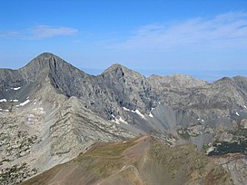
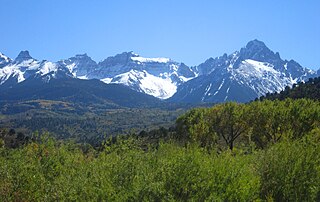
<span class="mw-page-title-main">Truchas Peak</span>

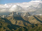
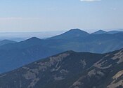
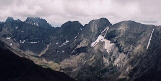
Truchas Peak is the second highest peak in the U.S. State of New Mexico behind Wheeler Peak. It is in the Sangre de Cristo Mountains 26 miles (42 km) northeast of Santa Fe. It lies within the Pecos Wilderness, part of the Santa Fe National Forest. The name of the peak is Spanish for "trout" (plural). It is the highest point in both Rio Arriba and Mora counties. It is also the most southerly peak and land area in the continental United States to rise above 13,000 feet (3,962 m).

<span class="mw-page-title-main">East Spanish Peak</span>

East Spanish Peak is a prominent mountain summit that is the lower of the two Spanish Peaks in the Rocky Mountains of North America. The 12,688-foot (3,867 m) peak is located in the Spanish Peaks Wilderness of San Isabel National Forest, 9.3 miles (14.9 km) southeast by south of the Town of La Veta, Colorado, United States, on the drainage divide between Huerfano and Las Animas counties. The Spanish Peaks are two large igneous stocks which form an eastern outlier of the Culebra Range, a subrange of the Sangre de Cristo Mountains. East Spanish Peak is higher than any point in the United States east of its longitude; it is also the easternmost point in the United States over 12,000 feet (3,700 m), 11,000 feet (3,400 m), and 10,000 feet (3,000 m) feet above sea level.

<span class="mw-page-title-main">Southern Rocky Mountains</span> Major subrange of the Rocky Mountains in the Western United States

The Southern Rocky Mountains are a major subregion of the Rocky Mountains of North America located in the southeastern portion of the U.S. state of Wyoming, the central and western portions of Colorado, the northern portion of New Mexico, and extreme eastern portions of Utah. The Southern Rocky Mountains are also commonly known as the Southern Rockies, and since the highest peaks are located in the State of Colorado, they are sometimes known as the Colorado Rockies, although many important ranges and peaks rise in the other three states. The Southern Rockies include the highest mountain ranges of the Rocky Mountains and include all 30 of the highest major peaks of the Rockies.

The Pecos Wilderness is a protected wilderness area within the Santa Fe National Forest and Carson National Forest. The Pecos Wilderness lies within the Camino Real Ranger District of the Carson National Forest, and the Pecos Ranger District and Espanola Ranger District of the Santa Fe National Forest. The Pecos Wilderness includes the southernmost extension of the Rocky Mountains in the sub-range of the Sangre de Cristo Mountains of north central New Mexico. One trail head for the wilderness is only 15 miles by road from Santa Fe, the state capital. Covering an area of 223,667 acres (90,515 ha)(350 sq mi) it is the second largest wilderness in the state after the Gila Wilderness. An area of fewer than 200,000 acres (81,000 ha) was given wilderness protection by Congress in 1964. Congress protected an additional 55,000 acres (22,000 ha) in 1980. The Wilderness boasts one of the highest concentrations of peaks exceeding 12,000 feet (3,700 m) in elevation in New Mexico, including Santa Fe Baldy, 12,622 feet (3,847 m), the highest point in Santa Fe County, and South Truchas Peak, 13,102 feet (3,993 m), the second highest peak in the state.

<span class="mw-page-title-main">Mount Phillips (New Mexico)</span>

Mount Phillips, formerly called Clear Creek Mountain was renamed in 1960 in honor of the then living Waite Phillips, who donated the area to the Boy Scouts of America. It is located in Colfax County about 11 miles (18 km) south of Baldy Mountain in the Cimarron Range, a subrange of the Sangre de Cristo Mountains of New Mexico.

References

  1. Julyan, Robert (1998). The Place Names of New Mexico. University of New Mexico Press. ISBN   978-0826316899.
  2. Dawson, John Frank (1954). Place names in Colorado: why 700 communities were so named, 150 of Spanish or Indian origin. Denver, CO: The J. Frank Dawson Publishing Co. p. 45.
  3. Chronic, Halka (1998). Roadside Geology of Colorado. Mountain Press Publishing Company. p. 36. ISBN   0-87842-105-X.
  4. "National Registry of Natural Landmarks" (PDF). National Park Service. June 2009.
  5. "Culebra Peak | Colorado Fourteeners Initiative".
  6. "Colorado Fourteeners Initiative: Peaks: Sangre de Cristo Range: Culebra Peak". Archived from the original on 2006-09-09. Retrieved 2006-08-21.
  7. "Climate San Luis". U.S. Climate Data. Retrieved 1 October 2022.
  8. 1 2 Butterfield, Mike; Greene, Peter (2006). Mike Butterfield's Guide to the Mountains of New Mexico. New Mexico Magazine Press. ISBN   978-0-937206-88-1.
  9. 1 2 3 4 5 6 7 8 9 10 11 12 13 The elevation of this summit has been converted from the National Geodetic Vertical Datum of 1929 (NGVD 29) to the North American Vertical Datum of 1988 (NAVD 88). National Geodetic Survey
  10. "Truchas Peak". NGS Data Sheet. National Geodetic Survey, National Oceanic and Atmospheric Administration, United States Department of Commerce . Retrieved 2 January 2023.
  11. "Santa Fe Baldy". NGS Data Sheet. National Geodetic Survey, National Oceanic and Atmospheric Administration, United States Department of Commerce.
  12. "Baldy Mountain". NGS Data Sheet. National Geodetic Survey, National Oceanic and Atmospheric Administration, United States Department of Commerce.
  13. "Greenhorn Mountain". NGS Data Sheet. National Geodetic Survey, National Oceanic and Atmospheric Administration, United States Department of Commerce.
  14. Woodward, Lee A. (1987). "Tectonic framework of northeastern New Mexico and adjacent parts of Colorado, Oklahoma and Texas" (PDF). New Mexico Geological Society Field Conference Series. 38: 80. Retrieved 19 May 2020.