Electric Peak (San Juan Mountains)

Last updated
Electric Peak
Electric Peak, US Highway 550 - Colorado.jpg
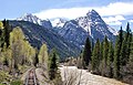
Northwest aspect centered
(Top of Arrow Peak visible directly behind Electric. Trinity Peaks to left, Graystone Peak to right.)
Highest point
Elevation 13,292 ft (4,051 m) [1]
Prominence 812 ft (247 m) [1]
Parent peak Graystone Peak (13,489 ft) [2]
Isolation 0.58 mi (0.93 km) [2]
Coordinates 37°41′56″N107°37′02″W / 37.6989661°N 107.6172295°W / 37.6989661; -107.6172295 Coordinates: 37°41′56″N107°37′02″W / 37.6989661°N 107.6172295°W / 37.6989661; -107.6172295 [3]
Geography
USA Colorado relief location map.svg
Red triangle with thick white border.svg
Electric Peak
Location in Colorado
Usa edcp relief location map.png
Red triangle with thick white border.svg
Electric Peak
Electric Peak (the United States)
Location San Juan County, Colorado, US
Parent range Rocky Mountains
San Juan Mountains
Needle Mountains [1]
Topo map USGS Storm King Peak
Geology
Age of rock Statherian
Mountain type Intrusive
Type of rock Quartzite
Climbing
Easiest route class 2 [2] South Face [4]

Electric Peak is a 13,292-foot-elevation (4,051-meter) mountain summit located in San Juan County, Colorado, United States. [3] It is situated eight miles south of the community of Silverton, in the Weminuche Wilderness, on land managed by San Juan National Forest. It is part of the Needle Mountains which are a subset of the San Juan Mountains, which in turn is a subset of the Rocky Mountains. Precipitation runoff from the mountain drains into tributaries of the Animas River. The peak can be seen from U.S. Route 550 and the Durango and Silverton Narrow Gauge Railroad. Topographic relief is significant as the west aspect rises over 4,500 feet (1,400 meters) above the river and railway in approximately two miles. It is set five miles west of the Continental Divide, and one mile east of Mount Garfield. The mountain's name, which has been officially adopted by the United States Board on Geographic Names, was in use before 1906 when Henry Gannett published it in the Gazetteer of Colorado. [5]

Contents

Climate

According to the Köppen climate classification system, Electric Peak is located in an alpine subarctic climate zone with very long, cold, snowy winters, and cool to warm summers. [6] Due to its altitude, it receives precipitation all year, as snow in winter, and as thunderstorms in summer, with a dry period in late spring.

Geology

Electric Peak is part of the Uncompahgre Formation, which is a sequence of quartzite and black phyllite some 8,200 feet (2,500 meters) in thickness. [7] The formation dates to the Statherian period and is interpreted as metamorphosed marine and fluvial sandstone, mudstone, and shale. The formation overlies plutons with an age of 1,707 million years.

Related Research Articles

<span class="mw-page-title-main">Silverton, Colorado</span> Town in and county seat of San Juan County, Colorado, United States

Silverton is a statutory town that is the county seat, the most populous community, and the only incorporated municipality in San Juan County, Colorado, United States. The town is located in a remote part of the western San Juan Mountains, a range of the Rocky Mountains. The first mining claims were made in mountains above the Silverton in 1860, near the end of the Colorado Gold Rush and when the land was still controlled by the Utes. Silverton was established shortly after the Utes ceded the region in the 1873 Brunot Agreement, and the town boomed from silver mining until the Panic of 1893 led to a collapse of the silver market, and boomed again from gold mining until the recession caused by the Panic of 1907. The entire town is included as a federally designated National Historic Landmark District, the Silverton Historic District.

<span class="mw-page-title-main">Mount Garfield (San Juan County, Colorado)</span>

Mount Garfield is a 13,074-foot-elevation (3,985-meter) mountain summit located in San Juan County, Colorado, United States. It is situated eight miles south of the community of Silverton, in the Weminuche Wilderness, on land managed by San Juan National Forest. It is part of the San Juan Mountains range which is a subset of the Rocky Mountains of North America. Precipitation runoff from the mountain drains into tributaries of the Animas River. The peak can be seen from U.S. Route 550 and the Durango and Silverton Narrow Gauge Railroad. Topographic relief is significant as the west aspect rises over 4,300 feet above the river and railway in approximately one mile. It is set six miles west of the Continental Divide, one mile west of Electric Peak, and three miles east-southeast of Snowdon Peak.

<span class="mw-page-title-main">Snowdon Peak</span> Mountain in Colorado, United States

Snowdon Peak is a 13,077-foot-elevation (3,986-meter) mountain summit located in San Juan County, Colorado, United States. It is situated seven miles south of the community of Silverton, in the Weminuche Wilderness, on land managed by San Juan National Forest. It is part of the San Juan Mountains range which is a subset of the Rocky Mountains of North America, and is set nine miles west of the Continental Divide. Topographic relief is significant as the east aspect rises 4,300 feet above the Animas River in approximately 1.5 mile. Neighbors include Mount Garfield three miles to the east-southeast, and Twilight Peak, which is the nearest higher peak, 3.7 miles to the south-southwest. This mountain can be seen from U.S. Route 550. The mountain is named after Snowdon, the highest mountain in Wales.

<span class="mw-page-title-main">Sunshine Mountain</span>

Sunshine Mountain is a 12,930-foot-elevation (3,940-meter) mountain summit located in San Miguel County, in Colorado, United States. It is situated nine miles southwest of the community of Telluride, in the Lizard Head Wilderness, on land managed by Uncompahgre National Forest. It is part of the San Juan Mountains which is a subset of the Rocky Mountains. Sunshine Mountain is situated 24 miles west of the Continental Divide, 2.75 miles east of Wilson Peak, and 1.8 mile northeast of Lizard Head, the nearest higher neighbor. Topographic relief is significant as the west aspect rises 2,700 feet above Bilk Creek in approximately one mile. The mountain is composed of rock of the San Juan Formation overlaying Telluride Conglomerate, in turn overlaying Mancos Shale. The mountain's name, which has been officially adopted by the United States Board on Geographic Names, was in use before 1899 when Henry Gannett published it in A Dictionary of Altitudes in the United States.

<span class="mw-page-title-main">Potosi Peak</span> Mountain in Colorado, United States

Potosi Peak is a 13,786-foot-elevation (4,202-meter) mountain summit located in Ouray County of Colorado, United States. It is situated five miles southwest of the community of Ouray, on land managed by Uncompahgre National Forest. It is part of the Sneffels Range which is a subset of the San Juan Mountains, which in turn is part of the Rocky Mountains. It is situated west of the Continental Divide, 2.2 miles south of Whitehouse Mountain, and 2.5 miles southeast of Mount Sneffels. Potosi ranks as the 113th-highest peak in Colorado, and the fourth-highest in the Sneffels Range. Recreation enthusiasts heading for Yankee Boy Basin traverse below the southern base of the mountain. Topographic relief is significant as the southeast aspect rises 4,000 feet above the Camp Bird Mine in approximately 1.5 mile. The mining activity in the immediate area produced significant amounts of gold and silver. "Potosi" in Quechuan language translates to "great wealth.". The mountain's name, which has been officially adopted by the United States Board on Geographic Names, was in use before 1899 when Henry Gannett published it in A Dictionary of Altitudes in the United States.

<span class="mw-page-title-main">Mount Emma</span>

Mount Emma is a 13,581-foot-elevation (4,139-meter) mountain summit located in San Miguel County of Colorado, United States. It is situated three miles north of the community of Telluride, on the south side of Yankee Boy Basin, in the Uncompahgre National Forest. It is part of the Sneffels Range which is a subset of the San Juan Mountains, which in turn is part of the Rocky Mountains. Mount Emma is situated west of the Continental Divide, two miles south of Mount Sneffels, and 0.8 mile south of Gilpin Peak, the nearest higher neighbor. Emma ranks as the 197th-highest peak in Colorado, and the 10th-highest in the Sneffels Range. Topographic relief is significant as the south aspect rises 4,830 feet above Telluride in approximately three miles. An ascent of Mt. Emma is a difficult climb with 2,180 feet of elevation gain covering three miles from Yankee Boy Basin, or 4,836 feet of elevation gain from Telluride. This mountain's name was officially adopted by the U.S. Board on Geographic Names.

<span class="mw-page-title-main">Coxcomb Peak (Colorado)</span>

Coxcomb Peak is a 13,656-foot-elevation (4,162-meter) mountain summit located on the common boundary of Hinsdale County and Ouray County, in Colorado, United States. It is situated nine miles northeast of the community of Ouray, in the Uncompahgre Wilderness, on land managed by Uncompahgre National Forest. It is part of the San Juan Mountains which are a subset of the Rocky Mountains, and is situated west of the Continental Divide. Coxcomb ranks as the 171st-highest peak in Colorado, and topographic relief is significant as the south aspect rises 2,000 feet above Wetterhorn Basin in approximately one mile, and 4,400 feet above Cow Creek in three miles. Neighbors include Precipice Peak 2.7 miles to the north, Redcliff one-half mile north, Matterhorn Peak 2.3 miles to the east-southeast, and nearest higher neighbor Wetterhorn Peak 1.8 mile to the southeast. The mountain's descriptive name, which has been officially adopted by the United States Board on Geographic Names, was in use since at least 1906 when Henry Gannett published it in the Gazetteer of Colorado.

<span class="mw-page-title-main">Whitehouse Mountain</span>

Whitehouse Mountain is a 13,492-foot-elevation (4,112-meter) mountain summit located in Ouray County of southwest Colorado, United States. It is situated four miles west of the community of Ouray, on land managed by Uncompahgre National Forest. It is part of the Sneffels Range which is a subset of the San Juan Mountains, which in turn is part of the Rocky Mountains. It is west of the Continental Divide, 2.2 miles north of Potosi Peak, and 3.2 miles east-northeast of Mount Sneffels. Topographic relief is significant as the east aspect rises 5,680 feet above the town of Ouray in approximately four miles. The mountain's name, which has been officially adopted by the United States Board on Geographic Names, was in use before 1906 when Henry Gannett published it in the Gazetteer of Colorado.

<span class="mw-page-title-main">American Peak</span>

American Peak is a 13,806-foot-elevation (4,208-meter) mountain summit located in Hinsdale County, of southwest Colorado, United States. It is situated 11 miles northeast of the community of Silverton, on land managed by the Bureau of Land Management. It is part of the San Juan Mountains which is a subset of the Rocky Mountains, and is situated four miles west of the Continental Divide. American Peak ranks as the 102nd-highest peak in Colorado, and topographic relief is significant as the south aspect rises 2,800 feet above Snare Creek in approximately 1.5 mile. Neighbors include Handies Peak one mile to the north-northeast, and Jones Mountain, 0.8 mile to the west-southwest. The mountain's name was officially adopted in 2005 by the United States Board on Geographic Names to recognize the American spirit and heritage, and the summit's proximity to American Basin.

<span class="mw-page-title-main">Engineer Mountain</span> Mountain in Colorado, United States

Engineer Mountain is a 12,968-foot-elevation (3,953-meter) mountain summit located in San Juan County, Colorado, United States. It is part of the San Juan Mountains range which is a subset of the Rocky Mountains, and is west of the Continental Divide. Engineer Mountain is a prominent landmark set 1.5 mile immediately west of Coal Bank Pass, and is visible from multiple viewpoints along Highway 550, making it one of the most photographed mountains in the San Juans. It is situated 11 miles southwest of the community of Silverton, on land managed by San Juan National Forest. Topographic relief is significant as the southwest aspect rises 3,800 feet above Cascade Creek in approximately two miles. Neighbors include Snowdon Peak seven miles to the east, and Twilight Peak, five miles to the southeast.

<span class="mw-page-title-main">Cirque Mountain (Colorado)</span> Mountain in Colorado, United States

Cirque Mountain is a 13,686-foot-elevation (4,171-meter) mountain summit located in Ouray County of southwest Colorado, United States. It is situated six miles west of the community of Ouray, above the north side of Yankee Boy Basin, on land managed by Uncompahgre National Forest. It is part of the Sneffels Range which is a subset of the San Juan Mountains, which in turn is part of the Rocky Mountains. Cirque ranks as the 155th-highest peak in Colorado, and the ninth-highest in the Sneffels Range. It is west of the Continental Divide, 1.12 mile east of Mount Sneffels, and 0.59 mile west of Teakettle Mountain, which is the nearest higher neighbor. Topographic relief is significant as the north aspect rises 3,000 feet above Blaine Basin in one mile, and the south aspect rises over 2,000 feet above Yankee Boy Basin in less than one mile. These basins are cirques which were carved by ancient glaciers. The mountain's name has been officially adopted by the United States Board on Geographic Names.

<span class="mw-page-title-main">Courthouse Mountain</span>

Courthouse Mountain is a 12,152-foot-elevation (3,704-meter) mountain summit located on the shared boundary of Hinsdale County with Ouray County, in southwest Colorado, United States. It is situated 10.5 miles east of the community of Ridgway, and south of Owl Creek Pass, in the Uncompahgre Wilderness, on land managed by Uncompahgre National Forest. It is part of the San Juan Mountains which are a subset of the Rocky Mountains, and is situated west of the Continental Divide. Topographic relief is significant as the east aspect rises nearly 2,000 feet above West Fork Cimarron River in approximately one-half mile, and with its prominence can be seen from Highway 550 near Ridgway. The mountain's name, which has been officially adopted by the United States Board on Geographic Names, was in use before 1906 when Henry Gannett published it in the Gazetteer of Colorado.

<span class="mw-page-title-main">Wildhorse Peak</span>

Wildhorse Peak is a 13,266-foot-elevation (4,043-meter) mountain summit located in Ouray County, of Colorado, United States. It is situated five miles east of the community of Ouray, in the Uncompahgre Wilderness, on land managed by Uncompahgre National Forest. It is part of the San Juan Mountains which are a subset of the Rocky Mountains, and is situated west of the Continental Divide. Neighbors include Darley Mountain 2.2 miles to the south, and Abrams Mountain five miles to the southwest. This distinctive peak abruptly rises 1,000 feet above the alpine tundra of American Flats, and topographic relief is significant as the northwest aspect rises 1,600 feet above Wildhorse Creek in less than one mile. The peak can be seen from Montrose and Highway 550. The first ascent of the summit was made August 25, 1899, by Eli Stanton, F. H. Stanton, and William Killen. The mountain's name, which has been officially adopted by the United States Board on Geographic Names, was in use in 1906 when Henry Gannett published it in A Gazetteer of Colorado.

<span class="mw-page-title-main">Golden Horn (Colorado)</span> Mountain summit in southwest Colorado

Golden Horn is a 13,780-foot-elevation (4,200-meter) mountain summit located on the shared boundary of San Juan County with San Miguel County, in southwest Colorado, United States. It is situated nine miles west of the community of Silverton, on land managed by San Juan National Forest and Uncompahgre National Forest. Golden Horn is part of the San Juan Mountains which are a subset of the Rocky Mountains, and is west of the Continental Divide. It ranks as the 116th-highest peak in Colorado, and topographic relief is significant as the west aspect rises 3,800 feet in approximately 1.5 mile. The mountain's name, which has been officially adopted by the United States Board on Geographic Names, was in use in 1906 when Henry Gannett published it in A Gazetteer of Colorado.

<span class="mw-page-title-main">Hurricane Peak</span>

Hurricane Peak is a 13,447-foot-elevation (4,099-meter) mountain summit located in San Juan County of southwest Colorado, United States. It is situated equidistant between the historic towns of Ouray and Silverton, and is approximately nine miles west of the Continental Divide. It is part of the San Juan Mountains which are a subset of the Rocky Mountains. Topographic relief is significant as the north aspect rises 1,200 feet above Lake Como in one-half mile. Neighbors include Abrams Mountain 3.4 miles to the north, and Red Mountain 2.2 miles to the west. The Mountain Queen Mine, which is located on the east slope of Hurricane Peak at the head of California Gulch, is one of the oldest workings in the area and was most active from 1878 to 1880. The mountain's name, which has been officially adopted by the United States Board on Geographic Names, was in use in 1906 when Henry Gannett published it in the Gazetteer of Colorado.

<span class="mw-page-title-main">Lookout Peak (Colorado)</span>

Lookout Peak is a 13,661-foot-elevation (4,164-meter) mountain summit located on the shared boundary of San Juan County with San Miguel County, in southwest Colorado, United States. It is situated three miles east of the community of Ophir, and one mile immediately north of Ophir Pass, on land managed by San Juan National Forest and Uncompahgre National Forest. Lookout Peak is part of the San Juan Mountains which are a subset of the Rocky Mountains, and is west of the Continental Divide. It ranks as the 166th-highest peak in Colorado, and topographic relief is significant as the west aspect rises 3,000 feet in approximately one mile. Neighbors include Silver Mountain three miles to the west-northwest, Wasatch Mountain two miles north-northwest, and Golden Horn five miles south-southwest. The mountain's name, which has been officially adopted by the United States Board on Geographic Names, was in use in 1899 when Henry Gannett published it in A Dictionary of Altitudes in the United States, and in 1906 when he published it in A Gazetteer of Colorado.

<span class="mw-page-title-main">Sheep Mountain (San Miguel and Dolores Counties, Colorado)</span>

Sheep Mountain is a 13,188-foot-elevation (4,020-meter) mountain summit located on the shared boundary of Dolores County with San Miguel County, in southwest Colorado, United States. It is situated three miles south of Trout Lake and two miles southeast of Lizard Head Pass, on land managed by San Juan National Forest and Uncompahgre National Forest. Sheep Mountain is part of the San Juan Mountains which are a subset of the Rocky Mountains, and is west of the Continental Divide. Topographic relief is significant as the southwest aspect rises 3,200 feet above the Dolores River in approximately 2.5 miles. Neighbors include Golden Horn and Vermilion Peak to the east, and Lizard Head to the northwest. Sheep Mountain can be seen from the San Juan Skyway in the Lizard Head Pass and Trout Lake areas. The mountain's name, which has been officially adopted by the United States Board on Geographic Names, was in use in 1906 when Henry Gannett published it in A Gazetteer of Colorado.

<span class="mw-page-title-main">Twin Sisters (Colorado)</span>

Twin Sisters is a 13,432-foot-elevation (4,094-meter) mountain summit located in San Juan County, Colorado, United States. The lower west summit has an elevation of 13,374 feet and 0.43 mile separates the pair. Twin Sisters is part of the San Juan Mountains range which is a subset of the Rocky Mountains, and is west of the Continental Divide. It is situated 7.5 miles southwest of the community of Silverton, on land managed by San Juan National Forest. It is set 5.5 miles north of Engineer Mountain, and 2.2 miles east of Rolling Mountain, the nearest higher neighbor. Other neighbors include Snowdon Peak seven miles to the southeast, and Golden Horn, 3.5 miles to the northwest. Topographic relief is significant as the north aspect rises 3,000 feet above South Fork Mineral Creek in approximately 1.5 mile. The mountain's name, which has been officially adopted by the United States Board on Geographic Names, was in use in 1906 when Henry Gannett published it in A Gazetteer of Colorado.

<span class="mw-page-title-main">Ulysses S Grant Peak</span>

Ulysses S Grant Peak is a 13,767-foot-elevation (4,196-meter) mountain summit located on the shared boundary of San Juan County with San Miguel County, in southwest Colorado, United States. It is situated eight miles west of the community of Silverton, on land managed by San Juan National Forest and Uncompahgre National Forest. Ulysses S Grant Peak is part of the San Juan Mountains which are a subset of the Rocky Mountains, and is west of the Continental Divide. It ranks as the 119th-highest peak in Colorado, and topographic relief is significant as the west aspect rises 2,400 feet in approximately one mile. The mountain's name, which has been officially adopted by the United States Board on Geographic Names, was in use in an 1896 scientific publication by Charles Whitman Cross, and listed by Henry Gannett when he published A Gazetteer of Colorado in 1906.

<span class="mw-page-title-main">Pilot Knob (Colorado)</span> Mountain summit in southwest Colorado

Pilot Knob is a 13,738-foot-elevation (4,187-meter) mountain summit located on the shared boundary of San Juan County with San Miguel County, in southwest Colorado, United States. It is situated nine miles west of the community of Silverton, on land managed by San Juan National Forest and Uncompahgre National Forest. Pilot Knob is part of the San Juan Mountains which are a subset of the Rocky Mountains, and is west of the Continental Divide. It ranks as the 132nd-highest peak in Colorado, and topographic relief is significant as the west aspect rises 4,000 feet above Trout Lake in three miles. Neighbors include Ulysses S Grant Peak 1.5 mile to the northeast, and Golden Horn one-half mile to the southeast. The mountain's name, which has been officially adopted by the United States Board on Geographic Names, was listed by Henry Gannett when he published A Gazetteer of Colorado in 1906. The peak is considered one of the most difficult to climb in Colorado because of its poor quality volcanic rock.

References

  1. 1 2 3 "Electric Peak, Colorado". Peakbagger.com.
  2. 1 2 3 "Electric Peak - 13,292' CO". listsofjohn.com. Retrieved 2021-06-29.
  3. 1 2 "Electric Peak". Geographic Names Information System . United States Geological Survey, United States Department of the Interior . Retrieved 2021-06-29.
  4. Robert F. Rosebrough, The San Juan Mountains: A Climbing & Hiking Guide, Cordillera Press, 1986, page 170.
  5. Henry Gannett, Gazetteer of Colorado, 1906, US Government Printing Office, page 64.
  6. Peel, M. C.; Finlayson, B. L.; McMahon, T. A. (2007). "Updated world map of the Köppen−Geiger climate classification". Hydrol. Earth Syst. Sci. 11. ISSN   1027-5606.
  7. Rob Blair, Tom Ann Casey, William H. Romme, The Western San Juan Mountains: Their Geology, Ecology, and Human History, 1996, University Press of Colorado, ISBN   9780870813788, page 350.