The Town of New Castle is a home rule municipality in Garfield County, Colorado, United States. The population was 4,923 at the 2020 census.

Rifle is a home rule municipality in, and the most populous community of, Garfield County, Colorado, United States. The population was 10,437 at the 2020 census. Rifle is a regional center of the cattle ranching industry located along Interstate 70 and the Colorado River just east of the Roan Plateau, which dominates the western skyline of the town. The town was founded in 1882 by Abram Maxfield, and was incorporated in 1905 along Rifle Creek, near its mouth on the Colorado. The community takes its name from the creek.

Rocky Mountain National Park is an American national park located approximately 55 mi (89 km) northwest of Denver in north-central Colorado, within the Front Range of the Rocky Mountains. The park is situated between the towns of Estes Park to the east and Grand Lake to the west. The eastern and western slopes of the Continental Divide run directly through the center of the park with the headwaters of the Colorado River located in the park's northwestern region. The main features of the park include mountains, alpine lakes and a wide variety of wildlife within various climates and environments, from wooded forests to mountain tundra.

The Front Range is a mountain range of the Southern Rocky Mountains of North America located in the central portion of the U.S. State of Colorado, and southeastern portion of the U.S. State of Wyoming. It is the first mountain range encountered as one goes westbound along the 40th parallel north across the Great Plains of North America.

The Green River, located in the western United States, is the chief tributary of the Colorado River. The watershed of the river, known as the Green River Basin, covers parts of the U.S. states of Wyoming, Utah, and Colorado. The Green River is 730 miles (1,170 km) long, beginning in the Wind River Mountains of Wyoming and flowing through Wyoming and Utah for most of its course, except for a short segment of 40 miles (64 km) in western Colorado. Much of the route traverses the arid Colorado Plateau, where the river has carved some of the most spectacular canyons in the United States. The Green is slightly smaller than Colorado when the two rivers merge but typically carries a larger load of silt. The average yearly mean flow of the river at Green River, Utah is 6,121 cubic feet (173.3 m3) per second.

The Colorado Plateau is a physiographic and desert region of the Intermontane Plateaus, roughly centered on the Four Corners region of the southwestern United States. This plateau covers an area of 336,700 km2 (130,000 mi2) within western Colorado, northwestern New Mexico, southern and eastern Utah, northern Arizona, and a tiny fraction in the extreme southeast of Nevada. About 90% of the area is drained by the Colorado River and its main tributaries: the Green, San Juan, and Little Colorado. Most of the remainder of the plateau is drained by the Rio Grande and its tributaries.

The Denver Basin, variously referred to as the Julesburg Basin, Denver-Julesburg Basin, or the D-J Basin, is a geologic structural basin centered in eastern Colorado in the United States, but extending into southeast Wyoming, western Nebraska, and western Kansas. It underlies the Denver-Aurora Metropolitan Area on the eastern side of the Rocky Mountains.
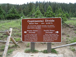
Milner Pass, elevation 10,759 ft (3,279 m) is a mountain pass in the Rocky Mountains of northern Colorado in the United States. It is located on the continental divide in the Front Range, within Rocky Mountain National Park, along the boundary between Larimer and Grand counties. The pass provides the passage over the continental divide for US 34, also known as Trail Ridge Road between Estes Park and Grand Lake. The pass is not, however, the high point on Trail Ridge Road, which crests at 12,183 ft (3,713 m) east of the pass within Rocky Mountain National Park. Along with the rest of Trail Ridge Road, the pass is generally closed in winter from the first heavy snow fall until the opening of the road around Memorial Day. The gentle pass divides the headwaters of the Cache la Poudre River and several creeks near the headwaters of the Colorado River to the west. The road near the pass provides a panoramic view of the Never Summer Mountains to the west.

The Dakota Hogback is a long hogback ridge at the eastern fringe of the Rocky Mountains that extends north-south from southern Wyoming through Colorado and into northern New Mexico in the United States. The ridge is prominently visible as the first line of foothills along the edge of the Great Plains. It is generally faulted along its western side, and varies in height, with gaps in numerous locations where rivers exit the mountains. The ridge takes its name from the Dakota Formation, a formation with resistant sandstone beds that cap the ridge. The hogback was formed during the Laramide orogeny, approximately 50 million years ago, when the modern Rockies were created. The general uplift to the west created long faulting in the North American Plate, resulting in the creation of the hogback.

A monocline is a step-like fold in rock strata consisting of a zone of steeper dip within an otherwise horizontal or gently dipping sequence.

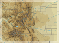
The geography of the U.S. State of Colorado is diverse, encompassing both rugged mountainous terrain, vast plains, desert lands, desert canyons, and mesas. Colorado is a landlocked U.S. state. In 1861, the United States Congress defined the boundaries of the new Territory of Colorado exclusively by lines of latitude and longitude, stretching from 37°N to 41°N latitude, and from 102°02'48"W to 109°02'48"W longitude. Starting in 1868, official surveys demarcated the boundaries, deviating from the parallels and meridians in several places. Later surveys attempted to correct some of these mistakes but in 1925 the U.S. Supreme Court affirmed that the earlier demarcation was the official boundary. The borders of Colorado are now officially defined by 697 boundary markers connected by straight boundary lines. Colorado, Wyoming, and Utah are the only states that have their borders defined solely by straight boundary lines with no natural features. The southwest corner of Colorado is the Four Corners Monument at 36°59'56"N, 109°2'43"W. This is the only place in the United States where four states meet: Colorado, New Mexico, Arizona, and Utah.

Wills Mountain is a quartzite-capped ridge in the Ridge and Valley physiographic province of the Appalachian Mountains in Pennsylvania and Maryland, extending from near Bedford, Pennsylvania, to near Cumberland, Maryland. It is the northernmost of several mountain ridges included within the Wills Mountain Anticline.

In geology and geomorphology, a hogback or hog's back is a long, narrow ridge or a series of hills with a narrow crest and steep slopes of nearly equal inclination on both flanks. Typically, the term is restricted to a ridge created by the differential erosion of outcropping, steeply dipping, homoclinal, and typically sedimentary strata. One side of a hogback consists of the surface of a steeply dipping rock stratum called a dip slope. The other side is an erosion face that cuts through the dipping strata that comprises the hogback. The name "hogback" comes from the Hog's Back of the North Downs in Surrey, England, which refers to the landform's resemblance in outline to the back of a hog. The term is also sometimes applied to drumlins and, in Maine, to both eskers and ridges known as "horsebacks".

The Dakota is a sedimentary geologic unit name of formation and group rank in Midwestern North America. The Dakota units are generally composed of sandstones, mudstones, clays, and shales deposited in the Mid-Cretaceous opening of the Western Interior Seaway. The usage of the name Dakota for this particular Albian-Cenomanian strata is exceptionally widespread; from British Columbia and Alberta to Montana and Wisconsin to Colorado and Kansas to Utah and Arizona. It is famous for producing massive colorful rock formations in the Rocky Mountains and the Great Plains of the United States, and for preserving both dinosaur footprints and early deciduous tree leaves.

The Navajo Section is a physiographic section of the larger Colorado Plateaus Province, which in turn is part of the larger Intermontane Plateaus physiographic Division.

In structural geology, a homocline or homoclinal structure, is a geological structure in which the layers of a sequence of rock strata, either sedimentary or igneous, dip uniformly in a single direction having the same general inclination in terms of direction and angle. A homocline can be associated with either one limb of a fold, the edges of a dome, the coast-ward tilted strata underlying a coastal plain, slice of thrust fault, or a tilted fault block. When the homoclinal strata consists of alternating layers of rock that vary hardness and resistance to erosion, their erosion produces either cuestas, homoclinal ridges, or hogbacks depending on the angle of dip of the strata. On a topographic map, the landfroms associated with homoclines exhibit nearly parallel elevation contour lines that show a steady change in elevation in a given direction. In the subsurface, they characterize by parallel structural contour lines.

Dinosaur Ridge is a segment of the Dakota Hogback in the Morrison Fossil Area National Natural Landmark located in Jefferson County, Colorado, near the town of Morrison and just west of Denver.

Nescopeck Mountain is a ridge in Columbia County and Luzerne County, in Pennsylvania, in the United States. Its elevation is 1,594 feet (486 m) above sea level. The ridge is a forested ridge, with at least two types of forest and two systems of vernal pools. It is a very long and unbroken ridge with two water gaps: one carved by Catawissa Creek and one carved by Nescopeck Creek. This later gap was exploited as a transportation corridor with the construction of the Lausanne–Nescopeck Turnpike between the respective frontier communities at Lausanne Landing and Nescopeck in 1805 connecting the newly developing Wyoming Valley with Philadelphia and the Delaware River valley; cutting off over 100 miles between Philadelphia and Wilkes-Barre. Today's Route PA 93 derives from this historic pack mule road.
The White River Plateau is a "broad structural dome" located north of Glenwood Springs, Colorado and north of the Colorado River in the United States. Also called the White River Uplift, the mountainous area is shown on maps as being roughly circular in area, occupying parts of the Colorado counties of Garfield and Rio Blanco, with small portions extending into Eagle and Routt counties. The Grand Hogback marks parts of the plateau's southern and western boundaries. The Flat Tops mountain range is part of the White River Plateau, and much of the plateau is located within the White River National Forest.