
East Spanish Peak is a prominent mountain summit that is the lower of the two Spanish Peaks in the Rocky Mountains of North America. The 12,688-foot (3,867 m) peak is located in the Spanish Peaks Wilderness of San Isabel National Forest, 9.3 miles (14.9 km) southeast by south of the Town of La Veta, Colorado, United States, on the drainage divide between Huerfano and Las Animas counties. The Spanish Peaks are two large igneous stocks which form an eastern outlier of the Culebra Range, a subrange of the Sangre de Cristo Mountains. East Spanish Peak is higher than any point in the United States east of its longitude; it is also the easternmost point in the United States over 12,000 feet (3,700 m), 11,000 feet (3,400 m), and 10,000 feet (3,000 m) feet above sea level.
Mount Gunnison is a prominent mountain summit in the West Elk Mountains range of the Rocky Mountains of North America. The 12,725-foot (3,879 m) peak is located in the West Elk Wilderness of Gunnison National Forest, 22.2 miles (35.7 km) west by south of the Town of Crested Butte in Gunnison County, Colorado, United States. The mountain is named in honor of John Williams Gunnison who explored the area.
Castle Peak is a prominent mountain summit in the northern Sawatch Range of the Rocky Mountains of North America. The 11,305-foot (3,446 m) peak is located 9.6 miles (15.5 km) north of the Town of Eagle in Eagle County, Colorado, United States.

Chair Mountain is a prominent mountain summit in the Elk Mountains range of the Rocky Mountains of North America. The 12,727-foot (3,879 m) peak is located in the Raggeds Wilderness of Gunnison National Forest, 5.0 miles (8.1 km) west by south of the Town of Marble in Gunnison County, Colorado, United States.

Mount Guero is a prominent mountain summit in the West Elk Mountains range of the Rocky Mountains of North America. The 12,058-foot (3,675 m) peak is located in the West Elk Wilderness of the Gunnison National Forest, 13 miles (21 km) east of Crawford, Colorado in Delta County and 24.3 miles (39.1 km) west-southwest of the Town of Crested Butte in Gunnison County, Colorado, United States.

Marcellina Mountain is a prominent mountain summit in the West Elk Mountains range of the Rocky Mountains of North America. The 11,353-foot (3,460 m) peak is located in the Raggeds Wilderness of Gunnison National Forest, 15.0 miles (24.1 km) west by north of the Town of Crested Butte in Gunnison County, Colorado, United States.
Horse Mountain is a prominent mountain summit in the San Juan Mountains range of the Rocky Mountains of North America. The 9,952-foot (3,033 m) peak is located in San Juan National Forest, 15.8 miles (25.5 km) west by north of the Town of Pagosa Springs in Archuleta County, Colorado, United States.

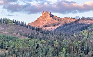
Gothic Mountain is a prominent mountain summit in the Elk Mountains range of the Rocky Mountains of North America. The 12,631-foot (3,850 m) peak is located in Gunnison National Forest, 1.1 miles (1.8 km) west by south of the ghost town of Gothic in Gunnison County, Colorado, United States. Gothic Mountain takes its name from its pinnacles said to resemble Gothic architecture.

Lone Cone is a prominent mountain summit at the western end of the San Miguel Mountains range of the Rocky Mountains of North America. The 12,618-foot (3,846 m) peak is located 24.2 miles (38.9 km) west by south of the Town of Telluride, Colorado, United States, on the drainage divide separating San Juan National Forest and Dolores County from Uncompahgre National Forest and San Miguel County.

Little Cone is a prominent mountain summit in the San Miguel Mountains range of the Rocky Mountains of North America. The 11,988-foot (3,654 m) peak is located in Uncompahgre National Forest, 15.0 miles (24.1 km) west of the Town of Telluride in San Miguel County, Colorado, United States.
Elliot Mountain is a prominent mountain summit in the San Miguel Mountains of the Rocky Mountains of North America. The 12,346-foot (3,763 m) peak is located in San Juan National Forest, 3.5 miles (5.6 km) north-northwest of the Town of Rico in Dolores County, Colorado, United States.

Arrow Peak is a high mountain summit in the Grenadier Range of the Rocky Mountains of North America. The 13,809-foot (4,209 m) thirteener is located in the Weminuche Wilderness of San Juan National Forest, 8.7 miles (14.0 km) south-southeast of the Town of Silverton in San Juan County, Colorado, United States.
Diamond Peak is a prominent mountain summit in the Green River Basin of the U.S. state of Colorado. The 9,665-foot (2,946 m) peak is located 51.0 miles (82.1 km) northwest by west of the community of Maybell in Moffat County, Colorado, United States.
Elk Mountain is a prominent mountain summit in the Rabbit Ears Range of the Rocky Mountains of North America. The 11,424-foot (3,482 m) peak is located in Arapaho National Forest, 12.9 miles (20.8 km) northwest by west of the Town of Granby in Grand County, Colorado, United States.

Green Mountain is a prominent mountain summit in the Kenosha Mountains range of the Rocky Mountains of North America. The 10,427-foot (3,178 m) peak is located in Pike National Forest, 5.2 miles (8.4 km) northwest of the community of Deckers, Colorado, United States, in Jefferson County.
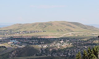
Green Mountain is a mesa on the eastern flank of the Front Range of the Rocky Mountains of North America. The 6,854-foot (2,089 m) mesa summit is located in William Frederick Hayden Park in the City of Lakewood, Colorado, United States, 4.0 miles (6.5 km) west of the municipal center of Lakewood in Jefferson County.

Half Peak is the highest summit of the east central San Juan Mountains in the Rocky Mountains of North America.
Horsefly Peak is the highest summit of the Uncompahgre Plateau in the Rocky Mountains of North America. The 10,353-foot (3,156 m) peak is located 10.0 miles (16.1 km) west by north of the Town of Ridgway in Ouray County, Colorado, United States.

Iron Mountain is a mountain summit in the Never Summer Mountains of the Rocky Mountains of North America. The 12,270-foot (3,740 m) peak is located 2.4 miles (3.8 km) east-southeast of the Cameron Pass, Colorado, United States, on the drainage divide separating State Forest State Park and Jackson County from Roosevelt National Forest and Larimer County.

Mount Owen is the highest summit of the Ruby Range of the Rocky Mountains of North America. The 13,070-foot (3,984 m) thirteener is located in Gunnison National Forest at the edge of the Raggeds Wilderness, 8.5 miles (13.6 km) west-northwest of the Town of Crested Butte in Gunnison County, Colorado, United States.

