| Mount Nimbus | |
|---|---|
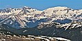
 East aspect | |
| Highest point | |
| Elevation | 12,721 ft (3,877 m) [1] |
| Prominence | 623 ft (190 m) [1] |
| Parent peak | Mount Cumulus (12,729 ft) [1] |
| Isolation | 1.14 mi (1.83 km) [1] |
| Coordinates | 40°23′48″N105°54′15″W / 40.3967585°N 105.9040416°W [2] |
| Naming | |
| Etymology | Nimbus cloud |
| Geography | |
 Mount Nimbus Location in Colorado  Mount Nimbus Mount Nimbus (the United States) | |
| Country | United States |
| State | Colorado |
| County | Grand County |
| Protected area | Rocky Mountain National Park Never Summer Wilderness |
| Parent range | Rocky Mountains Never Summer Mountains |
| Topo map | USGS Mount Richthofen [3] |
| Geology | |
| Rock type(s) | Granite and Gneiss [4] |
| Climbing | |
| Easiest route | class 2 [1] |
Mount Nimbus is a 12,721-foot-elevation (3,877-meter) mountain summit in Grand County, Colorado, United States.