Silverton is a statutory town that is the county seat, the most populous community, and the only incorporated municipality in San Juan County, Colorado, United States. The town is located in a remote part of the western San Juan Mountains, a range of the Rocky Mountains. The first mining claims were made in mountains above the Silverton in 1860, near the end of the Colorado Gold Rush and when the land was still controlled by the Utes. Silverton was established shortly after the Utes ceded the region in the 1873 Brunot Agreement, and the town boomed from silver mining until the Panic of 1893 led to a collapse of the silver market, and boomed again from gold mining until the recession caused by the Panic of 1907. The entire town is included as a federally designated National Historic Landmark District, the Silverton Historic District.

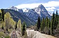
The Needle Mountains are a subrange of the San Juan Mountains of the Rocky Mountains located in the southwestern part of the U.S. State of Colorado. Much of the range is protected in the Weminuche Wilderness of the San Juan National Forest. The range is notable for having some of the most rugged mountains in the state, and includes many technical climbs and scrambles. A small but dramatic east–west subrange in the northern section is known as the Grenadier Range.

Tower Mountain, elevation 13,558 ft (4,132 m), is a summit located northeast of Silverton, Colorado.

Snowdon Peak is a 13,077-foot-elevation (3,986-meter) mountain summit located in San Juan County, Colorado, United States. It is situated seven miles south of the community of Silverton, in the Weminuche Wilderness, on land managed by San Juan National Forest. It is part of the San Juan Mountains range which is a subset of the Rocky Mountains of North America, and is set nine miles west of the Continental Divide. Topographic relief is significant as the east aspect rises 4,300 feet above the Animas River in approximately 1.5 mile. Neighbors include Mount Garfield three miles to the east-southeast, and Twilight Peak, which is the nearest higher peak, 3.7 miles to the south-southwest. This mountain can be seen from U.S. Route 550. The mountain is named after Snowdon, the highest mountain in Wales.

Electric Peak is a 13,292-foot-elevation (4,051-meter) mountain summit located in San Juan County, Colorado, United States. It is situated eight miles south of the community of Silverton, in the Weminuche Wilderness, on land managed by San Juan National Forest. It is part of the Needle Mountains which are a subset of the San Juan Mountains, which in turn is a subset of the Rocky Mountains. Precipitation runoff from the mountain drains into tributaries of the Animas River. The peak can be seen from U.S. Route 550 and the Durango and Silverton Narrow Gauge Railroad. Topographic relief is significant as the west aspect rises over 4,500 feet above the river and railway in approximately two miles. It is set five miles west of the Continental Divide, and one mile east of Mount Garfield. The mountain's name, which has been officially adopted by the United States Board on Geographic Names, was in use before 1906 when Henry Gannett published it in the Gazetteer of Colorado.
Sunshine Mountain is a 12,930-foot-elevation (3,940-meter) mountain summit located in San Miguel County, in Colorado, United States. It is situated nine miles southwest of the community of Telluride, in the Lizard Head Wilderness, on land managed by Uncompahgre National Forest. It is part of the San Juan Mountains which is a subset of the Rocky Mountains. Sunshine Mountain is situated 24 miles west of the Continental Divide, 2.75 miles east of Wilson Peak, and 1.8 mile northeast of Lizard Head, the nearest higher neighbor. Topographic relief is significant as the west aspect rises 2,700 feet above Bilk Creek in approximately one mile. The mountain is composed of rock of the San Juan Formation overlaying Telluride Conglomerate, in turn overlaying Mancos Shale. The mountain's name, which has been officially adopted by the United States Board on Geographic Names, was in use before 1899 when Henry Gannett published it in A Dictionary of Altitudes in the United States.

Mount Emma is a 13,581-foot-elevation (4,139-meter) mountain summit located in San Miguel County of Colorado, United States. It is situated three miles north of the community of Telluride, on the south side of Yankee Boy Basin, in the Uncompahgre National Forest. It is part of the Sneffels Range which is a subset of the San Juan Mountains, which in turn is part of the Rocky Mountains. Mount Emma is situated west of the Continental Divide, two miles south of Mount Sneffels, and 0.8 mile south of Gilpin Peak, the nearest higher neighbor. Emma ranks as the 197th-highest peak in Colorado, and the 10th-highest in the Sneffels Range. Topographic relief is significant as the south aspect rises 4,830 feet above Telluride in approximately three miles. An ascent of Mt. Emma is a difficult climb with 2,180 feet of elevation gain covering three miles from Yankee Boy Basin, or 4,836 feet of elevation gain from Telluride. This mountain's name was officially adopted by the U.S. Board on Geographic Names.
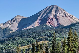
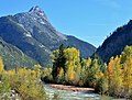
Engineer Mountain is a 12,968-foot-elevation (3,953-meter) mountain summit located in San Juan County, Colorado, United States. It is part of the San Juan Mountains range which is a subset of the Rocky Mountains, and is west of the Continental Divide. Engineer Mountain is a prominent landmark set 1.5 mile immediately west of Coal Bank Pass, and is visible from multiple viewpoints along Highway 550, making it one of the most photographed mountains in the San Juans. It is situated 11 miles southwest of the community of Silverton, on land managed by San Juan National Forest. Topographic relief is significant as the southwest aspect rises 3,800 feet above Cascade Creek in approximately two miles. Neighbors include Snowdon Peak seven miles to the east, and Twilight Peak, five miles to the southeast.

Cirque Mountain is a 13,686-foot-elevation (4,171-meter) mountain summit located in Ouray County of southwest Colorado, United States. It is situated six miles west of the community of Ouray, above the north side of Yankee Boy Basin, on land managed by Uncompahgre National Forest. It is part of the Sneffels Range which is a subset of the San Juan Mountains, which in turn is part of the Rocky Mountains. Cirque ranks as the 155th-highest peak in Colorado, and the ninth-highest in the Sneffels Range. It is west of the Continental Divide, 1.12 mile east of Mount Sneffels, and 0.59 mile west of Teakettle Mountain, which is the nearest higher neighbor. Topographic relief is significant as the north aspect rises 3,000 feet above Blaine Basin in one mile, and the south aspect rises over 2,000 feet above Yankee Boy Basin in less than one mile. These basins are cirques which were carved by ancient glaciers. The mountain's name has been officially adopted by the United States Board on Geographic Names.

Hurricane Peak is a 13,447-foot-elevation (4,099-meter) mountain summit located in San Juan County of southwest Colorado, United States. It is situated equidistant between the historic towns of Ouray and Silverton, and is approximately nine miles west of the Continental Divide. It is part of the San Juan Mountains which are a subset of the Rocky Mountains. Topographic relief is significant as the north aspect rises 1,200 feet above Lake Como in one-half mile. Neighbors include Abrams Mountain 3.4 miles to the north, Red Mountain 2.2 miles to the west, and Tuttle Mountain 1.4 mile to the north. The Mountain Queen Mine, which is located on the east slope of Hurricane Peak at the head of California Gulch, is one of the oldest workings in the area and was most active from 1878 to 1880. The mountain's name, which has been officially adopted by the United States Board on Geographic Names, was in use in 1906 when Henry Gannett published it in the Gazetteer of Colorado.

Ulysses S Grant Peak is a 13,767-foot-elevation (4,196-meter) mountain summit located on the shared boundary of San Juan County with San Miguel County, in southwest Colorado, United States. It is situated eight miles west of the community of Silverton, on land managed by San Juan National Forest and Uncompahgre National Forest. Ulysses S Grant Peak is part of the San Juan Mountains which are a subset of the Rocky Mountains, and is west of the Continental Divide. It ranks as the 119th-highest peak in Colorado, and topographic relief is significant as the west aspect rises 2,400 feet in approximately one mile. The mountain's name, which has been officially adopted by the United States Board on Geographic Names, was in use in an 1896 scientific publication by Charles Whitman Cross, and listed by Henry Gannett when he published A Gazetteer of Colorado in 1906.

Pilot Knob is a 13,738-foot-elevation (4,187-meter) mountain summit located on the shared boundary of San Juan County with San Miguel County, in southwest Colorado, United States. It is situated nine miles west of the community of Silverton, on land managed by San Juan National Forest and Uncompahgre National Forest. Pilot Knob is part of the San Juan Mountains which are a subset of the Rocky Mountains, and is west of the Continental Divide. It ranks as the 132nd-highest peak in Colorado, and topographic relief is significant as the west aspect rises 4,000 feet above Trout Lake in three miles. Neighbors include Ulysses S Grant Peak 1.5 mile to the northeast, and Golden Horn one-half mile to the southeast. The mountain's name, which has been officially adopted by the United States Board on Geographic Names, was listed by Henry Gannett when he published A Gazetteer of Colorado in 1906. The peak is considered one of the most difficult to climb in Colorado because of its poor quality volcanic rock.

Bear Mountain is a 12,987-foot-elevation (3,958-meter) mountain summit located in San Juan County, Colorado, United States.

Graystone Peak is a 13,489-foot-elevation (4,111-meter) mountain summit located in San Juan County, Colorado, United States.
Brown Mountain is a 13,347-foot-elevation (4,068-meter) summit located on the boundary shared by Ouray County with San Juan County in Colorado, United States.
Proposal Peak is a 13,339-foot-elevation (4,066-meter) mountain summit located in San Juan County, Colorado, United States.

Emery Peak is a 13,321-foot-elevation (4,060-meter) summit located in San Juan County, Colorado, United States.

Little Giant Peak is a 13,417-foot-elevation (4,090-meter) mountain summit in San Juan County, Colorado, United States.

Kendall Peak is a 13,455-foot-elevation (4,101-meter) mountain summit in San Juan County, Colorado, United States.

Storm Peak is a 13,495-foot-elevation (4,113-meter) summit located in San Juan County, Colorado, United States.