
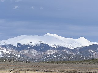
Mummy Mountain is a high mountain summit in the Mummy Range of the Rocky Mountains of North America. The 13,430-foot (4,093 m) thirteener is located in the Rocky Mountain National Park, 8.5 miles (13.7 km) northwest by north of the Town of Estes Park in Larimer County, Colorado, United States.

La Plata Peak is the fifth-highest summit of the Rocky Mountains of North America and the U.S. state of Colorado. The prominent 14,343-foot (4,372 m) fourteener is located in the Collegiate Peaks Wilderness of San Isabel National Forest, 22.7 miles (36.5 km) northwest by west of the Town of Buena Vista in Chaffee County, Colorado, United States.

Mount Lincoln is the eighth-highest summit of the Rocky Mountains of North America and the U.S. state of Colorado. The prominent 14,291-foot (4355.79 m) fourteener is the highest summit of the Mosquito Range and the eleventh-highest summit in the contiguous United States. Mount Lincoln is located in Pike National Forest, 5.2 miles (8.3 km) north-northwest of the Town of Alma in Park County, Colorado, United States. The summit of Mount Lincoln is the highest point in Park County and the entire drainage basin of the Missouri River. The mountain was named in honor of Abraham Lincoln, 16th President of the United States.

Greenhorn Mountain is the highest summit of the Wet Mountains range in the Rocky Mountains of North America. The prominent 12,352-foot (3,765 m) peak is located in the Greenhorn Mountain Wilderness of San Isabel National Forest, 5.2 miles (8.4 km) southwest by west of the Town of Rye, Colorado, United States, on the boundary between Huerfano and Pueblo counties. The summit of Greenhorn Mountain is the highest point in Pueblo County, Colorado. The peak's summit rises above timberline, which is about 11,500 feet (3,500 m) in south-central Colorado.
Culebra Peak is the highest summit of the Culebra Range of the Sangre de Cristo Mountains of the Rocky Mountains of North America. The 14,053-foot (4,283 m) fourteener is located on private land, 14.2 miles (22.8 km) east-southeast of San Luis in Costilla County, Colorado, United States. Culebra Peak is the southernmost fourteener in the range.

Mount Sherman is a high mountain summit in the Mosquito Range of the Rocky Mountains of North America. The 14,043-foot (4,280 m) fourteener is located 6.8 miles (11.0 km) east by south of the City of Leadville, Colorado, United States, on the drainage divide separating Lake County from Park County. The mountain was named in honor of General William Tecumseh Sherman.

Grizzly Peak is a high and prominent mountain summit of the Collegiate Peaks in the Sawatch Range of the Rocky Mountains of North America. The 13,995-foot (4265.6 m) thirteener is located 2.6 miles (4.2 km) south-southwest of Independence Pass, Colorado, United States, on the Continental Divide separating San Isabel National Forest and Chaffee County from White River National Forest and Pitkin County.

Stewart Peak, elevation 13,983 ft (4,262 m), is a summit in Colorado. The peak is the second highest thirteener in the state. It is located in the La Garita Mountains, sub-range of the San Juan Mountains, in Saguache County, within the La Garita Wilderness. Stewart Peak is the 55th highest peak in Colorado by most standard definitions, just missing the list of Colorado fourteeners. At one time, the peak's elevation was measured to be over 14,000 ft and it was believed to be a fourteener, but more recent and accurate surveys have dropped it below that threshold.

Clark Peak is the highest summit of the Medicine Bow Mountains range of the Rocky Mountains of North America. The prominent 12,960-foot (3,950 m) peak is located in the Rawah Wilderness of Routt National Forest, 6.3 miles (10.1 km) north-northwest of Cameron Pass, Colorado, United States, on the drainage divide between Jackson and Larimer counties. Clark Peak is the highest point of Jackson County and the entire drainage basin of the North Platte River.
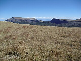
Flat Top Mountain is the highest summit of the Flat Tops in the Rocky Mountains of North America. The prominent 12,361-foot (3,768 m) peak is located in the Flat Tops Wilderness, 19.1 miles (30.7 km) south-southwest of the Town of Oak Creek, Colorado, United States, on the drainage divide between Routt National Forest and White River National Forest. The summit of Flat Top Mountain is the highest point in Garfield County, Colorado.
Mount Zirkel is the highest summit of the Park Range of the Rocky Mountains of North America. The prominent 12,185-foot (3,714 m) peak is located in the Mount Zirkel Wilderness of Routt National Forest, 25.9 miles (41.7 km) north-northeast of the City of Steamboat Springs, Colorado, United States, on the Continental Divide between Jackson and Routt counties. Mount Zirkel was named in honor of German geologist Ferdinand Zirkel.
Crater Peak is the highest summit of Grand Mesa in the Rocky Mountains of North America. The prominent 11,333-foot (3,454 m) peak is located on the drainage divide separating Grand Mesa National Forest and Gunnison National Forest, 12.3 miles (19.8 km) north-northwest of the Town of Paonia in Delta County, Colorado, United States.
South Bald Mountain is the highest summit of the Laramie Mountains in the Rocky Mountains of North America. The summit in Roosevelt National Forest southwest of Red Feather Lakes is the highest of five peaks forming Bald Mountain.

Bald Mountain is a high and prominent mountain summit in the Front Range of the Rocky Mountains of North America. The 13,690-foot (4,173 m) thirteener is located in Arapaho National Forest, 5.5 miles (8.9 km) southeast of the Town of Breckenridge in Summit County, Colorado, United States.
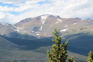
Fairchild Mountain is a high mountain summit in the Mummy Range of the Rocky Mountains of North America. The 13,508-foot (4,117 m) thirteener is located in the Rocky Mountain National Park Wilderness, 9.6 miles (15.5 km) northwest of the Town of Estes Park in Larimer County, Colorado, United States.
South River Peak, elevation 13,154 ft (4,009 m), is a summit in the San Juan Mountains of southwestern Colorado, United States. The mountain is in the Weminuche Wilderness of Rio Grande National Forest.

Mount Powell is the highest summit of the Gore Range in the Rocky Mountains of North America. The prominent 13,586-foot (4,141 m) thirteener is located in the Eagles Nest Wilderness, 8.5 miles (13.7 km) north by east of the Town of Vail, Colorado, United States, along the drainage divide separating White River National Forest and Eagle County from Arapaho National Forest and Summit County. Mount Powell was named in honor of John Wesley Powell who climbed to the summit in 1868.

Bennett Peak is a high and prominent mountain summit in the San Juan Mountains range of the Rocky Mountains System, in southwestern Colorado.
Blair Mountain is the highest summit of the White River Plateau in the Rocky Mountains of North America. The prominent 11,465-foot (3,495 m) peak is located in White River National Forest, 17.5 miles (28.2 km) north by west of the City of Glenwood Springs in Garfield County, Colorado, United States.
California Peak is a high mountain summit in the Sangre de Cristo Range of the Rocky Mountains of North America. The 13,855-foot (4,223 m) thirteener is located on the Sierra Blanca Massif, 12.1 miles (19.5 km) north of the Town of Blanca, Colorado, United States, on the drainage divide separating in Rio Grande National Forest and Alamosa County from San Isabel National Forest and Huerfano County.

