
Needles is a city in eastern San Bernardino County, California, in the Mojave Desert region of Southern California. Situated on the western banks of the Colorado River, Needles is located near the California border with Arizona and Nevada. The city is accessible via Interstate 40 and U.S. Route 95. The population was 4,959 at the 2020 census, up from 4,844 at the 2010 census.

The desert climate or arid climate is a dry climate sub-type in which there is a severe excess of evaporation over precipitation. The typically bald, rocky, or sandy surfaces in desert climates are dry and hold little moisture, quickly evaporating the already little rainfall they receive. Covering 14.2% of Earth's land area, hot deserts are the second-most common type of climate on Earth after the Polar climate.

Roxborough State Park is a state park of Colorado, United States, known for dramatic red sandstone formations. Located in Douglas County 20 miles (32 km) south of Denver, Colorado, the 3,339-acre (13.51 km2) park was established in 1975. In 1980 it was recognized as a National Natural Landmark.
Lake Fork Reservoir is a reservoir located in Wood, Rains, and Hopkins counties in the state of Texas, between the towns of Quitman, Alba, Emory, and Yantis, Texas.

Wilson Lake is a reservoir in the U.S. state of Kansas, on the border of Russell County and Lincoln County. Built and managed by the U.S. Army Corps of Engineers for flood control, it is also used for wildlife management and recreation. Several parks are located along its shoreline, including Wilson State Park.

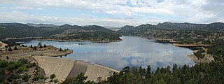
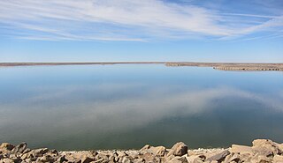
Blue Mesa Reservoir is an artificial reservoir located on the upper reaches of the Gunnison River in Gunnison County, Colorado. The largest lake located entirely within the state, Blue Mesa Reservoir was created by the construction of Blue Mesa Dam, a 390 feet (120 m) tall earthen fill dam constructed on the Gunnison by the U.S. Bureau of Reclamation in 1966 for the generation of hydroelectric power. Managed as part of the Curecanti National Recreation Area, a unit of the National Park Service, Blue Mesa Reservoir is the largest lake trout and Kokanee salmon fishery in Colorado.

Falcon International Reservoir, commonly called Falcon Lake, is a reservoir on the Rio Grande 40 miles (64 km) southeast of Laredo, Texas, United States, and Nuevo Laredo, Tamaulipas, Mexico. The huge lake is bounded by Starr and Zapata Counties on the Texas side of the international border and the municipality and city of Nueva Ciudad Guerrero on the Tamaulipas side. The reservoir was formed by the construction of the Falcon Dam to provide water conservation, irrigation, flood control, and hydroelectricity to the area.
Coleto Creek Reservoir is a reservoir on Coleto Creek and Perdido Creek located in Fannin, Texas, 15 miles (24 km) southwest of Victoria, Texas. The surface of the lake extends into Victoria and Goliad counties. The reservoir was formed in 1980 by the construction of a dam by the Guadalupe-Blanco River Authority to provide a power station cooling pond for electric power generation. Coleto Creek Reservoir is a venue for outdoor recreation, including fishing and boating.

Boysen State Park is a public recreation area surrounding the Boysen Reservoir, an impoundment of the north-flowing Wind River, in Fremont County, Wyoming. The state park covers more than 35,000 acres (14,000 ha) at the south end of the Owl Creek Mountains at the mouth of the Wind River Canyon.

Rio Grande National Forest is a 1.86 million-acre (7,530 km2) U.S. National Forest located in southwestern Colorado. The forest encompasses the San Luis Valley, which is the world's largest agricultural alpine valley, as well as one of the world's largest high deserts located around mountains. The Rio Grande rises in the forest, and the Continental Divide runs along most of its western border. The forest lies in parts of nine counties. In descending order of land area within the forest they are Saguache, Mineral, Conejos, Rio Grande, Hinsdale, San Juan, Alamosa, Archuleta, and Custer counties. Forest headquarters are currently located in Monte Vista, Colorado, but plan to move to Del Norte. There are local ranger district offices in Del Norte, La Jara, and Saguache.

Alamo Lake State Park is a state park of Arizona, United States, centered on Alamo Lake, a flood control and recreational reservoir. The park is located in western Arizona about 38 miles (61 km) north of Wenden. It is accessed via a paved two-lane road off either U.S. Route 60 to the south or U.S. Route 93 to the east. Owing to its remoteness, the park is often considered one of the "best kept secrets" of the state park system.

The Geography of Oklahoma encompasses terrain and ecosystems ranging from arid plains to subtropical forests and mountains. Oklahoma contains 10 distinct ecological regions, more per square mile than in any other state by a wide margin. It is situated in the Great Plains and U.S. Interior Highlands region near the geographical center of the 48 contiguous states. Usually considered part of the South Central United States, Oklahoma is bounded on the east by Arkansas and Missouri, on the north by Kansas, on the northwest by Colorado, on the far west by New Mexico, and on the south and near-west by Texas.

Kentucky is situated in the Upland South region of the United States. A significant portion of eastern Kentucky is part of Appalachia.

Arizona is a landlocked state situated in the southwestern region of the United States of America. It has a vast and diverse geography famous for its deep canyons, high- and low-elevation deserts, numerous natural rock formations, and volcanic mountain ranges. Arizona shares land borders with Utah to the north, the Mexican state of Sonora to the south, New Mexico to the east, and Nevada to the northwest, as well as water borders with California and the Mexican state of Baja California to the southwest along the Colorado River. Arizona is also one of the Four Corners states and is diagonally adjacent to Colorado.

With a total area of 121,590 square miles (314,900 km2), New Mexico is the fifth-largest state, after Alaska, Texas, California, and Montana. Its eastern border lies along 103°W longitude with the state of Oklahoma, and 2.2 miles west of 103°W longitude with Texas. On the southern border, Texas makes up the eastern two-thirds, while the Mexican states of Chihuahua and Sonora make up the western third, with Chihuahua making up about 90% of that. The western border with Arizona runs along the 109° 03'W longitude. The southwestern corner of the state is known as the Bootheel. The 37°N parallel forms the northern boundary with Colorado. The states of New Mexico, Colorado, Arizona, and Utah come together at the Four Corners in New Mexico's northwestern corner. Its surface water area is about 292 square miles (760 km2).
Antero Reservoir is a reservoir in the US state of Colorado. It was created by the first dam placed on the South Platte River in Park County, central Colorado. It is owned by Denver Water and supplies drinking water to the greater Denver metro region almost 140 miles (230 km) away.
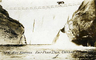
East Park Dam is an agricultural irrigation dam and reservoir built by the United States Bureau of Reclamation, on Little Stony Creek, about 30 miles (48 km) southwest of Orland, California on the northern end of the California Central Valley.
Gross Reservoir, located in Boulder County, Colorado, is owned and operated by Denver Water. Completed in 1954, the reservoir has a surface area of 440 acres (180 ha), and the spillway sits at 7,225 feet (2,202 m) elevation. The reservoir is undergoing an expansion project.
John Martin Reservoir is a reservoir on the Arkansas River in Bent County in southeastern Colorado. Built and managed by the U.S. Army Corps of Engineers, it is used for flood control, irrigation, and recreation. John Martin Reservoir State Park lies on its shore.

Lake Avery is a reservoir in Rio Blanco County, Colorado about 20 miles southeast of the town of Meeker. It also lies west of the unincorporated community of Buford. The reservoir is owned by Colorado Parks and Wildlife, and its dam impounds Big Beaver Creek, a tributary of the White River. Lake Avery is also called Big Beaver Reservoir, however it is unclear whether the name has changed or whether the reservoir just has two names.

