
The San Juan Mountains is a high and rugged mountain range in the Rocky Mountains in southwestern Colorado and northwestern New Mexico. The area is highly mineralized and figured in the gold and silver mining industry of early Colorado. Major towns, all old mining camps, include Creede, Lake City, Silverton, Ouray, and Telluride. Large scale mining has ended in the region, although independent prospectors still work claims throughout the range. The last large-scale mines were the Sunnyside Mine near Silverton, which operated until late in the 20th century, and the Idarado Mine on Red Mountain Pass, which closed in the 1970s. Famous old San Juan mines include the Camp Bird and Smuggler Union mines, both located between Telluride and Ouray.

The Colorado Mineral Belt (CMB) is an area of ore deposits from the La Plata Mountains in Southwestern Colorado to near the middle of the state at Boulder, Colorado, and from which over 25 million troy ounces of gold were extracted beginning in 1858. The belt is a "northeast-striking zone defined by: a Proterozoic shear zone system ; a suite of Laramide-aged plutons and related ore deposits ; a major gravity low ; low-crustal velocities; and high heat flow ." Mining districts include:

Leadville is a statutory city that is the county seat, the most populous community, and the only incorporated municipality in Lake County, Colorado, United States. The city population was 2,633 at the 2020 census. It is situated at an elevation of 10,119 feet (3,084 m). Leadville is the highest incorporated city in the United States and is surrounded by two of the tallest peaks in the state.

Lake County is a county located in the U.S. state of Colorado. As of the 2020 census, the population was 7,436. The county seat and the only municipality in the county is Leadville. The highest natural point in Colorado and the entire Rocky Mountains is the summit of Mount Elbert in Lake County at 14,440 feet elevation.
The Colorado Trail is a long-distance trail running for 486 miles (782 km) from the mouth of Waterton Canyon southwest of Denver to Durango in Colorado, United States. Its highest point is 13,271 feet (4,045 m) above sea level, and most of the trail is above 10,000 feet (3,000 m). Despite its high elevation, the trail often dips below the alpine timberline to provide refuge from the exposed, storm-prone regions above.
The Top of the Rockies National Scenic Byway is a National Scenic Byway and Colorado Scenic and Historic Byway located in the high Rocky Mountains of Eagle, Lake, Pitkin, Summit counties, Colorado, United States. The 115-mile (185 km) byway showcases the two highest peaks of the Rocky Mountains: Mount Elbert at elevation 14,440 feet (4,401.2 m) and Mount Massive at elevation 14,428 feet (4,398 m). The byway connects with the Collegiate Peaks Scenic Byway at the junction of Colorado State Highway 82 and U.S. Highway 24.

The Leadville Trail 100 Run is an ultramarathon held annually on rugged trails and dirt roads near Leadville, Colorado, through the heart of the Rocky Mountains. First run in 1983, the race course climbs and descends 15,600 feet (4,800 m), with elevations ranging from 9,200 to 12,620 feet. In most years, fewer than half the starters complete the race within the 30-hour time limit.

The Silver Valley is a region in the northwest United States, in the Coeur d'Alene Mountains in northern Idaho. It is noted for its mining heritage, dating back to the 1880s.

The National Mining Hall of Fame is a museum located in Leadville, Colorado, United States, dedicated to commemorating the work of miners and people who work with natural resources. The museum also participates in efforts to inform the public about the mining industry.

Granite is an unincorporated community with a U.S. Post Office in Chaffee County, Colorado, United States. The zip code of Granite is 81228. According to the 2010 census, the population is 116.
Gold mining in Colorado, a state of the United States, has been an industry since 1858. It also played a key role in the establishment of the state of Colorado.
Silver mining in Colorado has taken place since the 1860s. In the past, Colorado called itself the Silver State.

Oro City is a ghost town in Lake County, Colorado, United States

The Leadville mining district, located in the Colorado Mineral Belt, was the most productive silver-mining district in the state of Colorado and hosts one of the largest lead-zinc-silver deposits in the world. Oro City, an early Colorado gold placer mining town located about a mile east of Leadville in California Gulch, was the location to one of the richest placer gold strikes in Colorado, with estimated gold production of 120,000–150,000 ozt, worth $2.5 to $3 million at the then-price of $20.67 per troy ounce.

Champion Mill, in Lake County, Colorado, is part of a mining complex on the eastern slope of Mount Champion on Halfmoon Creek. Established in the 1890s, it was a consistent supplier of gold and silver, as well as galena and pyrite to the smelters in Leadville, CO. The mine and mill operated until around 1919, when the price to ship the ore to Leadville became too expensive to maintain a profit. It was briefly reopened between 1937 and 1940, when it finally shut down for good. During its lifespan, the mine produced than 100,000 thousand pounds of minerals.
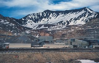
The Climax mine, located in Climax, Colorado, United States, is a major molybdenum mine in Lake and Summit counties, Colorado. Shipments from the mine began in 1915. At its highest output, the Climax mine was the largest molybdenum mine in the world, and for many years it supplied three quarters of the world's supply of molybdenum.

The Henderson molybdenum mine is a large underground molybdenum mine west of the town of Empire in Clear Creek County, Colorado, USA. The Henderson mine, which has produced molybdenum since 1976, is owned by Freeport-McMoRan.

The Golden Fleece Mine is a gold mining site in Hinsdale County, Colorado, 5 miles (8 km) south of Lake City. The mine is located half a mile west of the north end of Lake San Cristobal. By 1904 it had produced $1,400,000 in silver and gold ore. The mine operated intermittently until 1919. Later, in the mid-1960s, some renewed interest in the property came up, especially in the Hiwassee lode area of the mine, but other than a couple of small test shipments, there is no recorded production until today.
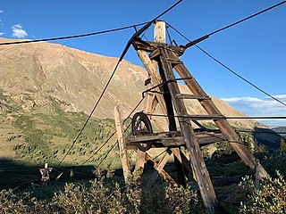
The North London Mill is a gold mill in Park County, Colorado that commenced operations in 1883. In 1874, the first London mine was opened, named for the mountain it burrowed into. The London mines became some of the most productive mines of gold, silver and lead in the area. Between 1879 and 1889, some $82,000,000 of silver was processed in the Leadville area during the Colorado Silver Boom. Due to the rugged environment and high altitude, transportation of ore between the mines and mill was difficult and costly. Thus, the first rope cable-way in Colorado was built to carry ore down the thousand-vertical-foot slope from the mine to the mill. The mine was owned by William K. Jewett of New York and Colorado Springs.
