Chatfield State Park

Last updated
Chatfield State Park
Chatfield State Park.JPG
USA Colorado location map.svg
Red pog.svg
Location Douglas / Jefferson counties, Colorado, United States
Nearest city Littleton, Colorado
Coordinates 39°32′12″N105°04′10″W / 39.5366549°N 105.0694299°W / 39.5366549; -105.0694299 [1] Coordinates: 39°32′12″N105°04′10″W / 39.5366549°N 105.0694299°W / 39.5366549; -105.0694299 [1]
Area3,895 acres (15.76 km2)
Established1975
Governing body Colorado Parks and Wildlife
cpw.state.co.us/placestogo/parks/Chatfield

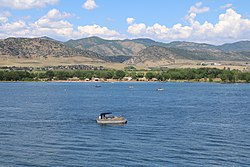
Chatfield State Park is a state park located in Douglas and Jefferson counties of Colorado, United States. The park centers on Chatfield Reservoir, a 1,423 acre surface area lake fed by the South Platte River and two other creeks, including Plum Creek. [2]

Contents

Reservoir Expansion Project

Chatfield Swim Beach Chatfield Reservoir looking east from Chatfield Swim Beach.jpeg
Chatfield Swim Beach

The Chatfield Reservoir Reallocation Project, a US$171 million construction project that took place between 2017 and 2020, created an additional 20,600 acre-feet (25,400,000 cubic meters) of water storage in the reservoir, raising its level by about 12 feet (3.7 meters). The project involved moving some of the surrounding park's facilities back from the new, higher lake levels. [3] [4] [5]

Wildlife

Over three hundred bird species both migrant and resident frequent Chatfield. Also a variety of mammals roam the park, including whitetail and mule deer, coyote, red fox, cottontail rabbit, prairie dogs and weasels.

Audubon Center at Chatfield State Park

View of the park from the Chatfield Overlook Chatfield Reservoir from Chatfield Overlook.jpeg
View of the park from the Chatfield Overlook

The Audubon Society of Greater Denver operates the Audubon Center at Chatfield State Park, a nature education center that offers classes, workshops and lectures for all ages, with an emphasis on children and families.

The center's facilities were originally part of a 5,000-acre (20 km2) ranch for the Atchison family that became the headquarters for the Glenn L. Martin Company in 1955. The land became part of the Chatfield Dam construction project after a flood in 1965, and later became Chatfield State Park. The Audubon Society of Greater Denver was invited by Colorado State Parks to develop a nature center in 1998 out of the old 1940s ranch buildings. In 2004 the Society completed the renovation of the stone garage building into an outdoor learning lab. In 2006 the stone farmhouse was rehabilitated for classroom space and an outdoor amphitheater was constructed. The Society is building a visitor center that will house natural history exhibits, a nature library, an auditorium and a nature-based preschool.

Related Research Articles

<span class="mw-page-title-main">South Platte River</span> River in Colorado and Nebraska, United States

The South Platte River is one of the two principal tributaries of the Platte River. Flowing through the U.S. states of Colorado and Nebraska, it is itself a major river of the American Midwest and the American Southwest/Mountain West. Its drainage basin includes much of the eastern flank of the Rocky Mountains in Colorado, much of the populated region known as the Colorado Front Range and Eastern Plains, and a portion of southeastern Wyoming in the vicinity of the city of Cheyenne. It joins the North Platte River in western Nebraska to form the Platte, which then flows across Nebraska to the Missouri. The river serves as the principal source of water for eastern Colorado. In its valley along the foothills in Colorado, it has permitted agriculture in an area of the Colorado Piedmont and Great Plains that is otherwise arid.

<span class="mw-page-title-main">Douglas County, Colorado</span> County in Colorado, United States

Douglas County is a county located in the U.S. state of Colorado. As of the 2020 census, the population was 357,978. The county seat is Castle Rock.

<span class="mw-page-title-main">Jefferson County, Colorado</span> County in Colorado, United States

Jefferson County is a county located in the U.S. state of Colorado. As of the 2020 census, the population was 582,910, making it the fourth-most populous county in Colorado. The county seat is Golden, and the most populous city is Lakewood.

<span class="mw-page-title-main">Aurora, Colorado</span> City in Colorado, United States

Aurora is a home rule municipality located in Arapahoe, Adams, and Douglas counties, Colorado, United States. The city's population was 386,261 at the 2020 United States Census with 336,035 residing in Arapahoe County, 47,720 residing in Adams County, and 2,506 residing in Douglas County. Aurora is the third most populous city in the State of Colorado and the 51st most populous city in the United States. Aurora is a principal city of the Denver–Aurora–Lakewood Metropolitan Statistical Area (MSA) and a major city of the Front Range Urban Corridor.

<span class="mw-page-title-main">Evergreen, Colorado</span> Census Designated Place in Colorado, United States

Evergreen is an unincorporated town, a post office, and a census-designated place (CDP) located in and governed by Jefferson County, Colorado, U.S. The CDP is a part of the Denver–Aurora–Lakewood, CO Metropolitan Statistical Area. The Evergreen post office has the ZIP Codes 80439 and 80437. At the United States Census 2020, the population of the Evergreen CDP was 9,307. The Evergreen Metropolitan District provides services.

<span class="mw-page-title-main">Curecanti National Recreation Area</span>

Curecanti National Recreation Area(Pronounced or .) is a National Park Service unit located on the Gunnison River in western Colorado. Established in 1965, Curecanti National Recreation Area is responsible for developing and managing recreational facilities on three reservoirs, Blue Mesa Reservoir, Morrow Point Reservoir and Crystal Reservoir, constructed on the upper Gunnison River in the 1960s by the U.S. Bureau of Reclamation to better utilize the vital waters of the Colorado River and its major tributaries. A popular destination for boating and fishing, Curecanti offers visitors two marinas, traditional and group campgrounds, hiking trails, boat launches, and boat-in campsites. The state's premiere lake trout and Kokanee salmon fisheries, Curecanti is a popular destination for boating and fishing, and is also a popular area for ice-fishing in the winter months.

<span class="mw-page-title-main">Colorado–Big Thompson Project</span> Federal water diversion project

The Colorado–Big Thompson Project is a federal water diversion project in Colorado designed to collect West Slope mountain water from the headwaters of the Colorado River and divert it to Colorado's Front Range and plains. In Colorado, approximately 80% of the state's precipitation falls on the West Slope, in the Rocky Mountains, while around 80% of the state's growing population lives along the eastern slope, between the cities of Fort Collins and Pueblo.

<span class="mw-page-title-main">Dillon Reservoir</span> Fresh water reservoir in Summit County, Col., US

Dillon Reservoir, sometimes referred to as Lake Dillon, is a large fresh water reservoir located in Summit County, Colorado, United States, south of I-70 and bordered by the towns of Frisco, Silverthorne, and Dillon. It is a reservoir for the city of Denver, and its waters are under the control of Denver Water. Popular ski areas are close to the reservoir, including Copper Mountain, Keystone, Arapahoe Basin, and Breckenridge.

<span class="mw-page-title-main">Rueter–Hess Reservoir</span> Body of water

The Rueter–Hess Reservoir, behind the Frank Jaeger Dam, is a major water management project for the Parker Water and Sanitation District PWSD. PWSD provides services for most of Parker and parts of Lone Tree, Castle Pines, and unincorporated Douglas County, Colorado. Originally an enterprise of the Town of Parker, PWSD is now an unaffiliated special District.

<span class="mw-page-title-main">Chatfield Reservoir</span> Body of water

Chatfield Dam and Reservoir is a dam and artificial lake located on the South Platte River, south of Littleton, Colorado. The dam and reservoir were built by the United States Army Corps of Engineers as a response to the disastrous flood of 1965. In addition to its primary purpose of flood control, it serves as one of many water supply reservoirs for the city of Denver, Colorado. In 1966, the U.S. Atomic Energy Commission projected a total federal cost of $74 million. Construction of the project was begun in 1967 and the dam was completed in 1975.

The Denver Federal Center, in Lakewood, Colorado, is part of the General Services Administration and is home to about 6,200 employees of agencies of the federal government of the United States. The Center encompasses an area of about 670 acres (2.7 km2) and has 90 buildings with over 4,000,000 square feet (400,000 m2) of office, warehouse, lab and special use space. There are 28 different Federal agencies on-site, making it the largest concentration of Federal agencies outside of Washington, D.C.

The Central Utah Project is a US federal water project that was authorized for construction under the Colorado River Storage Project Act of April 11, 1956, as a participating project. In general, the Central Utah Project develops a portion of Utah's share of the yield of the Colorado River, as set out in the Colorado River Compact of 1922.

<span class="mw-page-title-main">Geography of Colorado Springs, Colorado</span>

Colorado Springs geography describes geographical topics regarding the city of Colorado Springs, Colorado in El Paso County, Colorado. With 194.87 sq mi (504.7 km2) of land, it is the state's largest-sized city. Denver is the most populated city.

<span class="mw-page-title-main">Scofield Reservoir</span> Body of water

Scofield Reservoir is a 2,815-acre (11.39 km2) reservoir impounded by Scofield Dam, in Carbon County, Utah. Located on the Price River, a tributary of the Green River, Scofield Reservoir is adjacent to the northernmost boundary of the Manti–La Sal National Forest. The reservoir sits at an elevation of 7,618 feet (2,322 m), on the northern edge of the Wasatch Plateau. Utah State Route 96 runs along the western shoreline.

<span class="mw-page-title-main">Sterling Ranch, Colorado</span> Census Designated Place in Colorado, United States

Sterling Ranch is an unincorporated community and a census-designated place (CDP) located in and governed by Douglas County, Colorado, United States. The CDP is a part of the Denver–Aurora–Lakewood, CO Metropolitan Statistical Area. Douglas County governs the unincorporated community and the Sterling Ranch Community Authority Board provides services through several metropolitan districts. The Littleton post office serves the area.

<span class="mw-page-title-main">Cherry Creek Dam</span>

Cherry Creek Dam is a dam in Arapahoe County, Colorado southeast of Denver.

<span class="mw-page-title-main">Hildebrand Ranch</span> United States historic place

Hildebrand Ranch is located near Littleton, Colorado. In 1866 Frank and Elizabeth Hildebrand settled in Deer Creek and homesteaded on 160 acres. In the 1950s there was a plan that was authorized to control flooding in Denver but the funds never came. In 1971 the Army condemned 333.73 acres of the ranch and created Chatfield Reservoir. In March 1973 Denver leased 750 acres from Chatfield and 67 for the Denver Botanic Gardens which included the ranch's original buildings. In February 2001 Jefferson County Open Space purchased 1,450 acres of Hildebrand Ranch

<span class="mw-page-title-main">Gross Reservoir</span> Body of water

Gross Reservoir, located in Boulder County, Colorado, is owned and operated by Denver Water. Completed in 1954, the reservoir has a surface area of 440 acres, and the spillway sits at 7,225 feet elevation.

<span class="mw-page-title-main">Plum Creek (Douglas County, Colorado)</span> River in Colorado, United States

Plum Creek is a stream in Douglas County, Colorado. It is formed by the confluence of West Plum Creek and East Plum Creek near the intersection of North Perry Park Road and Manhart Avenue in Sedalia.

Bear Creek Dam is a dam on the confluence of Bear Creek and Turkey Creek within the city limits of Lakewood, Colorado, constructed and operated by the U.S. Army Corps of Engineers for flood control to the greater Denver Metropolitan Area.

References

  1. 1 2 "Chatfield State Park". Geographic Names Information System . United States Geological Survey, United States Department of the Interior . Retrieved 2012-12-04.
  2. "Chatfield State Park [fact sheet] FY09-10" (PDF). Colorado State Parks. Retrieved 2017-07-19.
  3. "State and Federal Partners Finalize Chatfield Reservoir Reallocation Project with Environmental, Agricultural, Recreational Benefits". Colorado Water Conservation Board. Colorado Department of Natural Resources. 2020-05-13. Retrieved 2021-08-05.
  4. Rubino, Joe (2017-06-27). "Chatfield Reservoir expansion project will start this fall". The Denver Post. Retrieved 2017-07-19.
  5. "Project Overview". Chatfield Storage Reallocation Project. Retrieved 2017-07-19.