| Pawnee National Grassland | |
|---|---|
 The Pawnee Buttes in Pawnee National Grassland | |
 Pawnee National Grassland | |
| Location | Weld County, Colorado, United States |
| Nearest city | Greeley, Colorado |
| Coordinates | 40°48′29″N103°59′21″W / 40.80806°N 103.98917°W [1] |
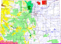
| Area | 193,060 acres (781.3 km2) [2] |
| Established | 1960 |
| Governing body | U.S. Forest Service |
| Website | Arapaho & Roosevelt National Forests and Pawnee National Grassland |
Pawnee National Grassland is a United States National Grassland located in northeastern Colorado on the Colorado Eastern Plains. The grassland is located in the South Platte River basin in remote northern and extreme northeastern Weld County between Greeley and Sterling. It comprises two parcels totaling 193,060 acres (78,130 ha) largely between State Highway 14 and the Wyoming border. The larger eastern parcel lies adjacent to the borders of both Nebraska and Wyoming. It is administered in conjunction with the Arapaho-Roosevelt National Forest from the U.S. Forest Service office in Fort Collins, with a local ranger district office in Greeley. [3]
Contents
- Recreation and access
- Geology
- Shortgrass prairie
- Vegetative zones
- Flora
- Gallery
- See also
- References
- External links
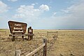
The grassland is in an especially depopulated area of the Great Plains. It saw limited cultivation in the early 20th century but was withdrawn from farming after the Dust Bowl. The communities of Keota and Purcell are located within the grassland. The town of Grover is located directly between the two large parcels of the grasslands near Crow Creek. Briggsdale sits at the southern end where State Highway 14 and State Highway 392 meet. State Highway 71 traverses the eastern unit north of Stoneham. The eastern unit is drained by Pawnee Creek, a tributary of the South Platte. The western unit is largely drained by Crow Creek.