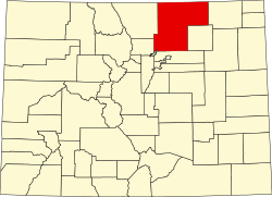
Stoneham, Colorado

Last updated
Stoneham, Colorado
Stoneham, Colorado.JPG
A view of Stoneham and Colorado State Highway 14.
USA Colorado location map.svg
Red pog.svg
Location in Weld County and the state of Colorado
Usa edcp location map.svg
Red pog.svg
Stoneham, Colorado (the United States)
Coordinates: 40°36′17″N103°39′56″W / 40.60472°N 103.66556°W / 40.60472; -103.66556 Coordinates: 40°36′17″N103°39′56″W / 40.60472°N 103.66556°W / 40.60472; -103.66556
Country Flag of the United States.svg  United States
State Flag of Colorado.svg  Colorado
County Weld County [1]
Elevation
[1]
4,583 ft (1,397 m)
Population
 (2020)
  Total20
Time zone UTC-7 (MST)
  Summer (DST) UTC-6 (MDT)
ZIP code [2]
80754
Area code(s) 970
GNIS feature ID 0182781

Stoneham is an unincorporated community and a U.S. Post Office located in Weld County, Colorado, United States. The Stoneham Post Office has the ZIP Code 80754, [2] and has been in operation since 1907. [3]

Contents

Stoneham is approximately 24 miles west of Sterling, 24 miles north of Brush, 43 miles south of Kimball, and 56 miles northeast of Greeley.

History

The Chicago, Burlington, and Quincy Railroad built a rail line from Holdrege to Cheyenne in 1887, passing through the future Stoneham. [4] Stoneham was established in 1888, although a drought strained the town's resources, and forced the closure of the post office from 1892 to 1907.

During the days of CB&Q passenger service, Stoneham was served by the 159 and 160 trains between Sterling and Cheyenne. By train in 1951, Stoneham was 4 hours and 10 minutes away from Cheyenne on the 159 train, and 103 minutes away from Sterling on the 160 train. [5] Passenger service to Stoneham was terminated in 1971 due to the creation of Amtrak, and the termination of many CB&Q passenger routes as a result.

The railway, now owned by the Burlington Northern, was abandoned and torn up by 1983, leaving Stoneham without any rail access. [6]

Geography

Stoneham is located at 40°36′17″N103°39′56″W / 40.60472°N 103.66556°W / 40.60472; -103.66556 (40.604830,-103.665447).

The community is located near the junction of Colorado 71.svg SH 71, heading between La Junta and the Nebraska border, and Colorado 14.svg SH 14, heading between Muddy Pass and Sterling.

Related Research Articles

Sterling, Colorado City in Colorado, United States

Sterling is the home rule municipality that is the county seat and the most populous municipality of Logan County, Colorado, United States. Sterling is the principal city of the Sterling, CO Micropolitan Statistical Area. The city population was 14,777 at the 2010 census.

Raymer, Colorado Town in Colorado, United States

The Town of Raymer is a Statutory Town located in Weld County, Colorado, United States. The population was 96 at the U.S. Census 2010.

Burlington Northern Railroad Former American railroad company

The Burlington Northern Railroad was a United States-based railroad company formed from a merger of four major U.S. railroads. Burlington Northern operated between 1970 and 1996.

Chicago, Burlington and Quincy Railroad Former railroad in the Midwestern United States

The Chicago, Burlington and Quincy Railroad was a railroad that operated in the Midwestern United States. Commonly referred to as the Burlington Route, the Burlington, or as the Q, it operated extensive trackage in the states of Colorado, Illinois, Iowa, Missouri, Nebraska, Wisconsin, Wyoming, and also in Texas through subsidiaries Colorado and Southern Railway, Fort Worth and Denver Railway, and Burlington-Rock Island Railroad. Its primary connections included Chicago, Minneapolis–Saint Paul, St. Louis, Kansas City, and Denver. Because of this extensive trackage in the midwest and mountain states, the railroad used the advertising slogans "Everywhere West", "Way of the Zephyrs", and "The Way West".

Saint Paul Union Depot Train station in Saint Paul, Minnesota

Saint Paul Union Depot is a historic railroad station and intermodal transit hub in the Lowertown neighborhood of the city of Saint Paul, Minnesota, United States. It serves light rail, intercity rail, intercity bus, and local bus services.

The Kansas Pacific Railway (KP) was a historic railroad company that operated in the western United States in the late 19th century. It was a federally chartered railroad, backed with government land grants. At a time when the first transcontinental railroad was being constructed by the Central Pacific and the Union Pacific, it tried and failed to join the transcontinental ranks. It was originally the "Union Pacific, Eastern Division", although it was completely independent. The Pennsylvania Railroad, working with Missouri financiers, designed it as a feeder line to the transcontinental system. The owners lobbied heavily in Washington for money to build a railroad from Kansas City to Colorado, and then to California. It failed to get funding to go west of Colorado. It operated many of the first long-distance lines in the state of Kansas in the 1870s, extending the national railway network westward across that state and into Colorado. Its main line furnished a principal transportation route that opened up settlement of the central Great Plains, and its link from Kansas City to Denver provided the last link in the coast-to-coast railway network in 1870. The railroad was consolidated with the Union Pacific in 1880, and its mainline continues to be an integral part of the Union Pacific network today.

BNSF Line Commuter rail service in the Chicago area

The BNSF Line is a Metra commuter rail line operated by the BNSF Railway in Chicago and its western suburbs. In 2010, the BNSF Line continued to have the highest weekday ridership of the 11 Metra lines. While Metra does not refer to its lines by particular colors, the BNSF line's color on Metra timetables is "Cascade Green," in honor of the Burlington Northern Railroad.

<i>Denver Zephyr</i>

The Denver Zephyr was a streamlined passenger train operated by the Chicago, Burlington and Quincy Railroad between Chicago, Illinois, and Denver, Colorado. In peak years it ran to Colorado Springs. It operated from 1936 to 1973. The Denver Zephyr continued operating after the Burlington Northern Railroad merger in 1970. BN conveyed the train to Amtrak in 1971; Amtrak merged it with the Denver–Oakland City of San Francisco to form the San Francisco Zephyr and dropped the "Denver" name in 1973.

Keota, Colorado Place in Colorado, USA

Keota is a mostly abandoned town located on the prairie in the Pawnee National Grasslands in Weld County in the U.S. state of Colorado.

Black Hills Central Railroad

The Black Hills Central Railroad is a heritage railroad that operates in Keystone, South Dakota, United States. The railroad was added to the National Register of Historic Places on February 5, 2003.

Bond, Colorado Unincorporated community in State of Colorado, United States

Bond is an unincorporated community and U.S. Post Office in Eagle County, Colorado, United States. The Bond Post Office has the ZIP Code 80423. Although Bond has never had a sizable population, the town has significant railroad history, and once was a stop for most of the passenger trains along the Denver and Rio Grande Western's main line.

The Deadwood Central Railroad (DCRX) was a 3 ft narrow gauge railroad in the U.S. state of South Dakota. It was founded by Deadwood, South Dakota resident J.K.P. Miller and his associates in 1888 to serve their mining enterprises in the Black Hills. In 1928, the railroad stretched for a total length of 15.781 miles (25.397 km).

The Burlington-Rock Island Railroad came into existence on July 7, 1930, through the reorganization of its predecessor, the Trinity and Brazos Valley Railway Company (T&BV), nicknamed the "Boll Weevil Line."

Ottumwa station

Ottumwa station is an Amtrak intercity train station in Ottumwa, Iowa, United States. The station was originally built by the Chicago, Burlington and Quincy Railroad, and has been listed as Burlington Depot by the National Register of Historic Places since November 26, 2008. It became a contributing property in the Historic Railroad District in 2011.

The St. Croix Subdivision or St. Croix Sub is an American rail line operated by the BNSF Railway. It runs approximately 150 miles (240 km) from La Crosse, Wisconsin to Saint Paul, Minnesota, following the Mississippi River. It runs through the communities of La Crosse, Onalaska, Brice Prairie, Trempealeau, East Winona, Fountain City, Cochrane, Buffalo City, Alma, Nelson, Pepin, Stockholm, Maiden Rock, Bay City, Diamond Bluff, and Prescott, Wisconsin. This section of track sees 55-60 trains a day and is double tracked for most of the 150 miles with exceptions of Burns to Prescott, Mears to Trevino, and Winona Jct. to East Winona.

Aroya, Colorado Unincorporated community in Colorado, United States

Aroya is a small, rural, unincorporated community in Cheyenne County, Colorado, United States at the eastern end of State Highway 94 near its junction with U.S. Highway 40/U.S. Highway 287. The name Arroyo appears on some older maps. The town was named "Aroya" because of a gulch nearby. The gulch is now named the Aroya Gulch. Aroya originated in 1870 three miles west of the present site as a camp for Kansas-Pacific Railroad track-layers, but was moved to the present site because there was a better supply of water.

The Cameron connector is a section of track built in 1995–1996 which connects the former Burlington Northern Railroad and the former Atchison, Topeka and Santa Fe Railway tracks, both which are now part of the BNSF Railway, to each other near Cameron, Illinois.

<i>California Zephyr</i> Amtrak service between Chicago and the San Francisco Bay Area

The California Zephyr is a passenger train operated by Amtrak between Chicago and the San Francisco Bay Area, via Omaha, Denver, Salt Lake City, and Reno. At 2,438 miles (3,924 km), it is Amtrak's longest daily route, and second-longest overall after the Texas Eagle's triweekly continuation from San Antonio to Los Angeles, with travel time between the termini taking approximately 5112 hours. Amtrak claims the route as one of its most scenic, with views of the upper Colorado River valley in the Rocky Mountains, and the Sierra Nevada. The modern train is the second iteration of a train named California Zephyr; the original train was privately operated and ran on a different route through Nevada and California.

Chicago, Burlington and Quincy 4000 Preserved American CB&Q S-4a class 4-6-4 locomotive

Chicago, Burlington and Quincy No. 4000, also known as Æolus, is a preserved S-4a class 4-6-4 "Hudson" steam locomotive that was originally built by Baldwin in 1930 as S-4 locomotive No. 3002. It was primarily used to pull fast passenger trains before it was rebuilt by the Chicago, Burlington and Quincy Railroad in 1937 to be re-classified as an S-4a with Streamlining, and it was renumbered 4000 in the process. The streamlining was removed during World War II, and the locomotive was later downgraded to secondary passenger and mail service. In 1956, No. 4000 pulled an excursion train between Galesburg and Aurora, Illinois for the Illinois Railroad Club before it was retired altogether. The locomotive was donated to the city of La Crosse, Wisconsin in 1963, and it remains on static display in Copeland Park, as of 2022.

Sligo is a ghost town in Weld County, in the U.S. state of Colorado.

References

  1. 1 2 "US Board on Geographic Names". United States Geological Survey. 2007-10-25. Retrieved 2008-01-31.
  2. 1 2 "ZIP Code Lookup" (JavaScript/HTML). United States Postal Service. January 3, 2007. Retrieved January 3, 2007.
  3. "Jim Forte Postal History" . Retrieved July 1, 2022.
  4. Fraser, Clayton, B. (August 31, 1997), The History and Evolution of Colorado's Railroads: 1858-1948 (PDF), Loveland: United States Department of the Interior, p. 54
  5. "Burlington Railroad (CB&Q): Map, History, Timetable, Photos". American Rails. Retrieved July 1, 2022.
  6. United States Geological Survey (1983). TopoView - Sterling, Colorado (Map). United States Department of the Interior. Retrieved July 1, 2022.