Milliken, Colorado

Last updated

Town of Milliken, Colorado
Milliken, Colorado.JPG
Broad Street in Milliken.
Nickname: 
The hub of northern Colorado
Weld County Colorado Incorporated and Unincorporated areas Milliken Highlighted 0850480.svg
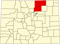
Location of Milliken in Weld County, Colorado.
Coordinates: 40°19′52″N104°51′36″W / 40.33111°N 104.86000°W / 40.33111; -104.86000
Country Flag of the United States (23px).png  United States
State Flag of Colorado.svg Colorado
County [1] Weld
Incorporated (town) October 1, 1910 [2]
Government
  Type Statutory Town [1]
   Mayor Elizabeth Austin
Area
[3]
  Total
12.90 sq mi (33.41 km2)
  Land12.81 sq mi (33.19 km2)
  Water0.09 sq mi (0.22 km2)
Elevation
[4]
4,751 ft (1,448 m)
Population
 (2020) [5]
  Total
8,386
  Density650/sq mi (250/km2)
Time zone UTC-7 (Mountain (MST))
  Summer (DST) UTC-6 (MDT)
ZIP code [6]
80543
Area code 970
FIPS code 08-50480
GNIS feature ID 0180708
Website Town of Milliken

Milliken is a statutory town in Weld County, Colorado, United States. The town population was 8,386 at the 2020 United States census. [5]

Contents

History

The town was named for John D. Milliken, a Judge.

The first community located near the Milliken townsite was initially known as Hillsboro. The community began as a trading post on the Denver, Laramie, and Northwestern Railroad for agricultural goods in the 1860s. By 1908 the town of Milliken had grown up nearby Hillsboro, and in 1910 Hillsboro was annexed by Milliken.

Fires in the 1910s destroyed much of the town, and in 1917 the Denver, Laramie, and Northwestern Railroad was abandoned.

Milliken continued as a primarily farming community through the depression and world wars. In the 1950s two large potato decks were constructed. The late 1960s and early 1970s brought a housing boom.

In 1985 and 1986 the town roads were paved. The town continued to grow, causing the town government to move its facilities, in 1996, into the Milliken Community Complex. Additional facilities were added, including the Milliken Public Work Facility in 2004, and a new police station in 2009. [7]

Geography

Milliken is located at 40°19′52″N104°51′36″W / 40.33111°N 104.86000°W / 40.33111; -104.86000 (40.331073, -104.859878). [8]

According to the United States Census Bureau, the town has a total area of 5.7 square miles (15 km2), all of it land.

Demographics

Historical population
CensusPop.Note
1920 372
1930 48329.8%
1940 5319.9%
1950 510−4.0%
1960 63023.5%
1970 70211.4%
1980 1,506114.5%
1990 1,6056.6%
2000 2,88879.9%
2010 5,61094.3%
2020 8,38649.5%
2023 (est.)9,084 [9] 8.3%

Education

Milliken is served by the Weld Re-5J School District. Children in the town attend Milliken Elementary School, Knowledge Quest Academy (KQA) and Civica. Roosevelt Middle School (Formally known as Milliken Middle school from 1969-2024) and Roosevelt High School Are both located in nearby Johnstown. And in the 2025-26 school year 3rd through 5th graders will attend the former Milliken Middle School renamed and repurposed into Milliken Intermediate School [10] .

Daniels School

The Daniels School, in Milliken in Weld County, Colorado, was built in 1911. It is a two-room schoolhouse, with a partition that allowed separation of grades 1–4 vs. grades 5–8, which operated from 1911 to 1959. [11] It was listed on the National Register of Historic Places in 2005. [12] It was built on a one-acre (0.40 ha) plot of land donated to the school district by James Daniels in 1879. A wood-frame schoolhouse was built first; it was sold and moved off the property to enable replacement by the present brick building in 1911. James Daniels served as director of the school for many years. The school was named, however, for his brother, Henry Daniels, who was a pioneer in the Big Thompson Valley area before Johnstown and Milliken existed. [13] But Daniels school is just one of the many historic buildings around Milliken.

See also

References

  1. 1 2 "Active Colorado Municipalities". State of Colorado, Department of Local Affairs. Archived from the original on December 12, 2009. Retrieved September 1, 2007.
  2. "Colorado Municipal Incorporations". State of Colorado, Department of Personnel & Administration, Colorado State Archives. December 1, 2004. Archived from the original on August 23, 2003. Retrieved September 2, 2007.
  3. "2019 U.S. Gazetteer Files". Census.gov . United States Census Bureau. Retrieved July 1, 2020.
  4. "US Board on Geographic Names". United States Geological Survey. October 25, 2007. Retrieved January 31, 2008.
  5. 1 2 United States Census Bureau. "Milliken town, Colorado" . Retrieved April 19, 2023.
  6. "ZIP Code Lookup". USPS.com. United States Postal Service. Archived from the original (JavaScript/HTML) on January 1, 2008. Retrieved November 22, 2007.
  7. "History of Milliken" . Retrieved May 10, 2015.
  8. "US Gazetteer files: 2010, 2000, and 1990". United States Census Bureau. February 12, 2011. Retrieved April 23, 2011.
  9. "Annual Estimates of the Resident Population for Counties: April 1, 2020 to July 1, 2023". United States Census Bureau. Retrieved March 24, 2024.
  10. https://www.weldre5j.org/
  11. https://npgallery.nps.gov/NRHP/GetAsset/NRHP/05000653_text
  12. https://npgallery.nps.gov/NRHP
  13. https://npgallery.nps.gov/NRHP/GetAsset/NRHP/05000653_text