Masters, Colorado

Last updated

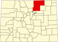
Masters is an extinct town in Weld County, in the U.S. state of Colorado. The GNIS classifies it as a populated place. [1]

History

A post office called Masters was established in 1900, and remained in operation until 1967. [2] The community was named for a local rancher, who owned the land the town was built on. [3]

Masters was located on a rail line from LaSalle to Julesburg, which was built by the Colorado Central Railroad. [4] A siding was built to the north of the post office, near the banks of the South Platte River. [5] The rail line was abandoned by the Union Pacific Railroad in the 1990s. [6]

Related Research Articles

<span class="mw-page-title-main">Ramah, Colorado</span> Town in Colorado, United States

The town of Ramah is a Statutory Town in El Paso County, Colorado, United States. The population was 123 as of the 2010 census. According to tradition, the name is derived from India.

<span class="mw-page-title-main">Fowler, Colorado</span> Town in Colorado, United States

The Town of Fowler is a statutory town located in northwestern Otero County, Colorado, United States. The town population was 1,253 at the 2020 United States Census.

<span class="mw-page-title-main">Gilcrest, Colorado</span> Town in Colorado, United States

The Town of Gilcrest is a Statutory Town located in Weld County, Colorado, United States. The town population was 1,029 at the 2020 United States Census. Gilcrest is a part of the Greeley, CO Metropolitan Statistical Area and the Front Range Urban Corridor.

<span class="mw-page-title-main">Kersey, Colorado</span> Town in Colorado, United States

The Town of Kersey is a Statutory Town in Weld County, Colorado, United States. The population was 1,454 at the 2010 United States Census.

<span class="mw-page-title-main">LaSalle, Colorado</span> Town in Colorado, United States

The Town of LaSalle is a Statutory Town in Weld County, Colorado, United States. The town population was 1,955 at the 2010 United States Census.

<span class="mw-page-title-main">Mead, Colorado</span> Town in Colorado, United States

The Town of Mead is a Statutory Town in Weld County, Colorado, United States. The town population was 3,405 at the 2010 United States Census.

<span class="mw-page-title-main">Pierce, Colorado</span> Town in Colorado, United States

Pierce is a Statutory Town in Weld County, Colorado, United States. The population was 834 at the 2010 census. The town is a rural agricultural community located on the Colorado Eastern Plains along U.S. Highway 85 north of Greeley.

<span class="mw-page-title-main">Severance, Colorado</span> Town in Colorado, United States

Severance is a Statutory Town in Weld County, Colorado, United States. The population was 7,683 at the 2020 census. The town is located on the Colorado Eastern Plains, northwest of Greeley, a crossroads of county roads.

<span class="mw-page-title-main">Keota, Colorado</span> Place in Colorado, USA

Keota is a mostly abandoned town located on the prairie in the Pawnee National Grasslands in Weld County in the U.S. state of Colorado.

<span class="mw-page-title-main">Sargents, Colorado</span> Unincorporated community in Saguache County, Colorado, United States

Sargents is an unincorporated community and a U.S. Post Office in Saguache County, Colorado, United States. The Sargents Post Office has the ZIP code 81248.

<span class="mw-page-title-main">Stoneham, Colorado</span> Unincorporated community in Colorado, United States

Stoneham is an unincorporated community and a U.S. Post Office located in Weld County, Colorado, United States. The Stoneham Post Office has the ZIP Code 80754, and has been in operation since 1907.

Deora is an unincorporated community in Baca County, Colorado, United States. Deora was once the site of a post office, rail siding, school, and store, but little remains today.

Ogilby is a ghost town in Imperial County, California, United States. Ogilby is located on the Southern Pacific Railroad 42 miles (68 km) east of El Centro, and 3.8 miles (6.1 km) north of Interstate 8 on County Road S34. The name is official for federal use, and a feature ID number of 252950 has been assigned. Ogilby is defined by the US Geological Survey as a populated place at 356 feet (109 m) AMSL elevation. NAD27 latitude and longitude are listed at 32°49′01″N114°50′20″W on the "Ogilby, California" 7.5-minute quadrangle (map). It is included in the Imperial County Air Pollution Control District. It lies at an elevation of 364 feet (111 m).

<span class="mw-page-title-main">Leyner, Colorado</span> Census Designated Place in Colorado, United States

Leyner is an unincorporated community and a census-designated place (CDP) located in and governed by Boulder County, Colorado, United States. The CDP is a part of the Boulder, CO Metropolitan Statistical Area. The population of the Leyner CDP was 29 at the United States Census 2010. The Lafayette post office serves the area.

Cornish is an unincorporated community in Weld County, in the U.S. state of Colorado.

<span class="mw-page-title-main">Doyleville, Colorado</span> Unincorporated community in Colorado, United States

Doyleville is an unincorporated community in Gunnison County, in the U.S. state of Colorado. It is located 19 miles (31 km) east of Gunnison on U.S. Highway 50.

Liggett is an unincorporated community in Boulder County, Colorado, United States. It is to the northwest of Lafayette.

St Vrains is a ghost town in Weld County, in the U.S. state of Colorado.

Sligo is a ghost town in Weld County, in the U.S. state of Colorado.

Dick is a ghost town in Weld County, in the U.S. state of Colorado.

References

  1. U.S. Geological Survey Geographic Names Information System: Masters, Colorado
  2. "Post offices". Jim Forte Postal History. Retrieved 1 July 2016.
  3. Dawson, John Frank. Place names in Colorado: why 700 communities were so named, 150 of Spanish or Indian origin. Denver, CO: The J. Frank Dawson Publishing Co. p. 34.
  4. Fraser, Clayton, B. (August 31, 1997), The History and Evolution of Colorado's Railroads: 1858-1948 (PDF), Loveland: United States Department of the Interior, p. 98
  5. United States Geological Survey (1951). Masters Quadrangle, Colorado (Map). United States Department of the Interior. Retrieved September 9, 2021.
  6. United States Geological Survey (2010). Masters Quadrangle, Colorado (Map). United States Department of the Interior. Retrieved September 9, 2021.

Coordinates: 40°18′34″N104°14′42″W / 40.30944°N 104.24500°W / 40.30944; -104.24500