Briggsdale, Colorado

Last updated

Briggsdale, Colorado
BriggsdaleCOChurch.JPG
A church in Briggsdale.
USA Colorado location map.svg
Red pog.svg
Briggsdale
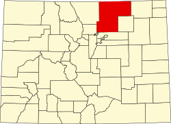
Location of the Briggsdale CDP in the State of Colorado.
Coordinates: 40°38′05″N104°19′37″W / 40.6347°N 104.3269°W / 40.6347; -104.3269 (Briggsdale, Colorado) [1]
Country Flag of the United States.svg  United States
State Flag of Colorado.svg  Colorado
County Weld County
Established1909 [2]
Government
[3]
  Type unincorporated town
Area
[4]
  Total
0.650 sq mi (1.683 km2)
  Land0.650 sq mi (1.683 km2)
  Water0.000 sq mi (0.000 km2)
Elevation
[1]
4,865 ft (1,483 m)
Population
 (2020) [5]
  Total
134
  Density210/sq mi (80/km2)
Time zone UTC-7 (MST)
  Summer (DST) UTC-6 (MDT)
ZIP Code [6]
80611
Area code 970
GNIS feature [3] Briggsdale CDP

Briggsdale is an unincorporated town, a post office, and a census-designated place (CDP) located in and governed by Weld County, Colorado, United States. The CDP is a part of the Greeley, CO Metropolitan Statistical Area. The Briggsdale post office has the ZIP Code 80611. [6] At the United States Census 2020, the population of the Briggsdale CDP was 134. [5]

Contents

History

Briggsdale was established in 1909. [2] The town was named for Frank N. Briggs, a farmer and one of the founders. [2] The Briggsdale, Colorado, post office opened on August 1, 1910. [7]

Geography

Briggsdale is located at coordinates 40°38′05″N104°19′37″W / 40.6347°N 104.3269°W / 40.6347; -104.3269 (Briggsdale, Colorado) . [1]

The Briggsdale CDP has an area of 416 acres (1.683 km2), all land. [4]

Climate

Climate data for Briggsdale, Colorado, 1991–2020 normals, extremes 1963present
MonthJanFebMarAprMayJunJulAugSepOctNovDecYear
Record high °F (°C)71
(22)
74
(23)
81
(27)
89
(32)
96
(36)
102
(39)
106
(41)
103
(39)
99
(37)
89
(32)
78
(26)
75
(24)
106
(41)
Mean maximum °F (°C)61.0
(16.1)
64.5
(18.1)
74.4
(23.6)
80.8
(27.1)
89.6
(32.0)
95.2
(35.1)
99.7
(37.6)
97.4
(36.3)
92.9
(33.8)
83.6
(28.7)
71.9
(22.2)
61.5
(16.4)
100.4
(38.0)
Mean daily maximum °F (°C)41.4
(5.2)
44.3
(6.8)
54.8
(12.7)
62.0
(16.7)
71.3
(21.8)
83.1
(28.4)
90.0
(32.2)
87.1
(30.6)
78.8
(26.0)
64.9
(18.3)
50.8
(10.4)
40.8
(4.9)
64.1
(17.8)
Daily mean °F (°C)25.5
(−3.6)
28.4
(−2.0)
38.1
(3.4)
45.9
(7.7)
56.0
(13.3)
66.7
(19.3)
73.1
(22.8)
70.4
(21.3)
61.2
(16.2)
47.9
(8.8)
34.5
(1.4)
25.1
(−3.8)
47.7
(8.7)
Mean daily minimum °F (°C)9.7
(−12.4)
12.6
(−10.8)
21.4
(−5.9)
29.8
(−1.2)
40.7
(4.8)
50.4
(10.2)
56.2
(13.4)
53.7
(12.1)
43.6
(6.4)
31.0
(−0.6)
18.2
(−7.7)
9.4
(−12.6)
31.4
(−0.4)
Mean minimum °F (°C)−9.6
(−23.1)
−5.9
(−21.1)
4.0
(−15.6)
16.1
(−8.8)
26.8
(−2.9)
38.4
(3.6)
47.4
(8.6)
45.3
(7.4)
30.4
(−0.9)
12.5
(−10.8)
−0.8
(−18.2)
−8.0
(−22.2)
−16.8
(−27.1)
Record low °F (°C)−30
(−34)
−33
(−36)
−20
(−29)
4
(−16)
16
(−9)
20
(−7)
33
(1)
33
(1)
17
(−8)
−18
(−28)
−17
(−27)
−38
(−39)
−38
(−39)
Average precipitation inches (mm)0.15
(3.8)
0.23
(5.8)
0.76
(19)
1.49
(38)
2.08
(53)
2.08
(53)
1.75
(44)
1.98
(50)
1.26
(32)
0.87
(22)
0.43
(11)
0.35
(8.9)
13.43
(340.5)
Average snowfall inches (cm)2.4
(6.1)
2.3
(5.8)
3.8
(9.7)
1.2
(3.0)
0.3
(0.76)
0.0
(0.0)
0.0
(0.0)
0.0
(0.0)
0.1
(0.25)
1.6
(4.1)
2.8
(7.1)
4.3
(11)
18.8
(47.81)
Average precipitation days (≥ 0.01 in)2.02.33.34.88.87.47.07.14.84.43.12.657.6
Average snowy days (≥ 0.1 in)1.41.61.60.80.10.00.00.00.10.81.42.310.1
Source 1: NOAA [8]
Source 2: National Weather Service [9]

Demographics

The United States Census Bureau defined the Briggsdale CDP for the United States Census 2020.

Briggsdale CDP, Colorado
YearPop.±%
2020 134    
Source: United States Census Bureau

See also

Related Research Articles

<span class="mw-page-title-main">Weld County, Colorado</span> County in Colorado, United States

Weld County is a county located in the U.S. state of Colorado. As of the 2020 census, the population was 328,981. The county seat is Greeley.

<span class="mw-page-title-main">Brighton, Colorado</span> City in Colorado, United States

Brighton is a home rule municipality city located in Adams and Weld counties, Colorado, United States. Brighton is the county seat of Adams County and a part of the Denver–Aurora–Lakewood, CO Metropolitan Statistical Area and the Front Range Urban Corridor. The city population was 40,083 at the 2020 United States Census with 39,718 residing in Adams County and 365 residing in Weld County.

<span class="mw-page-title-main">Derby, Colorado</span> Census Designated Place in Colorado, United States

Derby is an unincorporated community and a census-designated place (CDP) located in and governed by Adams County, Colorado, United States. The CDP is a part of the Denver–Aurora–Lakewood, CO Metropolitan Statistical Area. The population of the Derby CDP was 8,407 at the United States Census 2020. The Commerce City post office serves the area.

<span class="mw-page-title-main">Byers, Colorado</span> Census Designated Place in Colorado, United States

Byers is an unincorporated town, a post office, and a census-designated place (CDP) located in and governed by Arapahoe County, Colorado, United States. The CDP is a part of the Denver–Aurora–Lakewood, CO Metropolitan Statistical Area. The Byers post office has the ZIP Code 80103. At the United States Census 2020, the population of the Byers CDP was 1,322.

<span class="mw-page-title-main">Avondale, Colorado</span> Census-designated place in Pueblo County, Colorado, United States

Avondale is a census-designated place (CDP) and post office in and governed by Pueblo County, Colorado, United States. The CDP is a part of the Pueblo, CO Metropolitan Statistical Area. The Avondale post office has the ZIP Code 81022. At the United States Census 2020, the population of the Avondale CDP was 594, while the population of the 81022 ZIP Code Tabulation Area was 1,624 including adjacent areas.

<span class="mw-page-title-main">Aristocrat Ranchettes, Colorado</span> Census Designated Place in Colorado, United States

Aristocrat Ranchettes is an unincorporated community and a census-designated place (CDP) located in and governed by Weld County, Colorado, United States. The population of the Aristocrat Ranchettes CDP was 1,715 at the United States Census 2020. The Fort Lupton post office (Zip Code 80621) serves the area. The CDP is a part of the Greeley, CO Metropolitan Statistical Area.

<span class="mw-page-title-main">Evans, Colorado</span> City in Colorado, United States

The City of Evans is a home rule municipality located in Weld County, Colorado, United States. The city population was 22,165 at the 2020 United States Census, a 19.57% increase since the 2010 United States census. Evans is a part of the Greeley, CO Metropolitan Statistical Area and the Front Range Urban Corridor.

<span class="mw-page-title-main">Garden City, Colorado</span> Town in Colorado, United States

The Town of Garden City is a Statutory Town located in Weld County, Colorado, United States. The town population was 254 at the 2020 United States Census. Garden City is a part of the Greeley, CO Metropolitan Statistical Area and the Front Range Urban Corridor. It is surrounded by the cities of Greeley and Evans, Colorado.

<span class="mw-page-title-main">Gilcrest, Colorado</span> Town in Colorado, United States

The Town of Gilcrest is a Statutory Town located in Weld County, Colorado, United States. The town population was 1,029 at the 2020 United States Census. Gilcrest is a part of the Greeley, CO Metropolitan Statistical Area and the Front Range Urban Corridor.

<span class="mw-page-title-main">Kersey, Colorado</span> Town in Weld County, Colorado, United States

The Town of Kersey is a Statutory Town in Weld County, Colorado, United States. The population was 1,495 at the 2020 United States Census.

<span class="mw-page-title-main">LaSalle, Colorado</span> Town in Colorado, United States

The Town of LaSalle is a Statutory Town in Weld County, Colorado, United States. The town population was 2,359 at the 2020 United States Census.

<span class="mw-page-title-main">Mead, Colorado</span> Town in Colorado, United States

The Town of Mead is a Statutory Town in Weld County, Colorado, United States. The town population was 4,781 at the 2020 United States Census.

<span class="mw-page-title-main">Nunn, Colorado</span> Town in Colorado, United States

Nunn is a Statutory Town in Weld County, Colorado, United States. The population was 504 at the 2020 census.

<span class="mw-page-title-main">Pierce, Colorado</span> Town in Colorado, United States

Pierce is a Statutory Town in Weld County, Colorado, United States. The population was 1,097 at the 2020 census. The town is a rural agricultural community located on the Colorado Eastern Plains along U.S. Highway 85 north of Greeley.

<span class="mw-page-title-main">Raymer, Colorado</span> Town in Colorado, United States

The Town of Raymer is a Statutory Town located in Weld County, Colorado, United States. The population was 110 at the U.S. Census 2020.

<span class="mw-page-title-main">Rollinsville, Colorado</span> Census-designated place in Gilpin County, Colorado, United States

Rollinsville is a census-designated place (CDP) and post office in and governed by Gilpin County, Colorado, United States. The CDP is a part of the Denver–Aurora–Lakewood, CO Metropolitan Statistical Area. The Rollinsville post office has the ZIP Code 80474. At the United States Census 2020, the population of the Rollinsville CDP was 194.

<span class="mw-page-title-main">Amherst, Colorado</span> Census-designated place in Phillips County, Colorado, United States

Amherst is a census-designated place (CDP) and a post office in and governed by Phillips County, Colorado, United States. As of the United States Census 2020, the population of the Amherst CDP was 47.

<span class="mw-page-title-main">Altona, Colorado</span> Census Designated Place in Colorado, United States

Altona is an unincorporated community and a census-designated place (CDP) located in and governed by Boulder County, Colorado, United States. The CDP is a part of the Boulder, CO Metropolitan Statistical Area. The population of the Altona CDP was 512 at the United States Census 2020. The Boulder post office serves the area.

<span class="mw-page-title-main">Crisman, Colorado</span> Census Designated Place in Colorado, United States

Crisman is an unincorporated community and a census-designated place (CDP) located in and governed by Boulder County, Colorado, United States. The CDP is a part of the Boulder, CO Metropolitan Statistical Area. The population of the Crisman CDP was 179 at the United States Census 2020. The Boulder post office serves the area.

<span class="mw-page-title-main">Brook Forest, Colorado</span> Census Designated Place in Colorado, United States

Brook Forest is an unincorporated community and a census-designated place (CDP) located in and governed by Jefferson and Clear Creek counties, Colorado, United States. The population was 622 at the 2020 census. The CDP is a part of the Denver–Aurora–Lakewood, CO Metropolitan Statistical Area. The Evergreen Post Office serves the area.

References

  1. 1 2 3 "Geographic Names Information System". United States Geological Survey, United States Department of the Interior . Retrieved December 26, 2024.
  2. 1 2 3 Eichler, Geo. R. (1977). Colorado Place Names. Johnson Publishing Company.
  3. 1 2 "U.S. Board on Geographic Names: Domestic Names". United States Geological Survey . Retrieved December 27, 2020.
  4. 1 2 "State of Colorado Census Designated Places - BAS20 - Data as of January 1, 2020". United States Census Bureau . Retrieved December 27, 2020.
  5. 1 2 United States Census Bureau. "Briggsdale CDP, Colorado" . Retrieved March 31, 2023.
  6. 1 2 "Look Up a ZIP Code". United States Postal Service . Retrieved December 27, 2020.
  7. Bauer, William H.; Ozment, James L.; Willard, John H. (1990). Colorado Post Offices 1859–1989. Golden, Colorado: Colorado Railroad Historical Foundation. ISBN   0-918654-42-4.
  8. "U.S. Climate Normals Quick Access – Station: Briggsdale, CO". National Oceanic and Atmospheric Administration. Retrieved February 25, 2023.
  9. "NOAA Online Weather Data – NWS Boulder". National Weather Service. Retrieved February 25, 2023.