Archuleta County, Colorado

Last updated

Archuleta County
ArchuletaCountyCourthouseCO.JPG
Archuleta County Courthouse
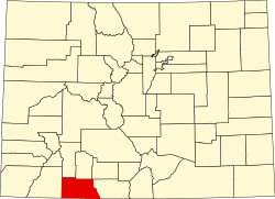
Map of Colorado highlighting Archuleta County.svg
Location within the U.S. state of Colorado
Colorado in United States.svg
Colorado's location within the U.S.
Coordinates: 37°11′N107°03′W / 37.19°N 107.05°W / 37.19; -107.05
CountryFlag of the United States.svg United States
StateFlag of Colorado.svg  Colorado
FoundedApril 14, 1885
Named for Antonio D. Archuleta
Seat Pagosa Springs
Largest townPagosa Springs
Area
  Total1,356 sq mi (3,510 km2)
  Land1,350 sq mi (3,500 km2)
  Water5.3 sq mi (14 km2)  0.4%
Population
 (2020)
  Total13,359
  Density9.9/sq mi (3.8/km2)
Time zone UTC−7 (Mountain)
  Summer (DST) UTC−6 (MDT)
Congressional district 3rd
Website www.archuletacounty.org
Archuleta County Sheriff's Department and Detention Facility in Pagosa Springs ArchuletaCountyPoliceJail.JPG
Archuleta County Sheriff's Department and Detention Facility in Pagosa Springs

Archuleta County is a county located in the U.S. state of Colorado. As of the 2020 census, the population was 13,359. [1] The county seat and the only incorporated municipality in the county is Pagosa Springs. [2]

Contents

History

Archuleta County was created by the Colorado legislature on April 14, 1885, out of western Conejos County. It was named for Jose Manuel Archuleta, "head of one of the old Spanish families of New Mexico", [3] and in honor of his son Antonio D. Archuleta, who was the Senator from Conejos County at the time.

Geography

According to the U.S. Census Bureau, the county has a total area of 1,356 square miles (3,510 km2), of which 1,350 square miles (3,500 km2) is land and 5.3 square miles (14 km2) (0.4%) is water. [4]

Adjacent counties

Airport

Major highways

National protected areas

Historical population
CensusPop.Note
1890 826
1900 2,117156.3%
1910 3,30256.0%
1920 3,5908.7%
1930 3,204−10.8%
1940 3,80618.8%
1950 3,030−20.4%
1960 2,629−13.2%
1970 2,7334.0%
1980 3,66434.1%
1990 5,34545.9%
2000 9,89885.2%
2010 12,08422.1%
2020 13,35910.6%
2023 (est.)14,189 [5] 6.2%
U.S. Decennial Census [6]
1790-1960 [7] 1900-1990 [8]
1990-2000 [9]

State protected area

Scenic and historic trails

Waterways

Demographics

According to the 2020 census, there were 13,359 people, 5,736 households living in the county. The average household size was 2.34 persons. The population density was 9.9 people per square mile (3.8 people/km2). As of 2021, there were 9,693 housing units at an average density of 7.2 per square mile (2.8/km2). The racial makeup of the county was 90.9% White, 0.9% Black or African American, 3.8% Native American, 1.2% Asian, 0.2% Pacific Islander, and 3.1% from two or more races. 18.5% of the population were Hispanic or Latino of any race. [1]

The age distribution was 4.1% under 5 years, 17.5% under 18 years, 51.1% between 18 and 64 years, and 27.3% 65 years or older. 49.9% were female. [1]

The median household income (in 2020 dollars) was $55,658. The per capita income for the county was $32,995. About 9.40% of the population were at or below the poverty line. [1]

Politics

As of January 2022, Archuleta County had approximately 10,696 active registered voters. There were 40.6% unaffiliated with a party, 38.3% Republican, 19.6% Democrat, .8% Libertarian, .2% Green, and .5% various other parties. [12]

Voting in the county tends to favor conservative choices, especially at the state and national level, but winning elections for unaffiliated local candidates are not uncommon. [13]

Archuleta County Commissioner elections, 2010-2022 [13]
RepublicanDemocratUnaffiliated
2022, District 362.30%37.70%
2020, District 150.30%49.70%
2020, District 252.00%48.00%
2018, District 397.20%2.80%
2016, District 148.50%21.80%29.70%
2016, District 256.40%20.70%22.90%
2014, District 346.90%53.10%
2012, District 185.70%14.30%
2012, District 261.90%38.10%
2010, District 342.50%57.50%
United States presidential election results for Archuleta County, Colorado [14]
Year Republican Democratic Third party
No.%No.%No.%
2020 5,18956.75%3,73840.88%2172.37%
2016 4,26458.10%2,50034.06%5757.83%
2012 3,87257.50%2,67939.78%1832.72%
2008 3,63854.91%2,83642.81%1512.28%
2004 3,60161.67%2,14136.67%971.66%
2000 2,98862.80%1,43230.10%3387.10%
1996 1,96357.11%99729.01%47713.88%
1992 1,24244.11%81929.08%75526.81%
1988 1,44063.66%79535.15%271.19%
1984 1,55771.98%58427.00%221.02%
1980 1,25265.89%53228.00%1166.11%
1976 76853.63%63244.13%322.23%
1972 60664.47%30031.91%343.62%
1968 48649.69%40941.82%838.49%
1964 37036.71%63262.70%60.60%
1960 48946.26%56753.64%10.09%
1956 63559.91%42339.91%20.19%
1952 69164.58%37735.23%20.19%
1948 59755.07%47944.19%80.74%
1944 60258.45%42741.46%10.10%
1940 86953.71%74445.98%50.31%
1936 54140.59%76157.09%312.33%
1932 46232.77%92865.82%201.42%
1928 61056.48%44741.39%232.13%
1924 45143.12%26925.72%32631.17%
1920 70063.12%37934.17%302.71%
1916 47335.70%83062.64%221.66%
1912 45228.88%60938.91%50432.20%
1908 50346.06%50546.25%847.69%
1904 67463.71%35733.74%272.55%
1900 57859.40%39140.18%40.41%
1896 14126.26%39373.18%30.56%
1892 10747.98%00.00%11652.02%
1888 12762.25%7737.75%00.00%

Communities

Town

Census-designated place

Other unincorporated places

Education

School districts include: [18]

See also

Related Research Articles

<span class="mw-page-title-main">Rio Grande County, Colorado</span> County in Colorado, United States

Rio Grande County is a county located in the U.S. state of Colorado. As of the 2020 census, the population was 11,539. The county seat is Del Norte. The county is named for the Rio Grande, which flows through the county.

<span class="mw-page-title-main">Mineral County, Colorado</span> County in Colorado, United States

Mineral County is a county located in the U.S. state of Colorado. As of the 2020 census, the population was 865, making it the third-least populous county in Colorado, behind San Juan County and Hinsdale County. The county seat and only incorporated municipality in the county is Creede. The county was named for the many valuable minerals found in the mountains and streams of the area.

<span class="mw-page-title-main">La Plata County, Colorado</span> County in Colorado, United States

La Plata County is a county located in the U.S. state of Colorado. As of the 2020 census, the population was 55,638. The county seat is Durango. The county was named for the La Plata River and the La Plata Mountains. "La plata" means "the silver" in Spanish.

<span class="mw-page-title-main">Hinsdale County, Colorado</span> County in Colorado, United States

Hinsdale County is a county located in the U.S. state of Colorado. As of the 2020 census, the population was 788, making it the second-least populous county in Colorado. With a population density of only 0.71 inhabitants per square mile (0.27/km2), it is also the least-densely populated county in Colorado. The county seat and only incorporated municipality in the county is Lake City. The county is named for George A. Hinsdale, a prominent pioneer and former Lieut. Governor of Colorado Territory.

<span class="mw-page-title-main">Dolores County, Colorado</span> County in Colorado, United States

Dolores County is a county located in the U.S. state of Colorado. As of the 2020 census, the population was 2,326. The county seat is Dove Creek.

<span class="mw-page-title-main">Costilla County, Colorado</span> County in Colorado, United States

Costilla County is a county located in the U.S. state of Colorado. As of the 2020 census, the population was 3,499. The county seat is San Luis, the oldest continuously occupied town in Colorado.

<span class="mw-page-title-main">Conejos County, Colorado</span> County in Colorado, United States

Conejos County is a county located in the U.S. state of Colorado. As of the 2020 census, the population was 7,461. The county seat is the unincorporated community of Conejos.

<span class="mw-page-title-main">Alamosa County, Colorado</span> County in Colorado, United States

Alamosa County is a county located in the U.S. state of Colorado. As of the 2020 census, the population was 16,376. The county seat is Alamosa. The county name is the Spanish language word for a grove of cottonwood trees.

<span class="mw-page-title-main">Pagosa Springs, Colorado</span> Town in Colorado, United States

Pagosa Springs is a home rule municipality that is the county seat, the most populous community, and the only incorporated municipality in Archuleta County, Colorado, United States. The population was 1,571 at the 2020 census. Approximately 65 percent of the land in Archuleta County is either San Juan National Forest, Weminuche and South San Juan wilderness areas, or Southern Ute Indian reservation land.

<span class="mw-page-title-main">Antonito, Colorado</span> Town in Colorado, United States

Antonito is a Statutory Town located in Conejos County, Colorado, United States. The town population was 647 at the 2020 United States Census.

<span class="mw-page-title-main">La Jara, Colorado</span> Town in Colorado, United States

La Jara is a statutory town in Conejos County, Colorado, United States. The population was 730 at the 2020 United States Census.

<span class="mw-page-title-main">Manassa, Colorado</span> Town in Colorado, United States

Founded in 1851, the Town of Manassa is a Statutory Town and is the most populous municipality in Conejos County, Colorado, United States. The town's population was 947 at the 2020 United States Census.

<span class="mw-page-title-main">Conejos River</span> River in Colorado, United States

The Conejos River is a tributary of the Rio Grande, approximately 92.5 miles (148.9 km) long, in south-central Colorado in the United States. It drains a scenic area of the eastern San Juan Mountains west of the San Luis Valley.

<span class="mw-page-title-main">Capulin, Colorado</span> Census Designated Place in Colorado, United States

Capulin is an unincorporated town, a post office, and a census-designated place (CDP) located in and governed by Conejos County, Colorado, United States. The Capulin post office has the ZIP Code 81124. At the United States Census 2020, the population of the Capulin CDP was 134.

<span class="mw-page-title-main">Piedra River (Colorado)</span> River

The Piedra River is a river in the U.S. state of Colorado. It drains parts of Archuleta, Hinsdale, and Mineral counties along a mainstem length of about 40 miles (64 km). The river flows through a series of isolated box canyons, emptying into the San Juan River at Navajo Lake. Its name stems from the Spanish word, piedra, meaning rock.

<span class="mw-page-title-main">Piedra, Colorado</span> Census Designated Place in Colorado, United States

Piedra is an unincorporated community and a census-designated place (CDP) located in and governed by Hinsdale County, Colorado, United States. The population of the Piedra CDP was 31 at the United States Census 2020. The Pagosa Springs post office serves the area.

Hispanic and Latino Coloradans are residents of the state of Colorado who are of Hispanic or Latino ancestry. As of 2020, Hispanics and Latinos of any race made up 21% of the state's population, or 1,269,520 of the state's 5,770,545 residents.

<span class="mw-page-title-main">Pagosa Springs High School</span> Public high school in Pagosa Springs, Colorado, United States

Pagosa Springs High School is a public high school located in Pagosa Springs, Colorado, United States. It is a part of Archuleta County School District 50-JT.

Archuleta County School District 50-JT is a school district headquartered in Pagosa Springs, Colorado.

References

  1. 1 2 3 4 "U.S. Census Bureau QuickFacts: Archuleta County, Colorado". www.census.gov. Retrieved July 18, 2022.
  2. "Find a County". National Association of Counties. Archived from the original on May 31, 2011. Retrieved June 7, 2011.
  3. Gannett, Henry (1905). The Origin of Certain Place Names in the United States. U.S. Government Printing Office. pp.  28.
  4. "US Gazetteer files: 2010, 2000, and 1990". United States Census Bureau. February 12, 2011. Retrieved April 23, 2011.
  5. "Annual Estimates of the Resident Population for Counties: April 1, 2020 to July 1, 2023". United States Census Bureau. Retrieved March 31, 2024.
  6. "U.S. Decennial Census". United States Census Bureau. Retrieved June 7, 2014.
  7. "Historical Census Browser". University of Virginia Library. Retrieved June 7, 2014.
  8. "Population of Counties by Decennial Census: 1900 to 1990". United States Census Bureau. Retrieved June 7, 2014.
  9. "Census 2000 PHC-T-4. Ranking Tables for Counties: 1990 and 2000" (PDF). United States Census Bureau. Archived (PDF) from the original on March 27, 2010. Retrieved June 7, 2014.
  10. "STOLLSTEIMER CREEK AT STOLLSTEIMER SCHOOL". waterdata.usgs.gov. Retrieved November 17, 2022.
  11. Dicklyon (September 22, 2019), Picture: Stollsteimer Creek at Old Gallegos Road, Stollsteimer, Colorado, just before it joins the Piedra River , retrieved July 18, 2022
  12. "2022 Voter Registration Statistics". www.sos.state.co.us. Retrieved July 18, 2022.
  13. 1 2 "Election Results | Archuleta County, CO - Official Website". www.archuletacounty.org. Retrieved July 18, 2022.
  14. Leip, David. "Dave Leip's Atlas of U.S. Presidential Elections". uselectionatlas.org. Retrieved May 26, 2017.
  15. "Archuleta County Colorado History". genealogytrails.com. Retrieved November 17, 2022.
  16. "Mineral Resources Online Spatial Data; Dyke, CO". mrdata.usgs.gov. Retrieved November 17, 2022.
  17. "VFRMAP - Digital Aeronautical Charts; Dyke, CO". vfrmap.com. Retrieved November 17, 2022.
  18. "2020 CENSUS - SCHOOL DISTRICT REFERENCE MAP: Archuleta County, CO" (PDF). U.S. Census Bureau. Archived (PDF) from the original on July 13, 2022. Retrieved July 15, 2022. - Text list