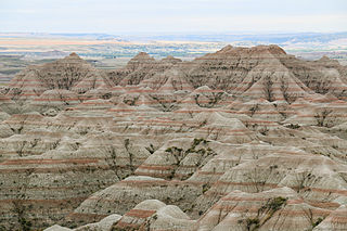
Badlands National Park is an American national park located in southwestern South Dakota. The park protects 242,756 acres of sharply eroded buttes and pinnacles, along with the largest undisturbed mixed grass prairie in the United States. The National Park Service manages the park, with the South Unit being co-managed with the Oglala Lakota tribe.

National Grassland is a classification of protected and managed federal lands in the United States authorized by Title III of the Bankhead–Jones Farm Tenant Act of 1937. For administrative purposes, they are essentially identical to United States National Forests, except that grasslands are areas primarily consisting of prairie. Like National Forests, National Grasslands may be open for hunting, grazing, mineral extraction, recreation and other uses. Various National Grasslands are typically administered in conjunction with nearby National Forests.

The Malheur National Forest is a National Forest in the U.S. state of Oregon. It contains more than 1.4 million acres (5,700 km2) in the Blue Mountains of eastern Oregon. The forest consists of high desert grasslands, sage, juniper, pine, fir, and other tree species. Elevations vary from about 4,000 feet (1,200 m) to the 9,038-foot (2,755 m) peak of Strawberry Mountain. The Strawberry Mountains extend east to west through the center of the forest. U.S. Route 395 runs south to north through the forest, while U.S. Route 26 runs east to west.

The Oglala National Grassland is a United States National Grassland in the northwest corner of Nebraska. It is in northern Sioux and northwestern Dawes counties, on the borders with South Dakota and Wyoming. It is 94,520 acres (38,250 ha) in size and is one of the small handful of National Grasslands administered by the US Department of Agriculture's Forest Service. It is managed by the U.S. Forest Service together with the Nebraska and Samuel R. McKelvie National Forests and the Buffalo Gap and Fort Pierre National Grasslands from common offices in Chadron, Nebraska.

Butte Valley National Grassland is a 18,425-acre (7,456 ha) United States National Grassland located in northern California. Administered by the United States Forest Service, it is located in northern Siskiyou County, near the Oregon border, between the communities of Dorris and Macdoel along U.S. Highway 97. It was dedicated in July 1991 as the nation's 20th National Grassland. It is administered as part of the Klamath National Forest, and is the sole National Grassland in California and in Region 5 of the Forest Service. Administrative offices are located in Macdoel, California.

The Midewin National Tallgrass Prairie (MNTP) is a tallgrass prairie reserve and United States National Grassland operated by the United States Forest Service. The first national tallgrass prairie ever designated in the U.S. and the largest conservation site in the Chicago Wilderness region, it is located on the site of the former Joliet Army Ammunition Plant between the towns of Elwood, Manhattan and Wilmington in northeastern Illinois. Since 2015, it has hosted a conservation herd of American bison to study their interaction with prairie restoration and conservation.

Custer National Forest is located primarily in the south central part of the U.S. state of Montana but also has separate sections in northwestern South Dakota. With a total area of 1,188,130 acres (4,808 km2), the forest comprises over 10 separate sections. While in the westernmost sections, Custer National Forest is a part of the Greater Yellowstone Ecosystem, the easternmost sections are a combination of forest "islands" and grasslands. A portion of the forest is also part of the Absaroka-Beartooth Wilderness and constitutes over a third of the wilderness land. South of Red Lodge, Montana, the Beartooth Highway passes through the forest en route to Yellowstone National Park.

Medicine Bow – Routt National Forest is the official title to a U.S. Forest Service managed area extending over 2,222,313 acres (8,993.38 km2) in the states of Wyoming and Colorado, United States. What were once three separate areas, Medicine Bow National Forest, Routt National Forest and Thunder Basin National Grassland were administratively combined in 1995 due to similarity of the resources, proximity to each other and for administrative purposes.

The Nebraska National Forest is a United States National Forest located within the U.S. state of Nebraska. The total area of the national forest is 141,864 acres, or 222 sq miles. The forest is managed by the U.S. Forest Service's Nebraska Forests and Grasslands Supervisor's Office in Chadron, Nebraska. The national forest includes two ranger districts, the Bessey Ranger District and the Pine Ridge Ranger District. In descending order of land, the forest lies in parts of Thomas, Dawes, Blaine, and Sioux counties.

Black Hills National Forest is located in southwestern South Dakota and northeastern Wyoming, United States. The forest has an area of over 1.25 million acres (5,066 km²) and is managed by the Forest Service. Forest headquarters are located in Custer, South Dakota. There are local ranger district offices in Custer, Rapid City, and Spearfish in South Dakota, and in Sundance, Wyoming.
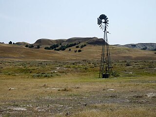
Buffalo Gap National Grassland is a National Grassland located primarily in southwestern South Dakota, United States. It is also the second largest National Grassland, after Little Missouri National Grassland in North Dakota. Characteristics of the grasslands include mixed prairie and chalky badlands. The grassland is managed by the U.S. Forest Service and is a division of Nebraska National Forest. In descending order of land area it is located in parts of Fall River, Pennington, Jackson, and Custer counties.

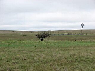
Fort Pierre National Grassland is a United States National Grassland in central South Dakota, south of the capital city Pierre and its neighbor Fort Pierre. The national grassland is primarily a short grass prairie and has a land area of 115,890 acres (46,900 ha). In descending order of area it lies in parts of Lyman, Stanley, and Jones counties. Part of the movie Dances with Wolves was filmed there. It is managed by the U.S. Forest Service together with the Nebraska and Samuel R. McKelvie National Forests and the Buffalo Gap and Oglala National Grasslands from common offices in Chadron, Nebraska. There is a local ranger district office located in Pierre.
Kiowa National Grassland is a National Grassland, located in northeastern New Mexico. The southwestern Great Plains grassland includes prairie and part of the Canadian River Canyon.

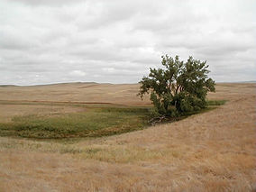
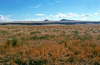
Little Missouri National Grassland is a National Grassland located in western North Dakota, USA. At 1,028,051 acres (416,037 ha), it is the largest grassland in the country. Enclaved within its borders is Theodore Roosevelt National Park, which is managed by the National Park Service. The Little Missouri National Grassland was once a part of the Custer National Forest, but is now a part of the Dakota Prairie Grasslands, a National Forest unit consisting entirely of National Grasslands. A predominant feature of the grassland is colorful and beautiful badlands, a rugged terrain extensively eroded by wind and water. It is a mixed grass prairie, meaning it has both long and short grass.
Rita Blanca National Grassland is a National Grassland on the Great Plains near the community of Texline in northwest Dallam County, Texas, in the Texas Panhandle, and in southern Cimarron County, Oklahoma, in the western Oklahoma Panhandle. The principal city in the area is Dalhart, Texas, which houses the XIT Museum.

Sheyenne National Grassland is a National Grassland located in southeastern North Dakota in the United States, comprising 70,446 acres (28,508 ha) of public land amid 64,769 acres (26,211 ha) of privately owned land in a region of sandy soils in the vicinity of the Sheyenne River in Ransom and Richland Counties. It is the only National Grassland in the tallgrass prairie region of the U.S. The grassland provides habitat for the largest population of greater prairie chickens in North Dakota, as well as the Dakota skipper butterfly, the western prairie fringed orchid, and numerous ferns, as well as grazing land for approximately 83 cattle ranchers.

The Long Prairie River is a tributary of the Crow Wing River, 96 miles (154 km) long, in central Minnesota in the United States. Via the Crow Wing River, it is part of the watershed of the Mississippi River, draining an area of 892 square miles (2,310 km2) in a generally rural region.

South Dakota is a state located in the north-central United States. It is usually considered to be in the Midwestern region of the country. The state can generally be divided into three geographic regions: eastern South Dakota, western South Dakota, and the Black Hills. Eastern South Dakota is lower in elevation and higher in precipitation than the western part of the state, and the Black Hills are a low, isolated mountain group in the southwestern corner of the state. Smaller sub-regions in the state include the Coteau des Prairies, Coteau du Missouri, James River Valley, the Dissected Till Plains, and the Badlands. Geologic formations in South Dakota range in age from two billion-year-old Precambrian granite in the Black Hills to glacial till deposited over the last few million years. South Dakota is the 17th-largest state in the country.