
The Bald Knob National Wildlife Refuge is a 15,022 acres (60.79 km2) (2014) wildlife refuge located in White County, Arkansas about two miles south of the town of Bald Knob. The refuge is managed by the United States Fish and Wildlife Service. The refuge features large numbers of migratory waterfowl and bald eagles during the winter months.

The Innoko National Wildlife Refuge is a national wildlife refuge of the United States located in western Alaska. It consists of 3,850,481 acres (15,582 km2), of which 1,240,000 acres (5,018 km2) is designated a wilderness area. It is the fifth-largest national wildlife refuge in the United States. The refuge is administered from offices in Galena.

Missisquoi National Wildlife Refuge is a National Wildlife Refuge in the U.S. state of Vermont located on the eastern shore of Lake Champlain and the southern side of Missisquoi Bay. The refuge is in Franklin County in the northwest corner of the state near the International Boundary with Canada.

Browns Park National Wildlife Refuge is a 13,450-acre (5,440 ha) U.S. National Wildlife Refuge located in northwestern Colorado. It is located in Moffat County in the extreme northwestern corner of the state, in an isolated mountain valley of Browns Park on both sides of the Green River, approximately 25 miles (40 km) below Flaming Gorge Dam. Established in 1965, the refuge is managed by the United States Fish and Wildlife Service office in Maybell, Colorado. The refuge is approximately 53 miles (85 km) northwest of Maybell on State Highway 318. The refuge consists of bottomland and adjacent benchland. The western border of the refuge is the Colorado-Utah state line. The refuge is surrounded by adjacent lines of the Bureau of Land Management. The refuge contains the site of the former Fort Davy Crockett that was constructed in 1837 to protect trappers against attacks by Blackfoot Native Americans.

Ridgefield National Wildlife Refuge is a National Wildlife Refuge and is overseen by the United States Fish and Wildlife Service. The refuge borders the Columbia River and is located west of the city of Ridgefield, Washington. The wildlife haven is split by Lake River. The refuge, which provides a year-round habitat and a migration stop for a variety of bird species, protects more than 5,200 acres (2,100 ha) of marshes, grasslands, and woodlands

Don Edwards San Francisco Bay National Wildlife Refuge (DESFBNWR) is a United States National Wildlife Refuge located in the southern part of San Francisco Bay, California. Its headquarters and visitor center are in the Baylands district of Fremont, next to Coyote Hills Regional Park, in Alameda County. The visitor center is on Marshlands Rd, off Thornton Ave.
Sand Lake National Wildlife Refuge is located in the northeastern part of the U.S. state of South Dakota and is administered by the U.S. Fish and Wildlife Service. Created in 1935, it is a wetland of international importance and a Globally Important Bird Area. Over 260 bird species are found in the refuge, including many migratory bird species and the world's largest breeding colony of Franklin's gulls.

Baskett Slough National Wildlife Refuge is in northwestern Oregon, 10 miles (16 km) west of Salem in Polk County. The Refuge consists of 1,173 acres (4.75 km2) of cropland, which provide forage for wintering geese, 300 acres (1.2 km2) of forests, 550 acres (2.2 km2) of grasslands, and 500 acres (2.0 km2) of shallow water seasonal wetlands and 35 acres (0.14 km2) of permanent open water. In 1965, Baskett Slough National Wildlife Refuge was created to help ensure some of the original habitat remained for species preservation. The refuge is managed by the U.S. Fish and Wildlife Service, an agency of the U.S. Department of the Interior.
The Occoquan Bay National Wildlife Refuge is a National Wildlife Refuge located where the Occoquan River meets the Potomac River in Woodbridge, Virginia, United States between Belmont Bay and Occoquan Bay. The 644-acre (2.61 km2) site, about half of which is wetlands, was a popular tourist spot known as Dawson Beach until the 1940s, after which it was used for military research by the U.S. Army's Harry Diamond Laboratories from the 1960s to the 1990s. When the land was purchased from the military, it was temporarily called the Marumsco National Wildlife Refuge. The refuge was formally established and renamed in 1998, and is now managed by the United States Fish and Wildlife Service as part of the Potomac River National Wildlife Refuge Complex.

D'Arbonne National Wildlife Refuge is a National Wildlife Refuge of the United States located north of West Monroe, Louisiana. It is in Ouachita and Union Parishes on either side of Bayou D'Arbonne near its confluence with the Ouachita River. It lies on the western edge of the Mississippi River alluvial valley. It was established in 1975 to protect bottomland hardwoods and provide wintering habitat for migratory waterfowl. D'Arbonne is one of four refuges managed in the North Louisiana Refuges Complex.
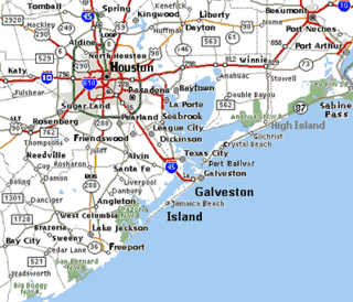
The Brazoria National Wildlife Refuge is a 44,414-acre (179.74 km2) wildlife conservation area along the coast of Texas (USA), east of the towns of Angleton and Lake Jackson, Texas. It borders Christmas Bay and the Intracoastal Waterway, separated from the Gulf of Mexico by Follet's Island.

The San Bernardino National Wildlife Refuge is located on the U.S.-Mexico border in Cochise County, Arizona. Situated at 3,720 to 3,920 feet (1,130–1,190 m) elevation in the bottom of a wide valley, the refuge encompasses a portion of the headwaters of the Yaqui River, which drains primarily western Chihuahua and eastern Sonora, Mexico. The 2,309-acre (9.34 km2) ranch was acquired by the U.S. Fish and Wildlife Service in 1982 to protect the water resources and provide habitat for endangered native fishes.

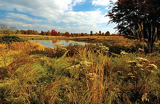
Straddling the headwaters of the Minnesota River in west-central Minnesota, Big Stone National Wildlife Refuge is within the heart of the tallgrass prairie's historic range. Today, less than one-percent of tallgrass prairie remains.

Roanoke River National Wildlife Refuge was established in 1989 to protect and enhance wooded wetlands consisting of bottomland hardwoods and swamps with high waterfowl value along the Roanoke River. The extensive bottomland hardwood habitat of the Roanoke River National Wildlife Refuge is part of what the Nature Conservancy calls "one of the last great places."

Conboy Lake National Wildlife Refuge is located on the east slope of the Cascade Mountains at the base of 12,281-foot (3,743 m) Mount Adams in southern Washington state.
McNary National Wildlife Refuge is a wildlife preserve, one of the national wildlife refuges operated by the United States Fish and Wildlife Service. Extending along the east bank of the Columbia River in southeastern Washington, from the confluence of the Snake River to the mouth of the Walla Walla River, and downstream into Oregon, McNary NWR is located in rural Burbank, but very close to the rapid development of the Tri-Cities. In fact, the refuge meets the definition of an "urban refuge." Few areas in North America support waterfowl populations in the extraordinary numbers found here. There are spectacular concentrations of Canada geese, mallards, and other waterfowl. More than half the mallards in the Pacific Flyway overwinter at some time in this portion of the Columbia River Basin.

The Umatilla National Wildlife Refuge is located on and around the Columbia River about 15 miles (24 km) northwest of Hermiston, Oregon and includes 8,907 acres (3,605 ha) in Oregon, and 14,876 acres (6,020 ha) in Washington. It was established in 1969 to help mitigate habitat lose due to the flooding that occurred following the construction of the John Day Dam. The refuge is popular with birdwatchers and wildlife enthusiasts.

The San Luis National Wildlife Refuge in the San Joaquin Valley of Central California is one of the great remnants of a historically bountiful wintering grounds for migratory waterfowl on the Pacific Flyway. Located in the Bear Creek, Salt Slough, and San Joaquin River floodplain, it hosts a myriad of tree-lined channels and oxbows, wetlands and native grasslands.
The Ellicott Slough National Wildlife Refuge is a United States National Wildlife Refuge located in the northern part of the Monterey Bay area of California.
The Grassland Ecological Area, also known as the Grasslands Ecological Area is a designated Ramsar Site in Central California. It covers an area of 250 square miles (650 km2) along the San Joaquin River in California's Central Valley. The wetlands are on the Pacific Flyway, and are an important habitat for resident and migratory waterbirds.
