
Beaver Lake State Park is a public recreation area located in Logan County, North Dakota, about equidistant from Napoleon and Wishek. The state park occupies 283 acres (115 ha) of land on the western shore of 968-acre (392 ha) Beaver Lake and offers hiking, boating, swimming, fishing, cabins, and campground.

Cross Ranch State Park is a public recreation area covering 589 acres (238 ha) on the west bank of the Missouri River in Oliver County, North Dakota. The state park is located 9 miles (14 km) south of Washburn and 22 miles (35 km) east of Center. It lies adjacent to the 6,000-acre (2,400 ha) Cross Ranch Nature Preserve, which features a roaming herd of more than 200 adult bison.

Devils Lake State Parks is the name sometimes applied to the units of the North Dakota state parks system located on Devils Lake, south of the city of Devils Lake in Ramsey County. As of 2017, only the larger remaining unit, 1,122-acre (454 ha) Grahams Island State Park, was in operation. The smaller Black Tiger Bay Recreation Area was closed due to inaccessibility. At one time there were four units on Devils Lake but rising water caused Narrows State Recreation Area to be closed in 1995 and Shelvers Grove's closure in 2004.

Fort Ransom State Park is a public recreation area located in the Sheyenne River valley two miles north of the town of Fort Ransom in Ransom County, North Dakota. The state park preserves two homesteader farms: the Bjone House and the Andrew Sunne farm. The park sits along the Sheyenne Valley National Scenic Byway, the first route in North Dakota to be given this designation.
Lake Metigoshe State Park is a public recreation area occupying 1,551 acres (628 ha) on the shores of Lake Metigoshe in the Turtle Mountains, 14 miles northeast of Bottineau, North Dakota, on the Canada–US border. The state park lies adjacent to the southwest corner of the much larger Turtle Mountain Provincial Park in Manitoba. A small portion of the lake extends northward into the Rural Municipality of Winchester but is not part of either park.
Little Missouri State Park is a public recreation area covering nearly 4,600 acres (1,900 ha) along the Little Missouri River, near the river's confluence with Lake Sakakawea, located approximately 12 miles (19 km) due north of Killdeer, North Dakota. Much of the state park consists of badlands terrain that is only accessible by trail. The park has about 47 miles (76 km) of trails as well as campgrounds for hiking and equestrian use. The majority of the park's area is managed under lease from federal and private owners.

Icelandic State Park is a public recreation area located on Lake Renwick five miles (8.0 km) west of Cavalier in Akra Township, Pembina County, North Dakota. The state park's 912 acres (369 ha) include the Pioneer Heritage Center and the Gunlogson Homestead and Nature Preserve.

Turtle River State Park is a public recreation area occupying 784 acres (317 ha) along the Turtle River north of the community of Arvilla in Grand Forks County, North Dakota. Park activities include camping, cross-country skiing, fishing, hiking, and mountain biking. The park also features an outdoor learning center.
Butte Saint Paul State Recreation Area is a 10-acre (4.0 ha) North Dakota state park unit located northwest of Dunseith in Bottineau County. The park encompasses 580-foot (180 m) Butte Saint Paul. A 12-foot (3.7 m) stone cairn and commemorative plaque sit atop the peak. Visitors can take in expansive views of the surrounding Turtle Mountain region.
Crow Flies High State Recreation Area is a day-use state park in Mountrail County, North Dakota, west of the community of New Town. The site provides scenic views of Lake Sakakawea. Signs describe the location's role in local history, including its significance in the explorations of Lewis and Clark. The footprint of the drowned town of Sanish, now lost below the reservoir's waves, can be seen at times of low water.

Fort Stevenson State Park is a public recreation area located on a peninsula on Lake Sakakawea four miles (6.4 km) south of the community of Garrison in McLean County, North Dakota. The state park's 549 acres (222 ha) include a partial reconstruction of Fort Stevenson, the 19th-century Missouri River fort from which the park takes its name. The site of the original fort lies about two miles southwest, below the waters of Lake Sakakawea.
Pelican Point State Recreation Area is an undeveloped, day-use unit of the North Dakota state park system located on Lake Metigoshe, northeast of the community of Bottineau. The area is only accessible on foot; there are no developed trails.

Lake Sakakawea State Park is a public recreation area occupying 1,293 acres (523 ha) on the southern shore of Lake Sakakawea in Mercer County, North Dakota. The state park is located adjacent to the Garrison Dam, one mile (1.6 km) north of the community of Pick City.
Lewis and Clark State Park is a public recreation area occupying 490 acres (200 ha) on the north shore of the far western, upper reaches of Lake Sakakawea in Williams County, North Dakota. The state park, which is 19 miles east of Williston, is used for fishing, boating, camping, and picnicking.
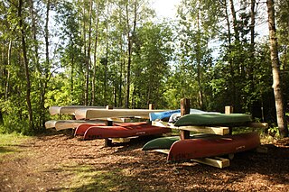
Sully Creek State Park is a public recreation area located along the eastern banks of the Little Missouri River about 2 miles (3.2 km) south of Medora in Billings County, North Dakota. The state park is used for camping, horse camping, and canoeing. It was created in 1970.
Indian Hills State Recreation Area and Resort is a unit of the North Dakota state park system located on the north shore of Lake Sakakawea 31 miles (50 km) west of Garrison and operated as a commercial venture by a private leasee. The resort offers camping, lodging, boating, fishing, and trails for hiking and biking.
Little Metigoshe State Recreation Area is a smaller unit of the North Dakota state park system located on the east shore of Lake Metigoshe near Lake Metigoshe State Park. It is situated in the Turtle Mountains adjacent to the international border between Canada and the United States. The area offers picnicking, a fishing dock, and wintertime access to ice fishing. The 1,500-acres park offers boating as well as cross-country skiing and hiking trails.
Pembina Gorge State Recreation Area is a unit of the North Dakota state park system located along the Pembina River that provides a 12-mile (19 km) looped trail for riding ATVs, dirt bikes, and other forms of off-road vehicles. Non-motorized use by equestrians, mountain bikers, and hikers is also allowed. In 2014 plants were collected in the Pembina Gorge. The final count was 209 species, which includes prior collections.
The North Dakota Parks and Recreation Department is the state agency that administers selected state parks and recreation areas for the state of North Dakota.
