
Uncompahgre Peak is the sixth highest summit of the Rocky Mountains of North America and the U.S. state of Colorado. The prominent 14,316-foot (4363.46 m) fourteener is the highest summit of the San Juan Mountains and the highest point in the drainage basin of the Colorado River and the Gulf of California. It is located in the Uncompahgre Wilderness in the northern San Juans, in northern Hinsdale County approximately 7 miles (11 km) west of the town of Lake City.

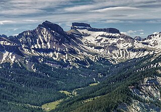
Wetterhorn Peak is a fourteen thousand-foot mountain peak in the U.S. state of Colorado. It is located in the Uncompahgre Wilderness of the northern San Juan Mountains, in northwestern Hinsdale County and southeastern Ouray County, approximately 9 miles (14 km) east of the town of Ouray and 2.75 mi (4.4 km) west of Uncompahgre Peak.
Ouray Peak, elevation 12,963 ft (3,951 m), is a summit in the Sawatch Mountains of Colorado. The peak is 6 mi (9.7 km) south of Independence Pass in the Collegiate Peaks Wilderness of San Isabel National Forest.

Winfield Peak is a mountain summit of the Collegiate Peaks in the Sawatch Range of the Rocky Mountains of North America. The 13,084-foot (3,988 m) summit is located in Chaffee County, Colorado, U.S., two miles north of the ghost town of Winfield.

Mount Blaurock is a high mountain summit of the Collegiate Peaks in the Sawatch Range of the Rocky Mountains of North America. The 13,623-foot (4,152 m) thirteener is located in San Isabel National Forest, 21.1 miles (33.9 km) northwest by west of the Town of Buena Vista in Chaffee County, Colorado, United States. Mount Blaurock was named in honor of Carl Blaurock, a co-founder of the Colorado Mountain Club and one of the first two persons to climb all of Colorado's fourteeners.
Middle Peak is a high and prominent mountain summit in the San Miguel Mountains range of the Rocky Mountains of North America. The 13,306-foot (4,056 m) peak is located in the Lizard Head Wilderness, 17.1 miles (27.6 km) west-southwest of the Town of Telluride, Colorado, United States, on the drainage divide separating San Juan National Forest and Dolores County from Uncompahgre National Forest and San Miguel County.
Castle Peak is a prominent mountain summit in the northern Sawatch Range of the Rocky Mountains of North America. The 11,305-foot (3,446 m) peak is located 9.6 miles (15.5 km) north of the Town of Eagle in Eagle County, Colorado, United States.

West Elk Peak, elevation 13,042 ft (3,975 m), is the highest summit in the West Elk Mountains of Gunnison County, Colorado. The mountain is in the West Elk Wilderness, northwest of Gunnison. The terrain consists mostly of volcanic breccia, known in this area as West Elk Breccia, dated at 35 to 30 million years old.

Lone Cone is a prominent mountain summit at the western end of the San Miguel Mountains range of the Rocky Mountains of North America. The 12,618-foot (3,846 m) peak is located 24.2 miles (38.9 km) west by south of the Town of Telluride, Colorado, United States, on the drainage divide separating San Juan National Forest and Dolores County from Uncompahgre National Forest and San Miguel County.

Little Cone is a prominent mountain summit in the San Miguel Mountains range of the Rocky Mountains of North America. The 11,988-foot (3,654 m) peak is located in Uncompahgre National Forest, 15.0 miles (24.1 km) west of the Town of Telluride in San Miguel County, Colorado, United States.
Casco Peak is a high mountain summit in the Sawatch Range of the Rocky Mountains of North America. The 13,915-foot (4,241 m) thirteener is located on the Elbert Massif in San Isabel National Forest, 3.8 miles (6.1 km) east of Independence Pass in Lake County, Colorado, United States.

Dallas Peak is a high mountain summit in the Sneffels Range of the Rocky Mountains of North America. The 13,815-foot (4,211 m) thirteener is located in the Mount Sneffels Wilderness of Uncompahgre National Forest, 3.3 miles (5.3 km) north by west of the Town of Telluride, Colorado, United States, on the drainage divide between Ouray and San Miguel counties.

Emerald Peak is a high mountain summit of the Collegiate Peaks in the Sawatch Range of the Rocky Mountains of North America. The 13,911-foot (4,240 m) thirteener is located in the Collegiate Peaks Wilderness of San Isabel National Forest, 14.7 miles (23.7 km) west-northwest of the Town of Buena Vista in Chaffee County, Colorado, United States.

Gladstone Peak is a high mountain summit in the San Miguel Mountains range of the Rocky Mountains of North America. The 13,919-foot (4,243 m) thirteener is located in the Lizard Head Wilderness, 11.2 miles (18.0 km) southwest by west of the Town of Telluride, Colorado, United States, on the drainage divide separating San Juan National Forest and Dolores County from Uncompahgre National Forest and San Miguel County. The mountain was named in honor of British Prime Minister William Gladstone.

Green Mountain is a mountain summit on the eastern flank of the Front Range of the Rocky Mountains of North America. The 8,148-foot (2,484 m) peak is located in Boulder Mountain Park, 4.2 miles (6.8 km) southwest by south of downtown Boulder in Boulder County, Colorado, United States. The mountain is renowned for the Flatirons rock formations on its eastern flank.
Horsefly Peak is the highest summit of the Uncompahgre Plateau in the Rocky Mountains of North America. The 10,353-foot (3,156 m) peak is located 10.0 miles (16.1 km) west by north of the Town of Ridgway in Ouray County, Colorado, United States.

Pacific Peak, elevation 13,957 ft (4,254 m), is a summit in the Mosquito Range of central Colorado. The peak is southwest of Breckenridge in the Arapaho National Forest. Its long east ridge is prominently visible across the valley to the north when hiking Quandary Peak, a popular 14er in Colorado. It is often hiked together with nearby Atlantic Peak. Pacific Tarn, the highest officially named lake in the United States, lies high on the eastern flank of the peak.

Teakettle Mountain, elevation 13,825 ft (4,214 m), is a summit in the Sneffels Range of southwest Colorado. The peak is west of Ouray in the Uncompahgre National Forest.

Gilpin Peak is a high mountain summit in the Sneffels Range of the Rocky Mountains of North America. The 13,700-foot (4,176 m) thirteener is located in the Mount Sneffels Wilderness of Uncompahgre National Forest, 3.5 miles (5.6 km) north-northeast of the Town of Telluride, Colorado, United States, on the drainage divide between Ouray County and San Miguel County. Gilpin Peak was named in honor of William Gilpin, the first Governor of the Territory of Colorado.
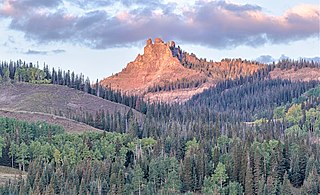
Coxcomb Peak is a 13,656-foot-elevation (4,162-meter) mountain summit located on the common boundary of Hinsdale County and Ouray County, in Colorado, United States. It is situated nine miles northeast of the community of Ouray, in the Uncompahgre Wilderness, on land managed by Uncompahgre National Forest. It is part of the San Juan Mountains which are a subset of the Rocky Mountains, and is situated west of the Continental Divide. Coxcomb ranks as the 171st-highest peak in Colorado, and topographic relief is significant as the south aspect rises 2,000 feet above Wetterhorn Basin in approximately one mile, and 4,400 feet above Cow Creek in three miles. Neighbors include Precipice Peak 2.7 miles to the north, Redcliff one-half mile north, Matterhorn Peak 2.3 miles to the east-southeast, and nearest higher neighbor Wetterhorn Peak 1.8 mile to the southeast. The mountain's descriptive name, which has been officially adopted by the United States Board on Geographic Names, was in use since at least 1906 when Henry Gannett published it in the Gazetteer of Colorado.

