
Mount Bailey is a mountain summit in the Front Range of the Rocky Mountains of North America. The 9,089-foot (2,770 m) peak is located 1.0 mile (1.6 km) northeast of the community of Bailey in Park County, Colorado, United States.

The Twin Sisters Peaks are mountains in Colorado, located in the Front Range in Larimer County, Colorado, straddling Rocky Mountain National Park and Roosevelt National Forest.

Mount Julian is a mountain summit in the northern Front Range of the Rocky Mountains of North America. The 12,933-foot (3,942 m) peak is located in the Rocky Mountain National Park Wilderness, 12.2 miles (19.7 km) west of the Town of Estes Park in Larimer County, Colorado, United States. The mountain was named in honor of Julian Hayden, a civil engineer who lived in Estes Park.
Matterhorn Peak is a high mountain summit in the San Juan Mountains range of the Rocky Mountains of North America. The 13,596-foot (4,144 m) thirteener is located in the Uncompahgre Wilderness of Uncompahgre National Forest, 10.3 miles (16.6 km) west by north of the Town of Lake City in Hinsdale County, Colorado, United States.
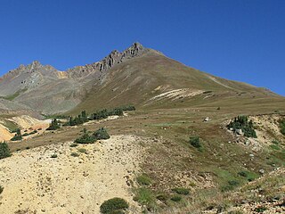
Shawnee Peak, elevation 11,932 ft (3,637 m), is a summit in the Kenosha Mountains of central Colorado. The peak is in the Lost Creek Wilderness of Pike National Forest west of Bailey.
Meridian Peak is a mountain summit in the Gore Range of the Rocky Mountains of North America. The 12,432-foot (3,789 m) peak is located in the Eagles Nest Wilderness, 9.0 miles (14.5 km) north by west of the Town of Vail, Colorado, United States, on the drainage divide separating White River National Forest and Eagle County from Arapaho National Forest and Summit County.

Mount Blaurock is a high mountain summit of the Collegiate Peaks in the Sawatch Range of the Rocky Mountains of North America. The 13,623-foot (4,152 m) thirteener is located in San Isabel National Forest, 21.1 miles (33.9 km) northwest by west of the Town of Buena Vista in Chaffee County, Colorado, United States. Mount Blaurock was named in honor of Carl Blaurock, a co-founder of the Colorado Mountain Club and one of the first two persons to climb all of Colorado's fourteeners.
North Mamm Peak is a prominent mountain summit on Grand Mesa in the Rocky Mountains of North America. The 11,129-foot (3,392 m) peak is located in White River National Forest, 11.6 miles (18.6 km) south-southwest of the Town of Rifle in Garfield County, Colorado, United States.
Castle Peak is a prominent mountain summit in the northern Sawatch Range of the Rocky Mountains of North America. The 11,305-foot (3,446 m) peak is located 9.6 miles (15.5 km) north of the Town of Eagle in Eagle County, Colorado, United States.

Mount Audubon is a high mountain summit of the Indian Peaks in the northern Front Range of the Rocky Mountains of North America. The 13,229-foot (4,032 m) thirteener is located in the Indian Peaks Wilderness of Roosevelt National Forest, 5.6 miles (9.0 km) west-northwest of the Town of Ward in Boulder County, Colorado, United States. The mountain was named in honor of John James Audubon.
Casco Peak is a high mountain summit in the Sawatch Range of the Rocky Mountains of North America. The 13,915-foot (4,241 m) thirteener is located on the Elbert Massif in San Isabel National Forest, 3.8 miles (6.1 km) east of Independence Pass in Lake County, Colorado, United States.

Cathedral Peak is a high mountain summit in the Elk Mountains range of the Rocky Mountains of North America. The 13,950-foot (4,252 m) thirteener is located in the Maroon Bells-Snowmass Wilderness of White River National Forest, 11.1 miles (17.9 km) south by west of the City of Aspen in Piktin County, Colorado, United States.

Emerald Peak is a high mountain summit of the Collegiate Peaks in the Sawatch Range of the Rocky Mountains of North America. The 13,911-foot (4,240 m) thirteener is located in the Collegiate Peaks Wilderness of San Isabel National Forest, 14.7 miles (23.7 km) west-northwest of the Town of Buena Vista in Chaffee County, Colorado, United States.
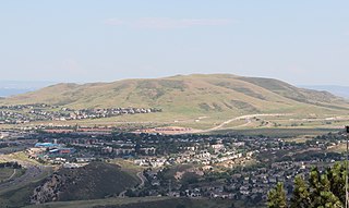
Green Mountain is a mesa on the eastern flank of the Front Range of the Rocky Mountains of North America. The 6,854-foot (2,089 m) mesa summit is located in William Frederick Hayden Park in the City of Lakewood, Colorado, United States, 4.0 miles (6.5 km) west of the municipal center of Lakewood in Jefferson County.

Green Mountain is a mountain summit on the eastern flank of the Front Range of the Rocky Mountains of North America. The 8,148-foot (2,484 m) peak is located in Boulder Mountain Park, 4.2 miles (6.8 km) southwest by south of downtown Boulder in Boulder County, Colorado, United States. The mountain is renowned for the Flatirons rock formations on its eastern flank.

Mount Hope is a high mountain summit of the Collegiate Peaks in the Sawatch Range of the Rocky Mountains of North America. The 13,939-foot (4,249 m) thirteener is located in San Isabel National Forest, 20.1 miles (32.3 km) northwest of the Town of Buena Vista in Chaffee County, Colorado, United States.

Pacific Peak, elevation 13,957 ft (4,254 m), is a summit in the Mosquito Range of central Colorado. The peak is southwest of Breckenridge in the Arapaho National Forest. Its long east ridge is prominently visible across the valley to the north when hiking Quandary Peak, a popular 14er in Colorado. It is often hiked together with nearby Atlantic Peak. Pacific Tarn, the highest officially named lake in the United States, lies high on the eastern flank of the peak.

Peak 10, elevation 13,640 ft (4,157 m), is a summit in the Tenmile Range of central Colorado. The peak is southwest of Breckenridge in the Arapaho National Forest.
Garfield Peak is a high mountain summit of the Collegiate Peaks in the Sawatch Range of the Rocky Mountains of North America. The 13,787-foot (4,202 m) thirteener is located 5.6 miles (9.0 km) south-southwest of Independence Pass, Colorado, United States, on the Continental Divide separating San Isabel National Forest and Chaffee County from White River National Forest and Pitkin County. Garfield Peak was named in honor of James A. Garfield, 20th President of the United States.

Gilpin Peak is a high mountain summit in the Sneffels Range of the Rocky Mountains of North America. The 13,700-foot (4,176 m) thirteener is located in the Mount Sneffels Wilderness of Uncompahgre National Forest, 3.5 miles (5.6 km) north-northeast of the Town of Telluride, Colorado, United States, on the drainage divide between Ouray County and San Miguel County. Gilpin Peak was named in honor of William Gilpin, the first Governor of the Territory of Colorado.

