| Engineer Mountain | |
|---|---|
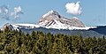
 Southeast aspect | |
| Highest point | |
| Elevation | 12,968 ft (3,953 m) [1] |
| Prominence | 1,408 ft (429 m) [1] |
| Parent peak | Rolling Mountain (13,693 ft) [2] |
| Isolation | 4.74 mi (7.63 km) [2] |
| Coordinates | 37°41′57″N107°48′24″W / 37.6992257°N 107.8067202°W [3] |
| Geography | |
 Engineer Mountain Location in Colorado  Engineer Mountain Engineer Mountain (the United States) | |
| Country | United States |
| State | Colorado |
| County | San Juan |
| Protected area | San Juan National Forest |
| Parent range | Rocky Mountains San Juan Mountains |
| Topo map | USGS Engineer Mountain |
| Geology | |
| Rock age | Tertiary [4] |
| Rock type(s) | Quartz trachyte, Cutler Formation [4] |
| Climbing | |
| Easiest route | class 3 scramble [2] Northeast Ridge |
Engineer Mountain is a 12,968-foot-elevation (3,953-meter) mountain summit located in San Juan County, Colorado, United States. [3] It is part of the San Juan Mountains range which is a subset of the Rocky Mountains, and is west of the Continental Divide. Engineer Mountain is a prominent landmark set 1.5 mile immediately west of Coal Bank Pass, and is visible from multiple viewpoints along Highway 550, making it one of the most photographed mountains in the San Juans. [5] It is situated 11 miles southwest of the community of Silverton, on land managed by San Juan National Forest. Topographic relief is significant as the southwest aspect rises 3,800 feet (1,200 meters) above Cascade Creek in approximately two miles. Neighbors include Snowdon Peak seven miles to the east, and Twilight Peak, five miles to the southeast.