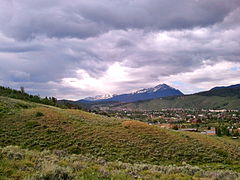
Breckenridge is the home rule municipality that is the county seat and the most populous municipality of Summit County, Colorado, United States. The town population was 5,078 at the 2020 United States Census. Breckenridge is the principal town of the Breckenridge, CO Micropolitan Statistical Area. The town also has many part-time residents, as many people have vacation homes in the area. The town is located at the base of the Tenmile Range.

Keystone is an unincorporated community and a census-designated place (CDP) located in and governed by Summit County, Colorado, United States. The CDP is a part of the Breckenridge, CO Micropolitan Statistical Area. The population of the Keystone CDP was 1,369 at the United States Census 2020. The Dillon post office (Zip Code 80435) serves Keystone postal addresses. The Keystone CDP includes the Keystone Resort and Keystone village.

A detachable chairlift or high-speed chairlift is a type of passenger aerial lift, which, like a fixed-grip chairlift, consists of numerous chairs attached to a constantly moving wire rope that is strung between two terminals over intermediate towers. They are now commonplace at all but the smallest of ski resorts. Some are installed at tourist attractions as well as for urban transportation.

The Blue River is a tributary of the Colorado River, approximately 65 miles (105 km) long, in the U.S. state of Colorado.

The Mosquito Range is a high mountain range in the Rocky Mountains of central Colorado in the United States. The peaks of the range form a ridge running north–south for roughly 40 mi (64 km) from southern Summit County on the north end, then along the boundary between Lake and Park Counties. The ranges forms a high barrier separating the headwaters of the Arkansas River near Leadville from South Park and the headwaters of the South Platte River near Fairplay. The highest peak in the range is Mount Lincoln at an elevation of 14,286 ft. Other fourteeners in the range are Quandary Peak (14,272 ft), Mount Bross (14,172 ft), Mount Democrat (14,148 ft), and Mount Sherman (14,036 ft).

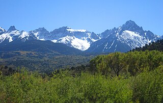
The Elk Mountains are a high, rugged mountain range in the Rocky Mountains of west-central Colorado in the United States. The mountains sit on the western side of the Continental Divide, largely in southern Pitkin and northern Gunnison counties, in the area southwest of Aspen, south of the Roaring Fork River valley, and east of the Crystal River. The range sits west of the Sawatch Range and northeast of the West Elk Mountains. Much of the range is located within the White River National Forest and the Gunnison National Forest, as well as the Maroon Bells-Snowmass Wilderness and Raggeds Wilderness. The Elk Mountains rise nearly 9,000 ft. above the Roaring Fork Valley to the north.

White River National Forest is a National Forest in northwest Colorado. It is named after the White River that passes through its northern section. It is the most visited National Forest in the United States, primarily from users of the twelve ski areas within its boundaries.

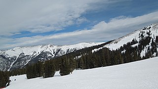
Copper Mountain is a mountain and ski resort located in Summit County, Colorado, about 75 miles (120 km) west of Denver on Interstate 70. The resort has 2,465 acres of in-bounds terrain under lease from the U.S. Forest Service, White River National Forest, Dillon Ranger District. It is operated by POWDR.

Quandary Peak is the highest summit of the Tenmile Range in the Rocky Mountains of North America and is the most commonly climbed fourteener in Colorado. It has nearly the same elevation as Castle Peak and Mount Evans. It lies in Summit County and within the White River National Forest about 6 miles (10 km) south-southwest of the town of Breckenridge.

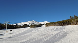
Breckenridge Ski Resort is an alpine ski resort in the western United States, in Breckenridge, Colorado. Recognized for acres of skiable terrain across five mountain peaks, it welcomes thousands of skiers and snowboarders each season. Just west of the Continental Divide in Summit County, it is perennially one of the most visited ski resorts in the western hemisphere. Breckenridge is owned and operated by Vail Resorts, Inc.
The Southern Rocky Mountains are a major subregion of the Rocky Mountains of North America located in the southeastern portion of the U.S. state of Wyoming, the central and western portions of Colorado, the northern portion of New Mexico, and extreme eastern portions of Utah. The Southern Rocky Mountains are also commonly known as the Southern Rockies, and since the highest peaks are located in the State of Colorado, they are sometimes known as the Colorado Rockies, although many important ranges and peaks rise in the other three states. The Southern Rockies include the highest mountain ranges of the Rocky Mountains and include all 30 of the highest major peaks of the Rockies.

Mount Sniktau is a high mountain summit in the Front Range of the Rocky Mountains of North America. The 13,240-foot (4,036 m) thirteener is located in Arapaho National Forest, 1.6 miles (2.5 km) northeast of Loveland Pass in Clear Creek County, Colorado, United States.

Grizzly Peak is a high mountain summit in the Front Range of the Rocky Mountains of North America. Also known as Grizzly Peak D, the 13,433-foot (4,094 m) thirteener is located in Arapaho National Forest, 2.1 miles (3.4 km) southeast by east of Loveland Pass, Colorado, United States, on the Continental Divide between Clear Creek and Summit counties. Its proximate parent peak is Torreys Peak.

Pacific Peak, elevation 13,957 ft (4,254 m), is a summit in the Mosquito Range of central Colorado. The peak is southwest of Breckenridge in the Arapaho National Forest. Its long east ridge is prominently visible across the valley to the north when hiking Quandary Peak, a popular 14er in Colorado. It is often hiked together with nearby Atlantic Peak. Pacific Tarn, the highest officially named lake in the United States, lies high on the eastern flank of the peak.

Peak 10, elevation 13,640 ft (4,157 m), is a summit in the Tenmile Range of central Colorado. The peak is southwest of Breckenridge in the Arapaho National Forest.

Atlantic Peak, elevation 13,835 ft (4,217 m), is a summit in the Tenmile Range of central Colorado. The peak is southwest of Breckenridge in the Arapaho National Forest. Its summit is visible close by to the northwest from the summit of Quandary Peak, a popular 14er in Colorado. It is often hiked together with nearby Pacific Peak.

John Lewis Dyer (1812-1901), "The Snowshoe Itinerant," was a circuit rider, that is, a preacher who rode from one church to the next. He was a Methodist.

Tenmile Peak is a 12,938-foot (3,944 m) mountain summit in Summit County, Colorado, United States.