Castle Peak is the ninth highest summit of the Rocky Mountains of North America and the U.S. state of Colorado. The prominent 14,272-foot (4350.20 m) fourteener is the highest summit of the Elk Mountains and the Maroon Bells-Snowmass Wilderness. The peak is located 11.6 miles (18.7 km) northeast by north of the Town of Crested Butte, Colorado, United States, on the drainage divide separating Gunnison National Forest and Gunnison County from White River National Forest and Pitkin County. The summit of Castle Peak is the highest point of both counties.

Aspen Mountain is a mountain summit in the Elk Mountains range of the Rocky Mountains of North America. The 11,212-foot (3,417 m) peak is located in White River National Forest, 1.4 miles (2.2 km) south-southeast of downtown Aspen in Pitkin County, Colorado, United States. The north face of the mountain is the location of the Aspen Mountain ski area, one of four adjacent ski areas operated collectively as Aspen/Snowmass.

North Arapaho Peak is the highest summit of the Indian Peaks in the northern Front Range of the Rocky Mountains of North America. The 13,508-foot (4,117 m) thirteener is located in the Indian Peaks Wilderness, 7.8 miles (12.6 km) west-southwest of the Town of Ward, Colorado, United States, on the Continental Divide separating Roosevelt National Forest and Boulder County from Arapaho National Forest and Grand County.

Braddock Peak is a mountain summit in the Never Summer Mountains range of the Rocky Mountains of North America. The 11,972-foot (3,649 m) peak is located in State Forest State Park, 3.0 miles (4.8 km) south-southwest of Cameron Pass in Jackson County, Colorado, United States.

Conejos Peak is a high and prominent mountain summit in the southern San Juan Mountains of the Rocky Mountains of North America. The 13,179-foot (4,017 m) thirteener is located in the South San Juan Wilderness of Rio Grande National Forest, 19.6 miles (31.6 km) north-northwest of Cumbres Pass in Conejos County, Colorado, United States. The summit of Conejos Peak is the highest point in Conejos County.

Badger Mountain is a mountain summit in the South Park Hills of the Rocky Mountains of North America. The 11,295-foot (3,443 m) peak is located in Pike National Forest, 9.6 miles (15.5 km) northwest by west of the community of Lake George in Park County, Colorado, United States.
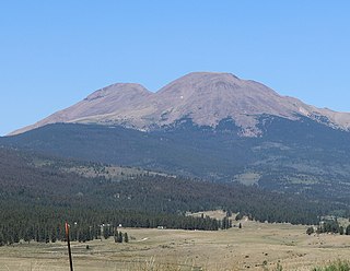
Mount Zirkel is the highest summit of the Park Range of the Rocky Mountains of North America. The prominent 12,185-foot (3,714 m) peak is located in the Mount Zirkel Wilderness of Routt National Forest, 25.9 miles (41.7 km) north-northeast of the City of Steamboat Springs, Colorado, United States, on the Continental Divide between Jackson and Routt counties. Mount Zirkel was named in honor of German geologist Ferdinand Zirkel.

Hagues Peak is the highest summit of the Mummy Range in the Rocky Mountains of North America. The 13,573-foot (4,137 m) thirteener is in the Rocky Mountain National Park Wilderness, 9.9 miles (15.9 km) northwest of the Town of Estes Park, Colorado, United States. Hagues Peak is the highest point in Larimer County, Colorado.
Crater Peak is the highest summit of Grand Mesa in the Rocky Mountains of North America. The prominent 11,333-foot (3,454 m) peak is located on the drainage divide separating Grand Mesa National Forest and Gunnison National Forest, 12.3 miles (19.8 km) north-northwest of the Town of Paonia in Delta County, Colorado, United States.

Bard Peak is a high and prominent mountain summit in the Front Range of the Rocky Mountains of North America. The 13,647-foot (4,160 m) thirteener is located in Arapaho National Forest, 4.5 miles (7.2 km) west-northwest of the Town of Silver Plume in Clear Creek County, Colorado, United States.

Bear Peak is a mountain summit in the Front Range of the Rocky Mountains of North America. The 8,459-foot (2,578 m) peak is located in Boulder Mountain Park, 5.2 miles (8.3 km) south-southwest of downtown Boulder in Boulder County, Colorado, United States.

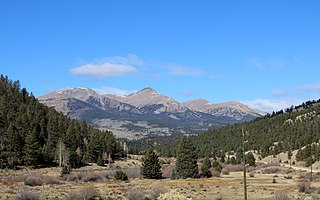
Mount Powell is the highest summit of the Gore Range in the Rocky Mountains of North America. The prominent 13,586-foot (4,141 m) thirteener is located in the Eagles Nest Wilderness, 8.5 miles (13.7 km) north by east of the Town of Vail, Colorado, United States, along the drainage divide separating White River National Forest and Eagle County from Arapaho National Forest and Summit County. Mount Powell was named in honor of John Wesley Powell who climbed to the summit in 1868.
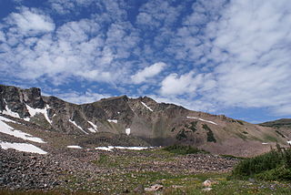
West Buffalo Peak, elevation 13,327 ft (4,062 m), is a summit in the Mosquito Range of central Colorado. The mountain is the highest peak of the Buffalo Peaks, slightly taller than East Buffalo Peak. It is located in the Buffalo Peaks Wilderness.
Antora Peak is a high and prominent mountain summit in the southern Sawatch Range of the Rocky Mountains of North America. The 13,275-foot (4,046 m) thirteener is located in Rio Grande National Forest, 4.6 miles (7.4 km) west-northwest of the Town of Bonanza in Saguache County, Colorado, United States.
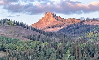
Castle Peak is a prominent mountain summit in the northern Sawatch Range of the Rocky Mountains of North America. The 11,305-foot (3,446 m) peak is located 9.6 miles (15.5 km) north of the Town of Eagle in Eagle County, Colorado, United States.
Bushnell Peak is a prominent mountain summit in the Sangre de Cristo Range of the Rocky Mountains of North America. The 13,110-foot (3,996 m) thirteener is located 7.2 miles (11.6 km) north-northeast of the community of Villa Grove, Colorado, United States, on the drainage divide separating Rio Grande National Forest and Saguache County from San Isabel National Forest and Fremont County. Bushnell Peak is the highest point in Fremont County.

Arrow Peak is a high mountain summit in the Grenadier Range of the Rocky Mountains of North America. The 13,809-foot (4,209 m) thirteener is located in the Weminuche Wilderness of San Juan National Forest, 8.7 miles (14.0 km) south-southeast of the Town of Silverton in San Juan County, Colorado, United States.
California Peak is a high mountain summit in the Sangre de Cristo Range of the Rocky Mountains of North America. The 13,855-foot (4,223 m) thirteener is located on the Sierra Blanca Massif, 12.1 miles (19.5 km) north of the Town of Blanca, Colorado, United States, on the drainage divide separating in Rio Grande National Forest and Alamosa County from San Isabel National Forest and Huerfano County.
Black Mountain is a prominent mountain summit in the South Park Hills of the Rocky Mountains of North America. The 11,649-foot (3,551 m) peak is located in Pike National Forest, 21.7 miles (34.9 km) south by east of the community of Hartsel in Park County, Colorado, United States.
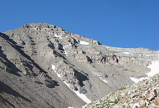
Horsefly Peak is the highest summit of the Uncompahgre Plateau in the Rocky Mountains of North America. The 10,353-foot (3,156 m) peak is located 10.0 miles (16.1 km) west by north of the Town of Ridgway in Ouray County, Colorado, United States.

