
In the mountaineering parlance of the Western United States, a fourteener is a mountain peak with an elevation of at least 14,000 ft (4267 m). The 96 fourteeners in the United States are all west of the Mississippi River. Colorado has the most (53) of any single state; Alaska is second with 29. Many peak baggers try to climb all fourteeners in the contiguous United States, one particular state, or another region.

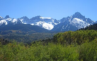
The Mount Sneffels Wilderness is a wilderness area in southwest Colorado managed by the Uncompahgre National Forest. It is about 5 miles (8.0 km) west of the town of Ouray. The area is named for Mt. Sneffels, which at 14,150 feet (4,310 m) is a prominent fourteener in the San Juan Mountains. The word "Sneffels" is likely an Americanization of the Old Norse word for Snæfell "snow mountain," which is also the namesake of the Snæfellsnes peninsula and Snæfellsjökull volcano in Iceland.
Mount Sneffels is the highest summit of the Sneffels Range in the Rocky Mountains of North America. The prominent 14,158-foot (4315.4 m) fourteener is located in the Mount Sneffels Wilderness of Uncompahgre National Forest, 6.7 miles (10.8 km) west by south of the City of Ouray in Ouray County, Colorado, United States. The summit of Mount Sneffels is the highest point in Ouray County.

Mount Wilson is the highest summit of the San Miguel Mountains range of the Rocky Mountains of North America. The prominent 14,252-foot (4,344 m) fourteener is located in the Lizard Head Wilderness of San Juan National Forest, 10.6 miles (17.1 km) north by east of the Town of Rico in Dolores County, Colorado, United States. Mount Wilson should not to be confused with the lower Wilson Peak nearby.

The Needle Mountains are a subrange of the San Juan Mountains of the Rocky Mountains located in the southwestern part of the U.S. State of Colorado. Much of the range is protected in the Weminuche Wilderness of the San Juan National Forest. The range is notable for having some of the most rugged mountains in the state, and includes many technical climbs and scrambles. A small but dramatic east–west subrange in the northern section is known as the Grenadier Range.

Stewart Peak, elevation 13,983 ft (4,262 m), is a summit in Colorado. The peak is the second highest thirteener in the state. It is located in the La Garita Mountains, sub-range of the San Juan Mountains, in Saguache County, within the La Garita Wilderness. Stewart Peak is the 55th highest peak in Colorado by most standard definitions, just missing the list of Colorado fourteeners. At one time, the peak's elevation was measured to be over 14,000 ft and it was believed to be a fourteener, but more recent and accurate surveys have dropped it below that threshold.
The Southern Rocky Mountains are a major subregion of the Rocky Mountains of North America located in the southeastern portion of the U.S. state of Wyoming, the central and western portions of Colorado, the northern portion of New Mexico, and extreme eastern portions of Utah. The Southern Rocky Mountains are also commonly known as the Southern Rockies, and since the highest peaks are located in the State of Colorado, they are sometimes known as the Colorado Rockies, although many important ranges and peaks rise in the other three states. The Southern Rockies include the highest mountain ranges of the Rocky Mountains and include all 30 of the highest major peaks of the Rockies.
Mount Oso is a high and prominent mountain summit in the San Juan Mountains range of the Rocky Mountains of North America. The 13,690-foot (4,173 m) peak is located in the Weminuche Wilderness of San Juan National Forest, 30.8 miles (49.5 km) northeast of the City of Durango in La Plata County, Colorado, United States.
Arrow Peak is a high mountain summit in the Grenadier Range of the Rocky Mountains of North America. The 13,809-foot (4,209 m) thirteener is located in the Weminuche Wilderness of San Juan National Forest, 8.7 miles (14.0 km) south-southeast of the Town of Silverton in San Juan County, Colorado, United States.

Dallas Peak is a high mountain summit in the Sneffels Range of the Rocky Mountains of North America. The 13,815-foot (4,211 m) thirteener is located in the Mount Sneffels Wilderness of Uncompahgre National Forest, 3.3 miles (5.3 km) north by west of the Town of Telluride, Colorado, United States, on the drainage divide between Ouray and San Miguel counties.

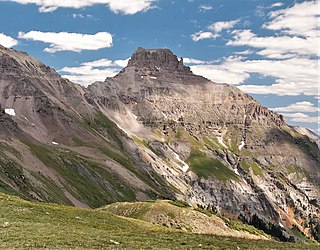
Teakettle Mountain, elevation 13,825 ft (4,214 m), is a summit in the Sneffels Range of southwest Colorado. The peak is west of Ouray in the Uncompahgre National Forest.

Gilpin Peak is a high mountain summit in the Sneffels Range of the Rocky Mountains of North America. The 13,700-foot (4,176 m) thirteener is located in the Mount Sneffels Wilderness of Uncompahgre National Forest, 3.5 miles (5.6 km) north-northeast of the Town of Telluride, Colorado, United States, on the drainage divide between Ouray County and San Miguel County. Gilpin Peak was named in honor of William Gilpin, the first Governor of the Territory of Colorado.

Mears Peak is a 13,496-foot-elevation mountain summit located on the common boundary of Ouray County with San Miguel County, in Colorado, United States. It is situated six miles northwest of the community of Telluride, in the Mount Sneffels Wilderness, on land managed by Uncompahgre National Forest. It is part of the Sneffels Range which is a subset of the San Juan Mountains, which in turn is part of the Rocky Mountains. Mears Peak is situated west of the Continental Divide, and 3.8 miles west of Mount Sneffels. Topographic relief is significant as the south aspect rises 4,900 feet (1,493 meters) above the San Miguel River in approximately 5.5 miles.
Potosi Peak is a 13,786-foot-elevation mountain summit located in Ouray County of Colorado, United States. It is situated five miles southwest of the community of Ouray, on land managed by Uncompahgre National Forest. It is part of the Sneffels Range which is a subset of the San Juan Mountains, which in turn is part of the Rocky Mountains. It is situated west of the Continental Divide, 2.2 miles south of Whitehouse Mountain, and 2.5 miles southeast of Mount Sneffels. Potosi ranks as the 113th-highest peak in Colorado, and the fourth-highest in the Sneffels Range. Recreation enthusiasts heading for Yankee Boy Basin traverse below the southern base of the mountain. Topographic relief is significant as the southeast aspect rises 4,000 feet (1,220 meters) above the Camp Bird Mine in approximately 1.5 mile. The mining activity in the immediate area produced significant amounts of gold and silver. "Potosi" in Quechuan language translates to "great wealth.". The mountain's name, which has been officially adopted by the United States Board on Geographic Names, was in use before 1899 when Henry Gannett published it in A Dictionary of Altitudes in the United States.

Mount Emma is a 13,581-foot-elevation mountain summit located in San Miguel County of Colorado, United States. It is situated three miles north of the community of Telluride, on the south side of Yankee Boy Basin, in the Uncompahgre National Forest. It is part of the Sneffels Range which is a subset of the San Juan Mountains, which in turn is part of the Rocky Mountains. Mount Emma is situated west of the Continental Divide, two miles south of Mount Sneffels, and 0.8 mile south of Gilpin Peak, the nearest higher neighbor. Emma ranks as the 197th-highest peak in Colorado, and the 10th-highest in the Sneffels Range. Topographic relief is significant as the south aspect rises 4,830 feet (1,472 meters) above Telluride in approximately three miles. An ascent of Mt. Emma is a difficult climb with 2,180 feet of elevation gain covering three miles from Yankee Boy Basin, or 4,836 feet of elevation gain from Telluride. This mountain's name was officially adopted by the U.S. Board on Geographic Names.

Cirque Mountain is a 13,686-foot-elevation (4,171 meter) mountain summit located in Ouray County of southwest Colorado, United States. It is situated six miles west of the community of Ouray, above the north side of Yankee Boy Basin, on land managed by Uncompahgre National Forest. It is part of the Sneffels Range which is a subset of the San Juan Mountains, which in turn is part of the Rocky Mountains. Cirque ranks as the 155th-highest peak in Colorado, and the ninth-highest in the Sneffels Range. It is west of the Continental Divide, 1.12 mile east of Mount Sneffels, and 0.59 mile west of Teakettle Mountain, which is the nearest higher neighbor. Topographic relief is significant as the north aspect rises 3,000 feet (914 meters) above Blaine Basin in one mile, and the south aspect rises over 2,000 feet above Yankee Boy Basin in less than one mile. These basins are cirques which were carved by ancient glaciers. The mountain's name has been officially adopted by the United States Board on Geographic Names.


