
The Dandenong Ranges are a set of low mountain ranges in Victoria, Australia, approximately 35 km (22 mi) east of the state capital Melbourne. A minor branch of the Great Dividing Range, the Dandenongs consist mostly of rolling hills, rising to 633 m (2,077 ft) at Mount Dandenong, as well as steeply weathered valleys and gullies covered in thick temperate rainforest, predominantly of tall mountain ash trees and dense ferny undergrowth. The namesaked Dandenong Creek and most of its left-bank tributaries originate from headwaters in these mountain ranges. Two of Melbourne's most important storage reservoirs, the Cardinia and Silvan Reservoir, are also located within the Dandenongs.

The Uinta Mountains are an east-west trending chain of mountains in northeastern Utah extending a short distance into northwest Colorado and slightly into southwestern Wyoming in the United States. As a subrange of the Rocky Mountains, they are unusual for being the highest range in the contiguous United States running east to west, and lie approximately 100 miles (160 km) east of Salt Lake City. The range has peaks ranging from 11,000 to 13,528 feet, with the highest point being Kings Peak, also the highest point in Utah. The Mirror Lake Highway crosses the western half of the Uintas on its way to Wyoming. Utah state highway 44 crosses the east end of the Uintas between Vernal UT and Manila UT.

Mount Timpanogos, often referred to as Timp, is the second-highest mountain in Utah's Wasatch Range. Timpanogos rises to an elevation of 11,752 ft (3,582 m) above sea level in the Uinta-Wasatch-Cache National Forest. With 5,270 ft (1,610 m) of topographic prominence, Timpanogos is the 47th-most prominent mountain in the contiguous United States.

The Idaho Panhandle National Forests are a jointly administered set of three national forests located mostly in the U.S. state of Idaho. In 1973, major portions of the Kaniksu, Coeur d'Alene, and St. Joe National Forests were combined to be administratively managed as the Idaho Panhandle National Forests (IPNF). The IPNF consists of more than 2.5 million acres (10,000 km2) of public lands in the panhandle of north Idaho, with small areas extending into eastern Washington (4.7%) and western Montana (1.2%). The northernmost portion of the IPNF share a boundary with Canada. The Forest Supervisor's office is located in Coeur d'Alene, Idaho with district office's in Bonners Ferry, Sandpoint, Priest River, Fernan and Smelterville, and St. Maries and Avery.
Emerald Lake may refer to:

Mount Timpanogos Wilderness is a 10,518-acre (42.56 km2) wilderness area protecting Mount Timpanogos and the surrounding area. It is located in the front range of the Wasatch Mountain Range, between American Fork Canyon on the north and Provo Canyon on the south, within the Uinta-Wasatch-Cache National Forest on the north eastern edge of Utah County, Utah, United States. The wilderness area receives fairly heavy use due to its proximity to the heavily populated cities of Provo and Salt Lake City. It is bordered on the north by the Lone Peak Wilderness.

Hallett Peak is a mountain summit in the northern Front Range of the Rocky Mountains of North America. The 12,720-foot (3,877 m) peak is located in the Rocky Mountain National Park Wilderness, 10.1 miles (16.2 km) southwest by west of the Town of Estes Park, Colorado, United States, on the Continental Divide between Grand and Larimer counties.

The Chelan Mountains, or Chelan Range is a mountain range in the U.S. state of Washington. Located west of the Columbia River, north of the Entiat River, and south of Lake Chelan, the range is part of the North Cascades section of the Cascade Range. The Chelan Range is about 40 mi (64 km) long northwest to southeast and about 8 mi (13 km) wide, southwest to northeast.
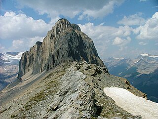
Wapta Mountain is a mountain located in the Canadian Rockies between Emerald Lake and Yoho Valley in Yoho National Park, British Columbia, Canada. It stands just north of the ridge containing the Burgess Shale fossil beds. Along with The Vice President and Mount Burgess, Wapta Mountain forms the backdrop to Emerald Lake, and marks the southern end of the President Range.

The Atascosa Mountains is a mountain range in western Santa Cruz County, Arizona, United States. It is sandwiched between the larger Tumacacori Mountains to the north, and a small east–west border range to the south, the Pajarito Mountains; the Pajaritos are on the U.S.–Mexico border and abut the Sierra La Esmeralda range in northern Sonora.
The San Luis Mountains are a small, lower elevation mountain range of central-southern Pima County Arizona adjacent to the U.S.-Mexico border, northeast of Sasabe, Arizona–Sasabe, Sonora.
The Pajarito Mountains is a small mountain range of western Santa Cruz County, Arizona, United States, that extend south into Sonora, Mexico. The range is adjacent the Atascosa Mountains at its north, with both ranges in the center of a north-south sequence of ranges called the Tumacacori Highlands. The Highlands have the Tumacacori Mountains at the north, and south of the U.S.-Mexico border, the Sierra La Esmeralda range. The Tumacacori Highlands are part of a regional conservancy study of "travel corridors" for cats, called Cuatro Gatos, Four Cats, for mountain lions, ocelot, bobcat, and jaguar.
Emerald Peak is a high mountain summit of the Collegiate Peaks in the Sawatch Range of the Rocky Mountains of North America. The 13,911-foot (4,240 m) thirteener is located in the Collegiate Peaks Wilderness of San Isabel National Forest, 14.7 miles (23.7 km) west-northwest of the Town of Buena Vista in Chaffee County, Colorado, United States.
Mount Dandenong is a mountain that is part of the Dandenong Ranges of the Great Dividing Range, located in the Central District of Victoria, Australia. The mountain has an elevation of 633 metres (2,077 ft) AHD and is located approximately 45 kilometres (28 mi) east of Melbourne.

Cheyenne Mountain is a triple-peaked mountain in El Paso County, Colorado, southwest of downtown Colorado Springs. The mountain serves as a host for military, communications, recreational, and residential functions. The underground operations center for the North American Aerospace Defense Command (NORAD) was built during the Cold War to monitor North American airspace for missile launches and Soviet military aircraft. Built deep within granite, it was designed to withstand the impact and fallout from a nuclear bomb. Its function broadened with the end of the Cold War, and then many of its functions were transferred to Peterson Air Force Base in 2006.

Emerald Peak is a 2,701-metre (8,862-foot) mountain summit located in Yoho National Park, in the Canadian Rockies of British Columbia, Canada. Its nearest higher peak is Mount Carnarvon, 1.7 km (1.1 mi) to the northwest. Both are part of the President Range which is a subset of the Waputik Mountains. Emerald Peak is visible from Emerald Lake, rising 1,256-metre (4,121-foot) above the northwest shore. The mountain's name was officially adopted in 1924 when approved by the Geographical Names Board of Canada, in association with Emerald Lake, which in turn was named in 1900 on account of its color.

The Tumacacori Mountains is a mountain range in Santa Cruz and Pima counties in southern Arizona, United States. The highest peak in the range is an unnamed summit with an elevation of 5,736 feet (1,748 m).

Emerald Peak is an 8,422 ft (2,570 m) mountain summit located in the Chelan Mountains, in Chelan County of Washington state. The mountain is situated in Glacier Peak Wilderness of the North Cascades, on land managed by Wenatchee National Forest. Its nearest higher peak is Cardinal Peak, 1.1 mi (1.8 km) to the southeast, and Saska Peak is positioned 0.66 mi (1.06 km) to the west-southwest. These three highest peaks of the Chelan Mountains enclose the head of North Fork Entiat River valley. Bearcat Ridge radiates from Emerald Peak one mile to the northeast. Precipitation runoff from the peak drains into the Chelan River and Entiat River drainage basins. The first ascent of this peak was made in 1937 by William A. Long. Emerald Peak ranks as the second-highest peak in the Chelan Mountains, and 70th-highest summit in Washington state.

Emerald Peak is a 12,546-foot-elevation (3,824-meter) mountain summit located west of the crest of the Sierra Nevada mountain range, in Fresno County of central California, United States. It is situated in northern Kings Canyon National Park, southwest of Evolution Valley, and 2.3 miles (3.7 km) northwest of Mount McGee, the nearest higher neighbor. Other nearby peaks include The Hermit, 2.5 miles (4.0 km) to the east, and Peter Peak, 1.6 miles (2.6 km) to the southeast. Topographic relief is significant as the west aspect rises over 3,500 feet above Goddard Canyon in 1.5 mile. The John Muir Trail passes to the northeast, providing an approach.