| United States Mountain | |
|---|---|
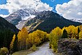
 Northeast aspect, from Camp Bird Road | |
| Highest point | |
| Elevation | 13,036 ft (3,973 m) [1] |
| Prominence | 156 ft (48 m) [1] |
| Parent peak | Chicago Peak (13,385 ft) [2] |
| Isolation | 0.95 mi (1.53 km) [2] |
| Coordinates | 37°57′24″N107°44′20″W / 37.9565533°N 107.7390025°W [3] |
| Geography | |
 United States Mountain Location in Colorado  United States Mountain United States Mountain (the United States) | |
| Location | Ouray County Colorado, US |
| Parent range | Rocky Mountains San Juan Mountains Sneffels Range [1] |
| Topo map | USGS Ironton |
United States Mountain is a 13,036-foot-elevation (3,973-meter) mountain summit located in Ouray County of southwest Colorado, United States. [3] It is situated six miles southwest of the community of Ouray, on land managed by Uncompahgre National Forest. It is part of the Sneffels Range which is a subset of the San Juan Mountains, which in turn is part of the Rocky Mountains. It is set west of the Continental Divide, 2.3 miles south of Potosi Peak, and 2.5 miles southeast of Stony Mountain. Recreation enthusiasts heading for Yankee Boy Basin traverse below the northern base of the mountain. Topographic relief is significant as the north aspect rises 3,300 feet (1,000 meters) above the Camp Bird Mine in approximately one mile. Mining activity in the immediate area produced significant amounts of gold and silver. [4] The Hidden Treasure Mine is a gold mine located on the south slope at 11,759-feet elevation. [5]